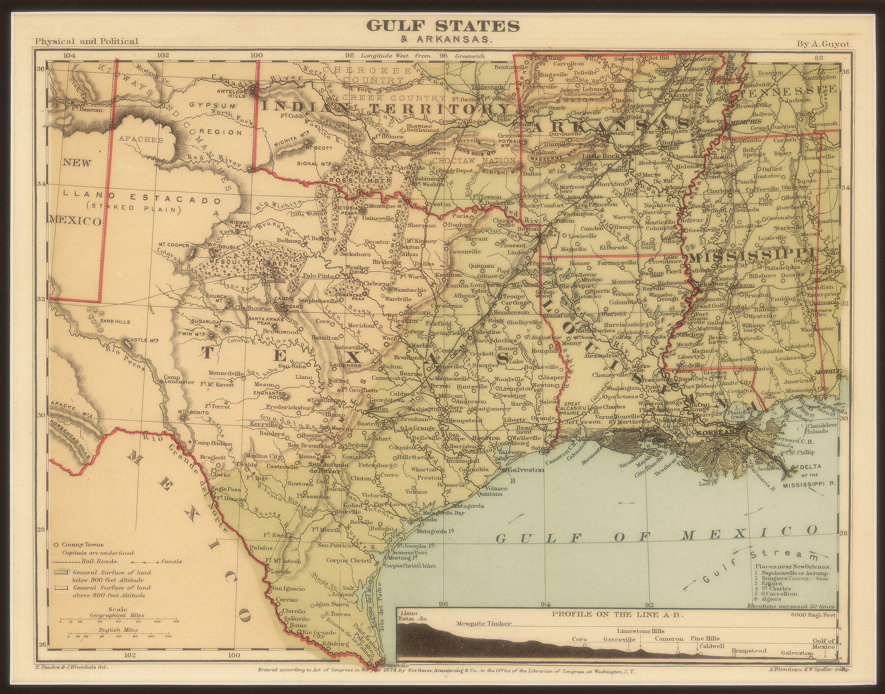
Gulf States and Arkansas
-
Map/Doc
95285
-
Collection
Non-GLO Digital Images
-
Object Dates
1874 (Creation Date)
-
People and Organizations
Scribner Armstrong and Co. (Publisher)
A. Blondeau & W. Speller (Printer)
A. Blondeau (Engraver)
W. Speller (Engraver)
A. Guyot (Author)
-
Subjects
Old Southwest State of Texas
-
Height x Width
9.4 x 12.0 inches
23.9 x 30.5 cm
-
Medium
digital image
-
Comments
Digital image courtesy of an anonymous supporter of the Texas General Land Office in 2018.
Part of: Non-GLO Digital Images
Map of New York and Adjacent Cities

Print $20.00
- Digital $50.00
Map of New York and Adjacent Cities
1860
Size 17.8 x 28.7 inches
Map/Doc 94439


Waco, Tex., County Seat of McLennan Co.

Print $20.00
Waco, Tex., County Seat of McLennan Co.
1886
Size 23.1 x 32.7 inches
Map/Doc 89212
Descripción y Mapa de la Nueva Provincia, poblada de Bárbaros, situada en la Costa del Seno Mexicano, desde el puerto de Tampico hasta la Provincia de Texas

Descripción y Mapa de la Nueva Provincia, poblada de Bárbaros, situada en la Costa del Seno Mexicano, desde el puerto de Tampico hasta la Provincia de Texas
1744
Size 32.0 x 29.1 inches
Map/Doc 94558
El Nuevo México y Tierras Adyacentes Levantado para la Demarcación de los Límites de los Dominios Españoles y de los Estados Unidos

El Nuevo México y Tierras Adyacentes Levantado para la Demarcación de los Límites de los Dominios Españoles y de los Estados Unidos
1811
Size 9.4 x 12.6 inches
Map/Doc 94445
The Official Map of the City of El Paso, State of Texas

Print $40.00
The Official Map of the City of El Paso, State of Texas
1889
Size 83.6 x 97.2 inches
Map/Doc 89619
Ladonia, Fannin County, Texas

Print $20.00
Ladonia, Fannin County, Texas
1891
Size 12.0 x 22.1 inches
Map/Doc 89097
The Rand-McNally New Commercial Atlas Map of Texas

Print $20.00
The Rand-McNally New Commercial Atlas Map of Texas
1914
Size 28.6 x 42.4 inches
Map/Doc 78225
County Map of Texas, and Indian Territory

Print $20.00
County Map of Texas, and Indian Territory
1872
Size 18.9 x 16.1 inches
Map/Doc 88820
A New Map of ye North Parts of America according to the division thereof by the Articles of Peace in 1763

Print $20.00
A New Map of ye North Parts of America according to the division thereof by the Articles of Peace in 1763
1763
Size 8.5 x 11.3 inches
Map/Doc 95280
You may also like
City of Littlefield Lamb County Texas Located on Texas State Capitol League 664

Print $20.00
- Digital $50.00
City of Littlefield Lamb County Texas Located on Texas State Capitol League 664
Size 41.0 x 37.1 inches
Map/Doc 89911
Map of Texas containing the latest Grants and Discoveries

Print $20.00
- Digital $50.00
Map of Texas containing the latest Grants and Discoveries
1836
Size 12.7 x 9.1 inches
Map/Doc 93855
Dimmit County Sketch File 33

Print $4.00
- Digital $50.00
Dimmit County Sketch File 33
1884
Size 8.2 x 8.4 inches
Map/Doc 21151
Wonderland, Randolph Place, and Deer Wood

Print $20.00
- Digital $50.00
Wonderland, Randolph Place, and Deer Wood
Size 18.9 x 24.8 inches
Map/Doc 92742
Mills County Boundary File 6

Print $2.00
- Digital $50.00
Mills County Boundary File 6
Size 11.0 x 8.6 inches
Map/Doc 57311
Upper Galveston Bay, Houston Ship Channel, Dollar Pt. to Atkinson I.

Print $40.00
- Digital $50.00
Upper Galveston Bay, Houston Ship Channel, Dollar Pt. to Atkinson I.
1978
Size 49.3 x 36.8 inches
Map/Doc 69898
Nolan County Rolled Sketch 2A

Print $20.00
- Digital $50.00
Nolan County Rolled Sketch 2A
Size 26.9 x 34.8 inches
Map/Doc 6861
Gregg County Working Sketch 11b

Print $20.00
- Digital $50.00
Gregg County Working Sketch 11b
1940
Size 11.9 x 15.3 inches
Map/Doc 63278
Map of Garza County, Texas

Print $20.00
- Digital $50.00
Map of Garza County, Texas
1936
Size 28.7 x 36.3 inches
Map/Doc 92648
University of Texas System University Lands

Print $20.00
- Digital $50.00
University of Texas System University Lands
1929
Size 23.2 x 17.7 inches
Map/Doc 93246
Andrews County Working Sketch 32

Print $20.00
- Digital $50.00
Andrews County Working Sketch 32
1990
Size 29.6 x 31.5 inches
Map/Doc 67078
[Blocks DT, P, CK, C2, and D7]
![91307, [Blocks DT, P, CK, C2, and D7], Twichell Survey Records](https://historictexasmaps.com/wmedia_w700/maps/91307-1.tif.jpg)
Print $20.00
- Digital $50.00
[Blocks DT, P, CK, C2, and D7]
Size 23.6 x 9.6 inches
Map/Doc 91307