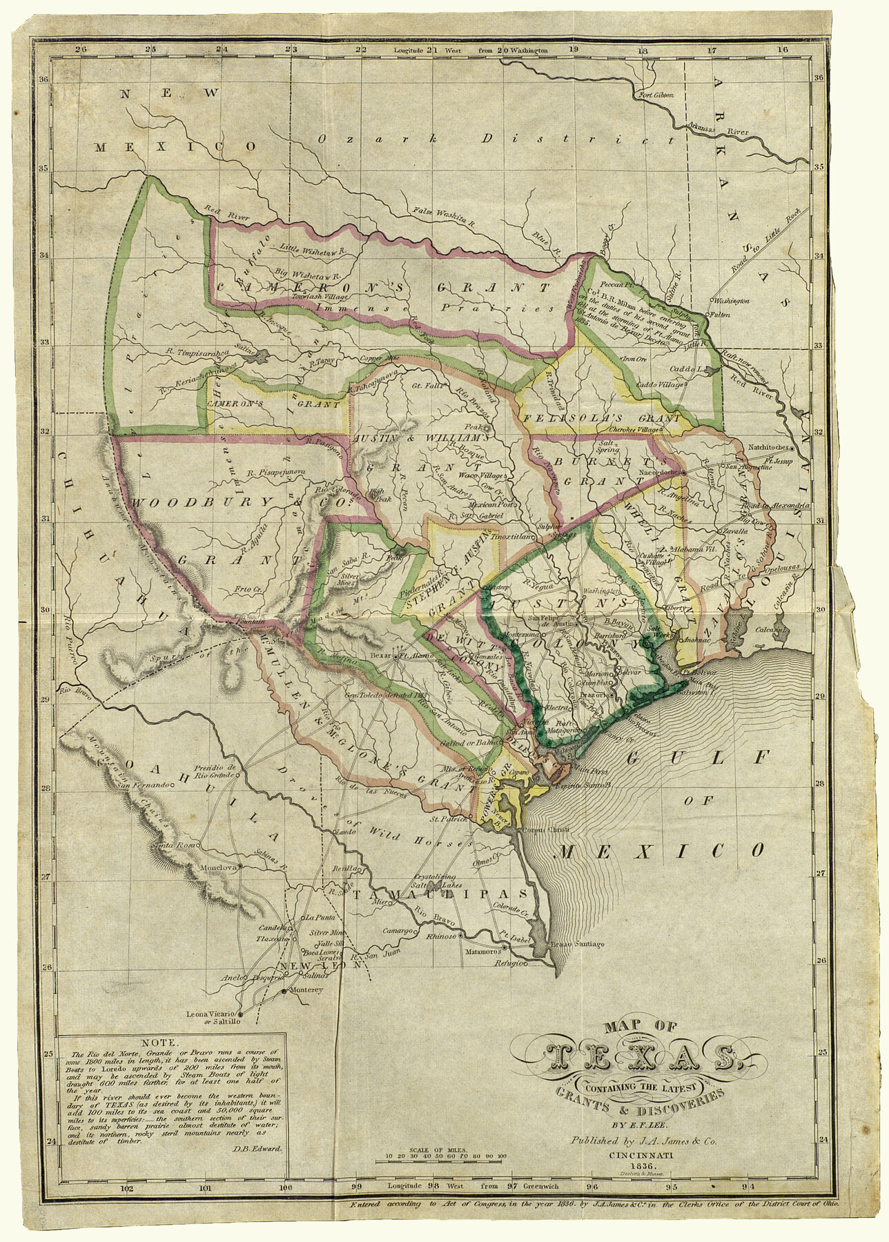
Map of Texas containing the latest Grants and Discoveries
-
Map/Doc
93855
-
Collection
Holcomb Map Collection
-
Object Dates
1836 (Creation Date)
-
People and Organizations
J. A. James & Co. (Publisher)
E.F. Lee (Author)
-
Subjects
Republic of Texas
-
Height x Width
12.7 x 9.1 inches
32.3 x 23.1 cm
-
Comments
From the book: "The History of Texas; or, the Emigrants, Farmer's, and Politician's Guide to the Character, Climate, Soil and Productions of that Country; geographically arranged from personal observation and experience." by David B. Edward. Courtesy of
-
URLs
https://medium.com/save-texas-history/mapping-texas-from-frontier-to-the-lone-star-state-coahuila-y-texas-8716db26290a#.gz4l4s41h
Part of: Holcomb Map Collection
General Topographical Map. Sheet XXII

Print $20.00
- Digital $50.00
General Topographical Map. Sheet XXII
1891
Size 18.4 x 29.4 inches
Map/Doc 97526
Amèrica noviter delineata

Print $20.00
- Digital $50.00
Amèrica noviter delineata
1630
Size 21.5 x 24.7 inches
Map/Doc 93814
Map and Description of Texas, containing sketches of its history, geology, geography and statistics: with concise statements, relative to the soil, climate, productions, facilities of transportation, population of the country;

Print $324.00
- Digital $50.00
Map and Description of Texas, containing sketches of its history, geology, geography and statistics: with concise statements, relative to the soil, climate, productions, facilities of transportation, population of the country;
1840
Size 6.1 x 4.1 inches
Map/Doc 93861
Map of Texas and the Countries Adjacent compiled in the Bureau of the Corps of Topographical Engineers from the Best Authorities

Print $2.00
- Digital $50.00
Map of Texas and the Countries Adjacent compiled in the Bureau of the Corps of Topographical Engineers from the Best Authorities
1844
Size 8.1 x 5.0 inches
Map/Doc 93868
Americae nova Tabula

Print $20.00
- Digital $50.00
Americae nova Tabula
1635
Size 18.4 x 24.3 inches
Map/Doc 93812
Americae Sive Novi Orbis Nova Descriptio

Print $20.00
- Digital $50.00
Americae Sive Novi Orbis Nova Descriptio
1606
Size 16.4 x 22.3 inches
Map/Doc 93829
Map of Asia designed to accompany Smith's Geography for Schools

Print $20.00
- Digital $50.00
Map of Asia designed to accompany Smith's Geography for Schools
1850
Size 9.6 x 12.0 inches
Map/Doc 93896
Il Disegno del discoperto della nova Franza, il quale se havuto ultimamente dalla novissima navigatione dè Francesi in quel luogo

Print $20.00
- Digital $50.00
Il Disegno del discoperto della nova Franza, il quale se havuto ultimamente dalla novissima navigatione dè Francesi in quel luogo
1566
Size 12.6 x 18.6 inches
Map/Doc 93804
Americae nova Tabula

Print $20.00
- Digital $50.00
Americae nova Tabula
1617
Size 16.0 x 21.5 inches
Map/Doc 93813
A New Map of Texas with the Contiguous American & Mexican States

Print $20.00
- Digital $50.00
A New Map of Texas with the Contiguous American & Mexican States
1835
Size 12.9 x 15.8 inches
Map/Doc 93853
Map of the British Isles designed to accompany Smith's Geography for Schools

Print $20.00
- Digital $50.00
Map of the British Isles designed to accompany Smith's Geography for Schools
1850
Size 12.1 x 9.8 inches
Map/Doc 93894
Americae Sive Novi Orbis Nova Descriptio

Print $20.00
- Digital $50.00
Americae Sive Novi Orbis Nova Descriptio
1579
Size 18.0 x 22.9 inches
Map/Doc 93805
You may also like
Map of Rains County

Print $20.00
- Digital $50.00
Map of Rains County
1873
Size 12.0 x 12.4 inches
Map/Doc 4619
Flight Mission No. BRE-2P, Frame 22, Nueces County

Print $20.00
- Digital $50.00
Flight Mission No. BRE-2P, Frame 22, Nueces County
1956
Size 18.7 x 22.6 inches
Map/Doc 86731
Map of Nacogdoches County

Print $40.00
- Digital $50.00
Map of Nacogdoches County
1839
Size 83.6 x 43.2 inches
Map/Doc 93370
Gray County Sketch File 8

Print $20.00
- Digital $50.00
Gray County Sketch File 8
1888
Size 17.7 x 20.7 inches
Map/Doc 11577
Sutton County Rolled Sketch 68

Print $20.00
- Digital $50.00
Sutton County Rolled Sketch 68
Size 31.0 x 37.4 inches
Map/Doc 9980
Taylor County Rolled Sketch 25

Print $20.00
- Digital $50.00
Taylor County Rolled Sketch 25
1962
Size 27.1 x 46.0 inches
Map/Doc 7917
Taylor County Rolled Sketch 21

Print $20.00
- Digital $50.00
Taylor County Rolled Sketch 21
Size 31.5 x 40.5 inches
Map/Doc 9985
El Paso County Sketch File 26

Print $20.00
- Digital $50.00
El Paso County Sketch File 26
Size 24.8 x 21.9 inches
Map/Doc 11457
Calhoun County Working Sketch 6

Print $20.00
- Digital $50.00
Calhoun County Working Sketch 6
1943
Size 20.8 x 24.1 inches
Map/Doc 67822
Ellwood Farms Subdivision Number 2 of the Spade Ranch Lamb and Hale Counties, Texas

Print $20.00
- Digital $50.00
Ellwood Farms Subdivision Number 2 of the Spade Ranch Lamb and Hale Counties, Texas
Size 22.2 x 31.4 inches
Map/Doc 92258
Flight Mission No. DIX-10P, Frame 72, Aransas County

Print $20.00
- Digital $50.00
Flight Mission No. DIX-10P, Frame 72, Aransas County
1956
Size 18.8 x 22.4 inches
Map/Doc 83933
San Patricio County Sketch File 33

Print $20.00
- Digital $50.00
San Patricio County Sketch File 33
1946
Size 15.5 x 31.0 inches
Map/Doc 12288