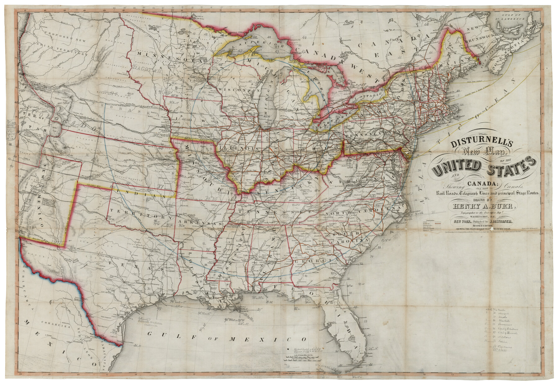
Disturnell's New Map of the United States and Canada; showing all the canals, railroads, telegraph lines and principal stage routes
-
Map/Doc
93900
-
Collection
Holcomb Map Collection
-
Object Dates
1853 (Creation Date)
-
People and Organizations
J. Disturnell (Publisher)
J. M. Atwood (Printer)
Henry A. Burr (Draftsman)
-
Subjects
United States
-
Height x Width
28.1 x 40.9 inches
71.4 x 103.9 cm
-
Comments
See 93919 for original cover for this map. Courtesy of Frank and Carol Holcomb.
Part of: Holcomb Map Collection
Map of the Western States designed to accompany Smith's Geography for Schools

Print $20.00
- Digital $50.00
Map of the Western States designed to accompany Smith's Geography for Schools
1850
Size 12.2 x 19.1 inches
Map/Doc 93889
Richardson's New Map of the State of Texas Including Part of Mexico Compiled From Government Surveys and Other Authentic Documents

Print $20.00
- Digital $50.00
Richardson's New Map of the State of Texas Including Part of Mexico Compiled From Government Surveys and Other Authentic Documents
1860
Size 28.5 x 36.3 inches
Map/Doc 96788
Americae nova Tabula

Print $20.00
- Digital $50.00
Americae nova Tabula
1635
Size 18.4 x 24.3 inches
Map/Doc 93812
A New & Correct Map of the Trading Part of the West Indies, including the Seat of War between Gr. Britain and France Likewise the British Empire in America, with the French and Spanish Settlements adjacent thereto

Print $20.00
- Digital $50.00
A New & Correct Map of the Trading Part of the West Indies, including the Seat of War between Gr. Britain and France Likewise the British Empire in America, with the French and Spanish Settlements adjacent thereto
1759
Size 27.4 x 41.4 inches
Map/Doc 93826
Map of Texas compiled from surveys recorded in the Land Office of Texas, and other official surveys

Print $20.00
- Digital $50.00
Map of Texas compiled from surveys recorded in the Land Office of Texas, and other official surveys
1843
Size 27.1 x 22.5 inches
Map/Doc 93863
Map of Texas compiled from surveys at the Land Office of Texas

Print $20.00
- Digital $50.00
Map of Texas compiled from surveys at the Land Office of Texas
1851
Size 26.7 x 19.1 inches
Map/Doc 96431
La Riviere de Missisipi, et ses environs, dans l'Amerique Septentrionale

Print $20.00
- Digital $50.00
La Riviere de Missisipi, et ses environs, dans l'Amerique Septentrionale
1715
Size 22.0 x 27.8 inches
Map/Doc 96518
A Geographically Correct Map of the State of Texas

Print $20.00
- Digital $50.00
A Geographically Correct Map of the State of Texas
1876
Size 19.6 x 21.4 inches
Map/Doc 96508
America siue India Nova ad magnae Gerardi Mercatoris aui Vniversalis imitationem in compendium redacta

Print $20.00
- Digital $50.00
America siue India Nova ad magnae Gerardi Mercatoris aui Vniversalis imitationem in compendium redacta
1585
Size 16.9 x 20.2 inches
Map/Doc 93808


Perry and Spaulding's American Republic and Railroad Map of the United States and of the Dominion of Canada

Print $40.00
- Digital $50.00
Perry and Spaulding's American Republic and Railroad Map of the United States and of the Dominion of Canada
1874
Size 40.5 x 55.7 inches
Map/Doc 93913
You may also like
Grayson County Working Sketch 18

Print $20.00
- Digital $50.00
Grayson County Working Sketch 18
1955
Size 22.8 x 21.1 inches
Map/Doc 63257
Hansford County Boundary File 3

Print $10.00
- Digital $50.00
Hansford County Boundary File 3
Size 13.6 x 8.7 inches
Map/Doc 54270
Flight Mission No. CRC-3R, Frame 202, Chambers County

Print $20.00
- Digital $50.00
Flight Mission No. CRC-3R, Frame 202, Chambers County
1956
Size 18.7 x 22.4 inches
Map/Doc 84857
Fractional Township No. 7 South Range No. 19 East of the Indian Meridian, Indian Territory

Print $20.00
- Digital $50.00
Fractional Township No. 7 South Range No. 19 East of the Indian Meridian, Indian Territory
1897
Size 19.2 x 24.3 inches
Map/Doc 75235
[San Antonio & Aransas Pass]
![64210, [San Antonio & Aransas Pass], General Map Collection](https://historictexasmaps.com/wmedia_w700/maps/64210.tif.jpg)
Print $20.00
- Digital $50.00
[San Antonio & Aransas Pass]
Size 35.4 x 14.8 inches
Map/Doc 64210
Flight Mission No. CRC-4R, Frame 108, Chambers County

Print $20.00
- Digital $50.00
Flight Mission No. CRC-4R, Frame 108, Chambers County
1956
Size 18.7 x 22.4 inches
Map/Doc 84905
La Salle County Sketch File 39

Print $6.00
- Digital $50.00
La Salle County Sketch File 39
1912
Size 16.4 x 11.4 inches
Map/Doc 29592
Jeff Davis County Sketch File 48

Print $3.00
- Digital $50.00
Jeff Davis County Sketch File 48
2002
Size 14.0 x 8.5 inches
Map/Doc 82923
Baffin and Alazan Bays, Cayo Infiernillo in Kenedy and Kleberg Counties, showing Subdivision for Mineral Development

Print $40.00
- Digital $50.00
Baffin and Alazan Bays, Cayo Infiernillo in Kenedy and Kleberg Counties, showing Subdivision for Mineral Development
1949
Size 33.0 x 52.4 inches
Map/Doc 1923
Winkler County Sketch File 18

Print $8.00
- Digital $50.00
Winkler County Sketch File 18
1999
Size 11.2 x 8.7 inches
Map/Doc 40517
Nueces River, Corpus Christi Sheet No. 3

Print $6.00
- Digital $50.00
Nueces River, Corpus Christi Sheet No. 3
1938
Size 31.7 x 25.9 inches
Map/Doc 65091
Fort Bend County State Real Property Sketch 15

Print $20.00
- Digital $50.00
Fort Bend County State Real Property Sketch 15
1985
Size 34.9 x 43.5 inches
Map/Doc 61689