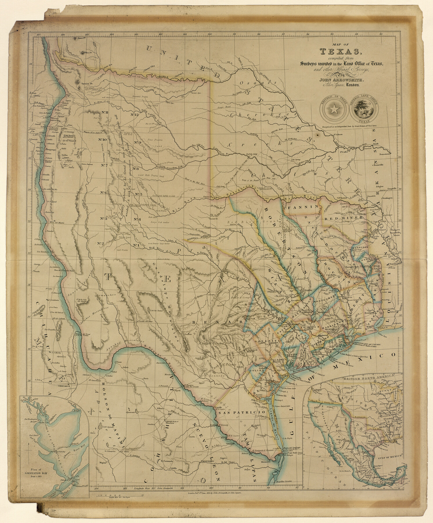
Map of Texas compiled from surveys recorded in the Land Office of Texas, and other official surveys
[Inset:] Plan of Galveston Bay
-
Map/Doc
93863
-
Collection
Holcomb Map Collection
-
Object Dates
1843 (Creation Date)
-
People and Organizations
John Arrowsmith (Author)
-
Subjects
Republic of Texas
-
Height x Width
27.1 x 22.5 inches
68.8 x 57.2 cm
-
Comments
Courtesy of Frank and Carol Holcomb.
Part of: Holcomb Map Collection
Map of the World on Mercator's Projection, flags of all nations and cities of the United States

Print $40.00
- Digital $50.00
Map of the World on Mercator's Projection, flags of all nations and cities of the United States
1874
Size 40.4 x 55.6 inches
Map/Doc 93914
La Riviere de Missisipi, et ses environs, dans l'Amerique Septentrionale

Print $20.00
- Digital $50.00
La Riviere de Missisipi, et ses environs, dans l'Amerique Septentrionale
1715
Size 22.0 x 27.8 inches
Map/Doc 96518
Carte de la Louisiane et du Cours du Mississipi

Print $20.00
- Digital $50.00
Carte de la Louisiane et du Cours du Mississipi
1718
Size 20.6 x 27.3 inches
Map/Doc 93821
Map of the United States and Canada

Print $2.00
- Digital $50.00
Map of the United States and Canada
1853
Size 6.2 x 4.2 inches
Map/Doc 93919
Map of the United States of America, the British Provinces, Mexico, the West Indies and Central America with part of New Granada and Venezuela

Print $20.00
- Digital $50.00
Map of the United States of America, the British Provinces, Mexico, the West Indies and Central America with part of New Granada and Venezuela
1855
Size 34.7 x 44.0 inches
Map/Doc 93904
Il Disegno del discoperto della nova Franza, il quale se havuto ultimamente dalla novissima navigatione dè Francesi in quel luogo

Print $20.00
- Digital $50.00
Il Disegno del discoperto della nova Franza, il quale se havuto ultimamente dalla novissima navigatione dè Francesi in quel luogo
1566
Size 12.6 x 18.6 inches
Map/Doc 93804
Traveller's Map of the State of Texas

Print $20.00
- Digital $50.00
Traveller's Map of the State of Texas
1867
Size 43.4 x 41.6 inches
Map/Doc 93906
[Map of the Texas & Pacific Railway and connections]
![95414, [Map of the Texas & Pacific Railway and connections], Holcomb Digital Map Collection](https://historictexasmaps.com/wmedia_w700/maps/95414.tif.jpg)
Print $20.00
- Digital $50.00
[Map of the Texas & Pacific Railway and connections]
1902
Size 18.0 x 37.0 inches
Map/Doc 95414
Map No. 2. Eastern States designed to accompany Smith's Geography for School

Print $20.00
- Digital $50.00
Map No. 2. Eastern States designed to accompany Smith's Geography for School
1850
Size 9.6 x 12.1 inches
Map/Doc 93886
Americae Sive Novi Orbis Nova Descriptio

Print $20.00
- Digital $50.00
Americae Sive Novi Orbis Nova Descriptio
1606
Size 16.5 x 22.4 inches
Map/Doc 93810
Map of the Middle States designed to accompany Smith's Geography for Schools

Print $20.00
- Digital $50.00
Map of the Middle States designed to accompany Smith's Geography for Schools
1850
Size 19.4 x 12.2 inches
Map/Doc 93887
Map of the West Indies designed to accompany Smith's Geography for Schools

Print $20.00
- Digital $50.00
Map of the West Indies designed to accompany Smith's Geography for Schools
1850
Size 9.6 x 12.0 inches
Map/Doc 93893
You may also like
Orange County Working Sketch 12

Print $20.00
- Digital $50.00
Orange County Working Sketch 12
1922
Size 17.2 x 12.7 inches
Map/Doc 71344
Abstract of Land Titles in the Spanish Department of the General Land Office of the State of Texas - 1824-36

Abstract of Land Titles in the Spanish Department of the General Land Office of the State of Texas - 1824-36
1857
Size 17.6 x 11.9 inches
Map/Doc 94535
[Texas and Pacific Railway Company, Block 44, Township One South]
![89845, [Texas and Pacific Railway Company, Block 44, Township One South], Twichell Survey Records](https://historictexasmaps.com/wmedia_w700/maps/89845-1.tif.jpg)
Print $40.00
- Digital $50.00
[Texas and Pacific Railway Company, Block 44, Township One South]
Size 42.0 x 59.2 inches
Map/Doc 89845
Brooks County

Print $20.00
- Digital $50.00
Brooks County
1955
Size 40.3 x 32.2 inches
Map/Doc 77223
Map of T. C. Ivey's Ranch Block D - John H. Gibson

Print $20.00
- Digital $50.00
Map of T. C. Ivey's Ranch Block D - John H. Gibson
Size 13.9 x 14.0 inches
Map/Doc 92853
Sketch in Martin County Showing Survey 13, Block X

Print $2.00
- Digital $50.00
Sketch in Martin County Showing Survey 13, Block X
1908
Size 12.6 x 8.4 inches
Map/Doc 91286
Houston County Rolled Sketch 6

Print $40.00
- Digital $50.00
Houston County Rolled Sketch 6
1963
Size 48.0 x 34.3 inches
Map/Doc 9182
Kleberg County Aerial Photograph Index Sheet 4

Print $20.00
- Digital $50.00
Kleberg County Aerial Photograph Index Sheet 4
1956
Size 19.3 x 23.3 inches
Map/Doc 83721
Floyd County Working Sketch 5

Print $20.00
- Digital $50.00
Floyd County Working Sketch 5
1955
Size 33.3 x 23.6 inches
Map/Doc 69184
Morris County Rolled Sketch 2A

Print $20.00
- Digital $50.00
Morris County Rolled Sketch 2A
Size 35.2 x 27.7 inches
Map/Doc 10270
Upton County Sketch File 31

Print $20.00
- Digital $50.00
Upton County Sketch File 31
Size 5.8 x 20.7 inches
Map/Doc 38883
Kent County Working Sketch 14

Print $20.00
- Digital $50.00
Kent County Working Sketch 14
1965
Size 28.2 x 35.4 inches
Map/Doc 70021