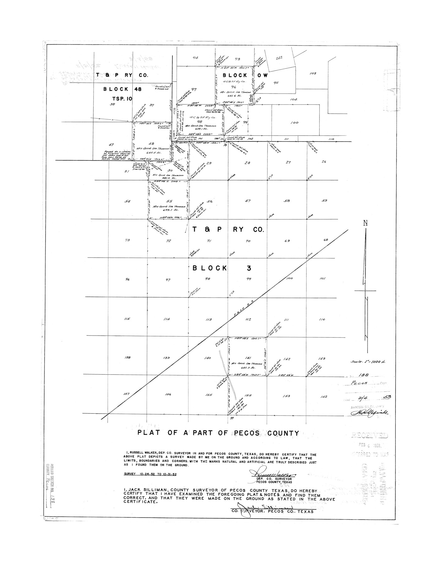
Pecos County Rolled Sketch 138
Plat of a part of Pecos County [showing northern part of Block 3, T. & P. Ry. Co. and surrounding areas]
-
Map/Doc
7274
-
Collection
General Map Collection
-
Object Dates
1952/10/31 (Survey Date)
1953/2/4 (File Date)
-
People and Organizations
Russell Walker (Surveyor/Engineer)
-
Counties
Pecos
-
Subjects
Surveying Rolled Sketch
-
Height x Width
27.9 x 21.7 inches
70.9 x 55.1 cm
-
Scale
1" = 1000 varas
Part of: General Map Collection

Harrison County Rolled Sketch 8

Print $33.00
- Digital $50.00
Harrison County Rolled Sketch 8
Size 10.1 x 15.2 inches
Map/Doc 45825
Orange County Sketch File 9b

Print $22.00
- Digital $50.00
Orange County Sketch File 9b
1873
Size 14.6 x 12.6 inches
Map/Doc 33315
La Salle County Working Sketch 24

Print $20.00
- Digital $50.00
La Salle County Working Sketch 24
1947
Size 20.9 x 31.2 inches
Map/Doc 70325
Cameron County Aerial Photograph Index Sheet 8

Print $20.00
- Digital $50.00
Cameron County Aerial Photograph Index Sheet 8
1955
Size 20.4 x 16.1 inches
Map/Doc 83680
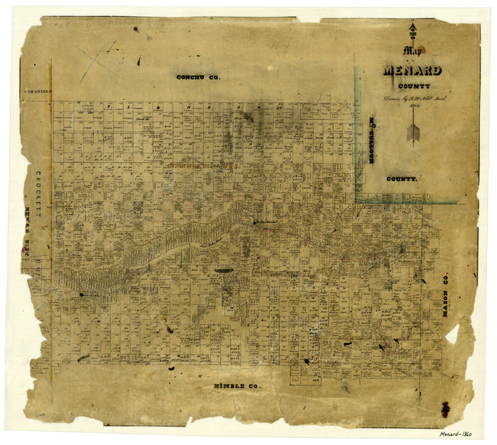
Map of Menard County
Print $20.00
- Digital $50.00
Map of Menard County
1860
Size 20.9 x 23.3 inches
Map/Doc 3874
A Geographically Correct Map of the State of Texas

Print $20.00
- Digital $50.00
A Geographically Correct Map of the State of Texas
1876
Size 20.4 x 21.7 inches
Map/Doc 95361
Map of McClennan County

Print $20.00
- Digital $50.00
Map of McClennan County
1868
Size 22.8 x 25.4 inches
Map/Doc 3861
Karnes County Working Sketch 15

Print $20.00
- Digital $50.00
Karnes County Working Sketch 15
1987
Size 36.0 x 41.1 inches
Map/Doc 66663
Dickens County Sketch File 2a

Print $4.00
- Digital $50.00
Dickens County Sketch File 2a
1884
Size 14.2 x 8.9 inches
Map/Doc 20950
Val Verde County Sketch File 19a

Print $42.00
- Digital $50.00
Val Verde County Sketch File 19a
Size 29.4 x 15.1 inches
Map/Doc 12568
Lavaca County Working Sketch 9

Print $20.00
- Digital $50.00
Lavaca County Working Sketch 9
1949
Size 24.7 x 33.9 inches
Map/Doc 70362
You may also like
General Highway Map, Upshur County, Gregg County, Texas

Print $20.00
General Highway Map, Upshur County, Gregg County, Texas
1939
Size 24.9 x 18.6 inches
Map/Doc 79105
[Coordinates for Block H, Sections 1 and 2 and Block C41, Section 4]
![92566, [Coordinates for Block H, Sections 1 and 2 and Block C41, Section 4], Twichell Survey Records](https://historictexasmaps.com/wmedia_w700/maps/92566-1.tif.jpg)
Print $3.00
- Digital $50.00
[Coordinates for Block H, Sections 1 and 2 and Block C41, Section 4]
1940
Size 11.4 x 17.4 inches
Map/Doc 92566
Newton County Rolled Sketch 14

Print $40.00
- Digital $50.00
Newton County Rolled Sketch 14
1953
Size 33.4 x 56.0 inches
Map/Doc 9579
Ward County Rolled Sketch 26

Print $28.00
- Digital $50.00
Ward County Rolled Sketch 26
Size 9.9 x 15.0 inches
Map/Doc 49468
McLennan County Boundary File 7

Print $8.00
- Digital $50.00
McLennan County Boundary File 7
Size 14.1 x 8.6 inches
Map/Doc 57005
Hays County Sketch File 18

Print $4.00
- Digital $50.00
Hays County Sketch File 18
1878
Size 13.0 x 8.1 inches
Map/Doc 26235

Flight Mission No. DIX-10P, Frame 181, Aransas County

Print $20.00
- Digital $50.00
Flight Mission No. DIX-10P, Frame 181, Aransas County
1956
Size 18.5 x 22.2 inches
Map/Doc 83971
Location of the Southern Kansas Railway of Texas, Carson County, Texas

Print $40.00
- Digital $50.00
Location of the Southern Kansas Railway of Texas, Carson County, Texas
1887
Size 20.5 x 84.3 inches
Map/Doc 64035
Cooke County Working Sketch 32

Print $20.00
- Digital $50.00
Cooke County Working Sketch 32
1982
Size 19.0 x 14.8 inches
Map/Doc 68269
Shelby County

Print $20.00
- Digital $50.00
Shelby County
1945
Size 41.6 x 45.9 inches
Map/Doc 73288
Nueces County Rolled Sketch 4

Print $20.00
- Digital $50.00
Nueces County Rolled Sketch 4
1910
Size 39.8 x 38.5 inches
Map/Doc 9583