Jackson County Sketch File 28
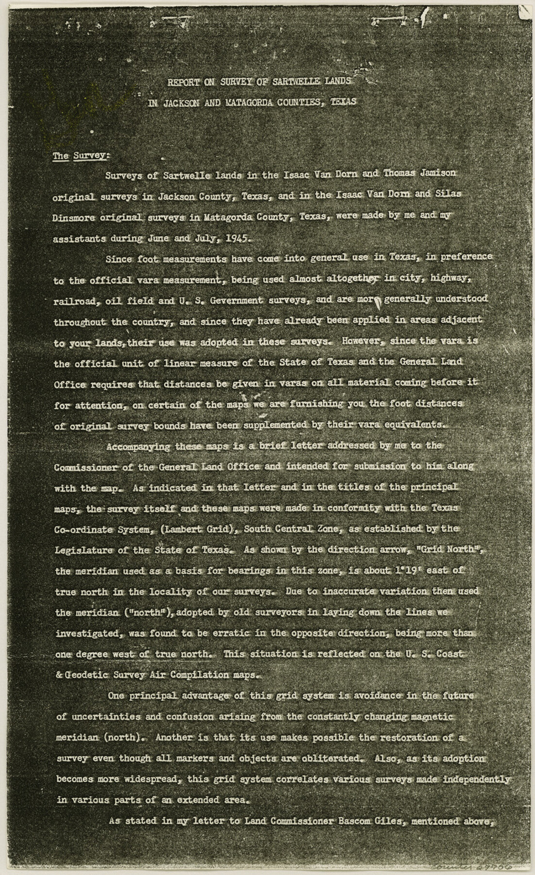
[Report on survey of Sartwelle Lands in Jackson and Matagorda Counties]
- 
                          Map/Doc27706
- 
                            CollectionGeneral Map Collection
- 
                            Object Dates1945 (Creation Date)1978/11/22 (File Date)1945 (Survey Date)1945 (Survey Date)1937/10/29 (Survey Date)1830 (Survey Date)1907 (Survey Date)1937/10/16 (File Date)
- 
                            People and OrganizationsConrad M. Blucher (Surveyor/Engineer)H.A. Pierce (Surveyor/Engineer)F.G. Hoffman (Surveyor/Engineer)A.C. Russell-Lindsay (Surveyor/Engineer)H.M Henderson (Surveyor/Engineer)J.C. Carrington (Surveyor/Engineer)Seth Ingram (Surveyor/Engineer)J.O. Barrow (Surveyor/Engineer)
- 
                            CountiesJackson Matagorda Calhoun
- 
                            SubjectsSurveying Sketch File
- 
                            Height x Width14.2 x 8.7 inches36.1 x 22.1 cm
- 
                            Mediumpaper, photocopy
- 
                            CommentsSee Jackson County Rolled Sketch 15 (9261) for sketch.
- 
                            FeaturesKoch SubdivisionCarancahua BayTres Palacios BayTurtle BayMatagorda BayCamp Hulen
Related maps
            Jackson County Rolled Sketch 15


                                            Print $40.00                    
                                             -                         Digital $50.00                                    
                Jackson County Rolled Sketch 15
1945
Size 53.7 x 30.3 inches
                                Map/Doc 9261
            Part of: General Map Collection
            Haskell County Sketch File 15


                                            Print $24.00                    
                                             -                         Digital $50.00                                    
                Haskell County Sketch File 15
1893
Size 13.5 x 16.5 inches
                                Map/Doc 26158
            
            Terry County Working Sketch 4


                                            Print $20.00                    
                                             -                         Digital $50.00                                    
                Terry County Working Sketch 4
Size 24.9 x 29.6 inches
                                Map/Doc 62109
            
            Galveston County NRC Article 33.136 Sketch 91


                                            Print $68.00                    
                                    
                Galveston County NRC Article 33.136 Sketch 91
2021
Map/Doc 97022
            
            Pecos County Working Sketch 142


                                            Print $40.00                    
                                             -                         Digital $50.00                                    
                Pecos County Working Sketch 142
2007
Size 38.0 x 63.4 inches
                                Map/Doc 88610
            
            Official Map of the State of Texas to accompany the Statistical and Descriptive Work, "Resources, Soil and Climate of Texas"


                                            Print $20.00                    
                                             -                         Digital $50.00                                    
                Official Map of the State of Texas to accompany the Statistical and Descriptive Work, "Resources, Soil and Climate of Texas"
1882
Size 31.1 x 33.1 inches
                                Map/Doc 2134
            
            McMullen County Working Sketch 1


                                            Print $20.00                    
                                             -                         Digital $50.00                                    
                McMullen County Working Sketch 1
1911
Size 20.9 x 13.1 inches
                                Map/Doc 70702
            
            Dimmit County Sketch File 9a


                                            Print $4.00                    
                                             -                         Digital $50.00                                    
                Dimmit County Sketch File 9a
Size 12.7 x 8.2 inches
                                Map/Doc 21073
            
            Kaufman County Sketch File 8


                                            Print $4.00                    
                                             -                         Digital $50.00                                    
                Kaufman County Sketch File 8
1851
Size 13.3 x 9.2 inches
                                Map/Doc 28638
            
            Map showing lands acquired for reservoir purposes in connection with Lake Worth and the boundary of territory annexed to the City of Fort Worth, Texas


                                            Print $40.00                    
                                             -                         Digital $50.00                                    
                Map showing lands acquired for reservoir purposes in connection with Lake Worth and the boundary of territory annexed to the City of Fort Worth, Texas
Size 46.4 x 58.9 inches
                                Map/Doc 62209
            
            Trinity County Working Sketch 11


                                            Print $20.00                    
                                             -                         Digital $50.00                                    
                Trinity County Working Sketch 11
1949
Size 47.0 x 42.6 inches
                                Map/Doc 69460
            You may also like
            Colorado County Working Sketch 32


                                            Print $20.00                    
                                             -                         Digital $50.00                                    
                Colorado County Working Sketch 32
1985
Size 42.7 x 36.8 inches
                                Map/Doc 68132
            
            Correct Map of the Railway and Steamship Lines operated by the Southern Pacific Company


                                            Print $20.00                    
                                    
                Correct Map of the Railway and Steamship Lines operated by the Southern Pacific Company
1894
Size 17.1 x 40.1 inches
                                Map/Doc 79322
            
            Kendall County Sketch File 26


                                            Print $12.00                    
                                             -                         Digital $50.00                                    
                Kendall County Sketch File 26
1950
Size 11.2 x 8.8 inches
                                Map/Doc 28725
            
            Midland County Boundary File 1a


                                            Print $4.00                    
                                             -                         Digital $50.00                                    
                Midland County Boundary File 1a
Size 9.5 x 6.0 inches
                                Map/Doc 57160
            
            Intracoastal Waterway in Texas - Corpus Christi to Point Isabel including Arroyo Colorado to Mo. Pac. R.R. Bridge Near Harlingen


                                            Print $20.00                    
                                             -                         Digital $50.00                                    
                Intracoastal Waterway in Texas - Corpus Christi to Point Isabel including Arroyo Colorado to Mo. Pac. R.R. Bridge Near Harlingen
1933
Size 28.2 x 41.0 inches
                                Map/Doc 61853
            
            Presidio County Rolled Sketch 124


                                            Print $20.00                    
                                             -                         Digital $50.00                                    
                Presidio County Rolled Sketch 124
1984
Size 27.9 x 39.8 inches
                                Map/Doc 7396
            
            Atascosa County Rolled Sketch 12


                                            Print $40.00                    
                                             -                         Digital $50.00                                    
                Atascosa County Rolled Sketch 12
1944
Size 33.3 x 68.8 inches
                                Map/Doc 8429
            
            [Texas & Pacific Railway through Callahan County]
            
                                    ![64239, [Texas & Pacific Railway through Callahan County], General Map Collection](https://historictexasmaps.com/wmedia_w700/maps/64239.tif.jpg) 


    ![64239, [Texas & Pacific Railway through Callahan County], General Map Collection](https://historictexasmaps.com/wmedia_w700/maps/64239.tif.jpg) 
                                
            
                                            Print $20.00                    
                                             -                         Digital $50.00                                    
                [Texas & Pacific Railway through Callahan County]
1918
Size 21.1 x 9.3 inches
                                Map/Doc 64239
            
            Travis County Working Sketch 18


                                            Print $20.00                    
                                             -                         Digital $50.00                                    
                Travis County Working Sketch 18
1945
Size 30.4 x 42.9 inches
                                Map/Doc 69402
            
            Newton County


                                            Print $40.00                    
                                             -                         Digital $50.00                                    
                Newton County
1946
Size 49.7 x 43.6 inches
                                Map/Doc 95600
            
            Flight Mission No. BRA-3M, Frame 194, Jefferson County


                                            Print $20.00                    
                                             -                         Digital $50.00                                    
                Flight Mission No. BRA-3M, Frame 194, Jefferson County
1953
Size 18.8 x 22.4 inches
                                Map/Doc 85409
            
            Oldham County Boundary File 1


                                            Print $6.00                    
                                             -                         Digital $50.00                                    
                Oldham County Boundary File 1
Size 8.8 x 7.2 inches
                                Map/Doc 57731
             
                             
                                