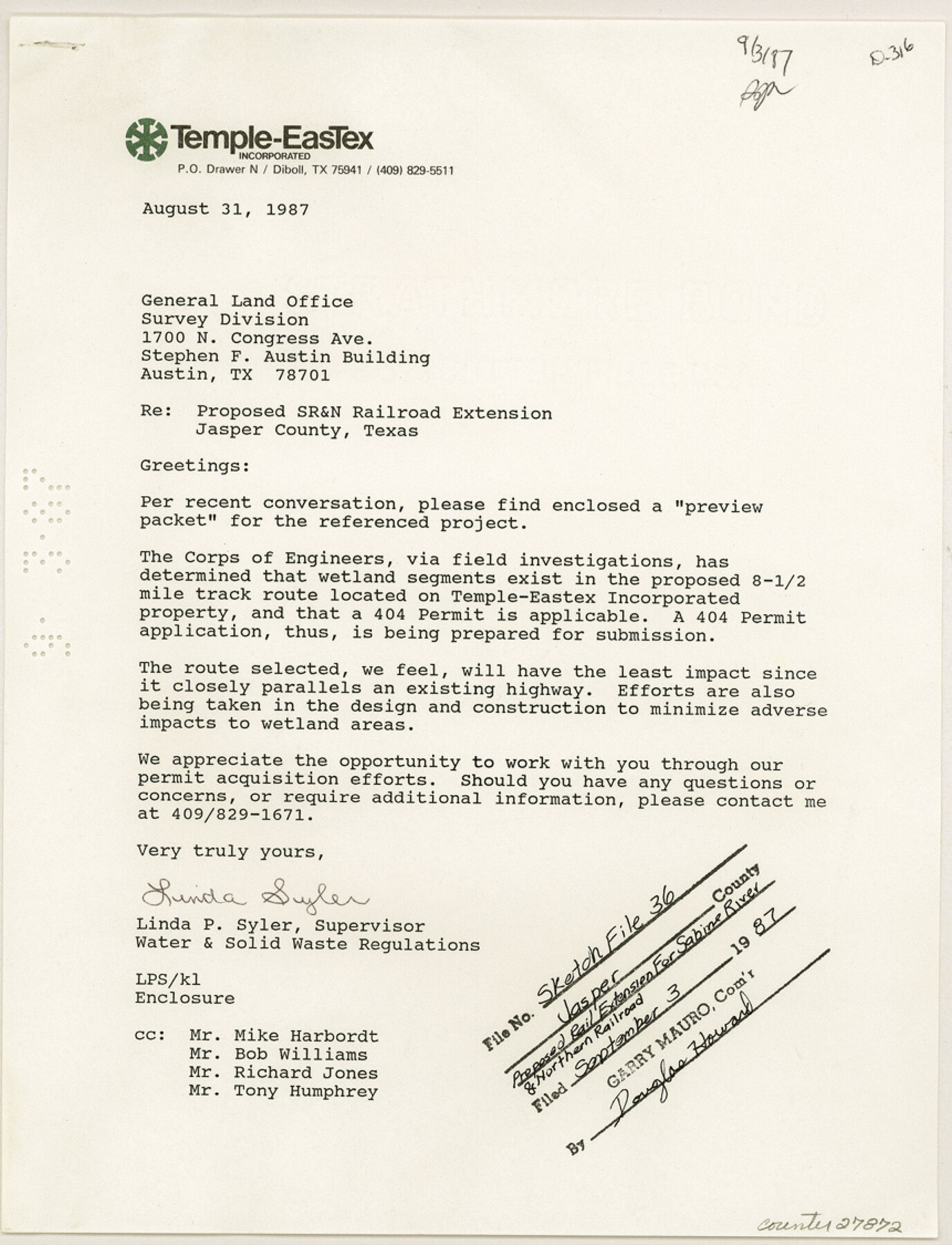
Jasper County Sketch File 36
[Proposed rail extension for Sabine River and Northern Railroad]
-
Map/Doc
27872
-
Collection
General Map Collection
-
Object Dates
8/31/1987 (Creation Date)
9/3/1987 (File Date)
8/31/1987 (Correspondence Date)
8/1987 (Survey Date)
-
People and Organizations
Jones and Neuse Inc. (Surveyor/Engineer)
-
Counties
Jasper Tyler Newton
-
Subjects
Surveying Sketch File
-
Height x Width
11.2 x 8.6 inches
28.5 x 21.8 cm
-
Medium
paper, print
-
Scale
1:800
-
Features
Beaumont
Raywood
Daisetta
Grayburg
Meeker
Devil Oaks
Orange
Clark
Batson
Devers
Orangefield
Pine Forest
Hartburg
Silsbee
Moss Hill
Votaw
Saratoga
Honey Island
Sour Lake
Highway 96
FM 1130
Lemonville
Sabine River
Mauriceville
Highway 12
FM 105
FM 1132
FM 1078
IH 10
Dognash Gully
Gum Slough
East Tenmile Creek
West Tenmile Creek
Doucette
Magnolia Springs
Spunger
Chester
Colmesneil
Warren
Woodville
Hillister
Town Bluff
Mount Union
Buna
Orange
SH 87
FM 2246
Gum Slough Road
FM 1131
SH 62
Sabine & Northern Railroad
Jasper
Holly Springs
Newton
Bleakwood
Belgrade
Liberty
Farrsville
Jamestown
Burkeville
Buckhorn
Salem
Dessmay
Deweyville
Evadale
Reeves
Part of: General Map Collection
Zapata County

Print $40.00
- Digital $50.00
Zapata County
1935
Size 56.7 x 43.2 inches
Map/Doc 63145
Preliminary Chart of Entrance to Brazos River, Texas

Print $20.00
- Digital $50.00
Preliminary Chart of Entrance to Brazos River, Texas
1858
Size 18.4 x 19.5 inches
Map/Doc 69973
Wood County Working Sketch 23

Print $40.00
- Digital $50.00
Wood County Working Sketch 23
1962
Size 54.9 x 43.5 inches
Map/Doc 78230

Sterling County Working Sketch 12

Print $20.00
- Digital $50.00
Sterling County Working Sketch 12
1989
Size 26.0 x 36.5 inches
Map/Doc 63994
Wharton County Sketch File 11

Print $4.00
- Digital $50.00
Wharton County Sketch File 11
1891
Size 9.1 x 12.3 inches
Map/Doc 39933
Reeves County Working Sketch 10

Print $20.00
- Digital $50.00
Reeves County Working Sketch 10
1956
Size 26.0 x 37.2 inches
Map/Doc 63453
Mitchell County Sketch File 11

Print $6.00
- Digital $50.00
Mitchell County Sketch File 11
1910
Size 11.2 x 8.8 inches
Map/Doc 31700
Edwards County

Print $20.00
- Digital $50.00
Edwards County
1893
Size 25.8 x 29.4 inches
Map/Doc 3506
Orange County Working Sketch 5

Print $20.00
- Digital $50.00
Orange County Working Sketch 5
1917
Size 12.6 x 20.6 inches
Map/Doc 71337
Hemphill County Working Sketch 21

Print $40.00
- Digital $50.00
Hemphill County Working Sketch 21
1973
Size 79.0 x 32.6 inches
Map/Doc 66116
Flight Mission No. DAG-21K, Frame 131, Matagorda County

Print $20.00
- Digital $50.00
Flight Mission No. DAG-21K, Frame 131, Matagorda County
1952
Size 18.6 x 22.4 inches
Map/Doc 86457
You may also like
Pecos County Working Sketch 43

Print $40.00
- Digital $50.00
Pecos County Working Sketch 43
1943
Size 19.5 x 50.7 inches
Map/Doc 71515
Duval County Working Sketch 22

Print $20.00
- Digital $50.00
Duval County Working Sketch 22
1942
Size 21.9 x 26.0 inches
Map/Doc 68746
Jasper County Working Sketch 16

Print $20.00
- Digital $50.00
Jasper County Working Sketch 16
1928
Size 13.7 x 14.3 inches
Map/Doc 66478
Index to Burnet's, [Vehlein's] & Zavala's Colonies
![94553, Index to Burnet's, [Vehlein's] & Zavala's Colonies, Historical Volumes](https://historictexasmaps.com/wmedia_w700/pdf_converted_jpg/qi_pdf_thumbnail_39142.jpg)
Index to Burnet's, [Vehlein's] & Zavala's Colonies
Map/Doc 94553
Presidio County Sketch File 115

Print $14.00
- Digital $50.00
Presidio County Sketch File 115
1993
Size 11.3 x 8.9 inches
Map/Doc 34835
[Stone, Kyle and Kyle Block M6]
![90395, [Stone, Kyle and Kyle Block M6], Twichell Survey Records](https://historictexasmaps.com/wmedia_w700/maps/90395-1.tif.jpg)
Print $20.00
- Digital $50.00
[Stone, Kyle and Kyle Block M6]
Size 26.8 x 21.6 inches
Map/Doc 90395
Cameron County Rolled Sketch 15

Print $40.00
- Digital $50.00
Cameron County Rolled Sketch 15
1958
Size 53.0 x 32.0 inches
Map/Doc 8568
Hood County Working Sketch 31

Print $20.00
- Digital $50.00
Hood County Working Sketch 31
1998
Size 33.6 x 35.8 inches
Map/Doc 66225
Garza County Sketch File 25

Print $4.00
- Digital $50.00
Garza County Sketch File 25
1907
Size 7.6 x 7.9 inches
Map/Doc 24086
Harris County Sketch File 32a

Print $4.00
- Digital $50.00
Harris County Sketch File 32a
1895
Size 14.1 x 9.0 inches
Map/Doc 25436
A Compleat Map of the West Indies, containing the Coasts of Florida, Louisiana, New Spain, and Terra Firma: with all the Islands

Print $20.00
- Digital $50.00
A Compleat Map of the West Indies, containing the Coasts of Florida, Louisiana, New Spain, and Terra Firma: with all the Islands
1774
Size 13.9 x 19.0 inches
Map/Doc 97400
Sutton County Rolled Sketch 67

Print $20.00
- Digital $50.00
Sutton County Rolled Sketch 67
Size 25.4 x 37.3 inches
Map/Doc 7902