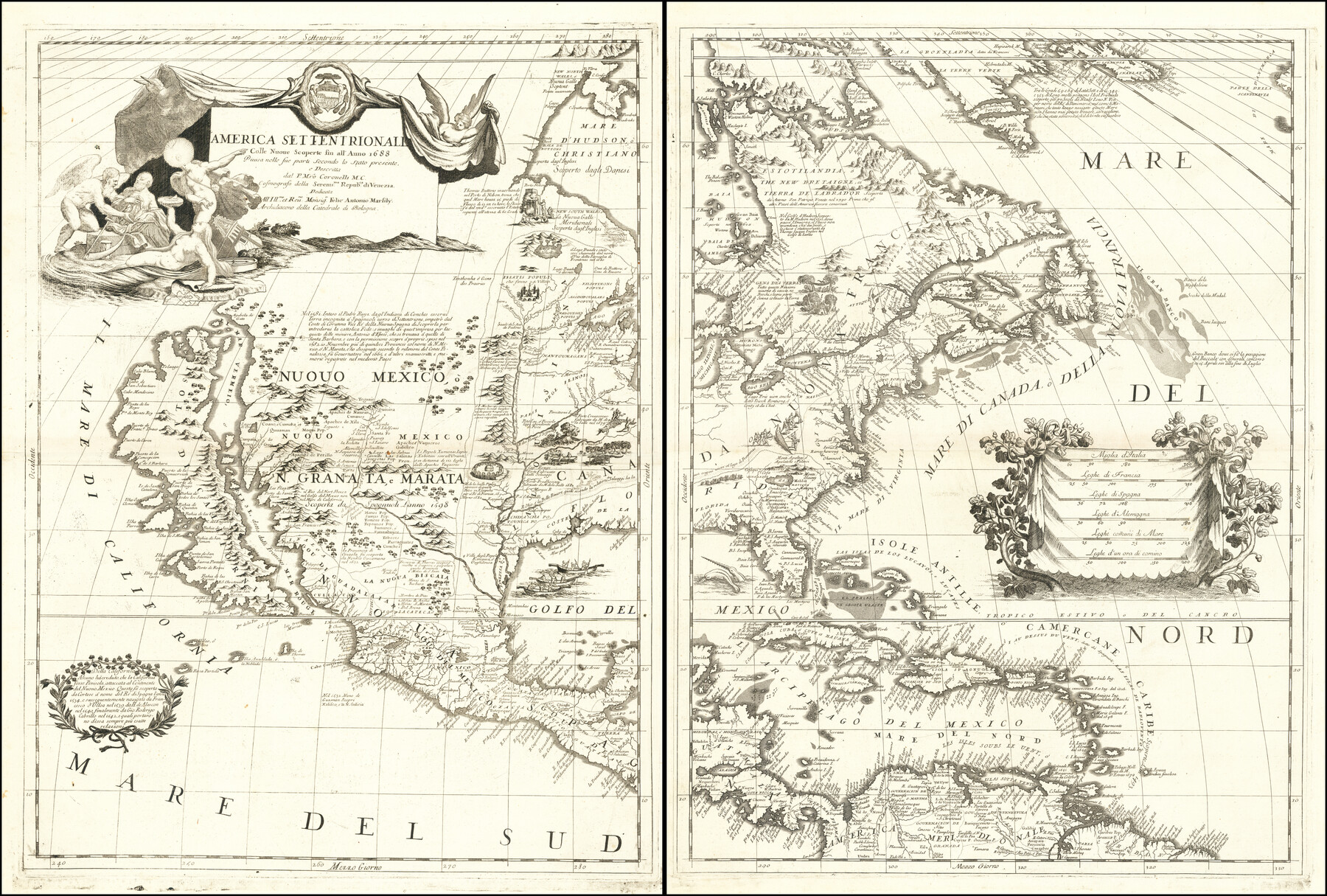
America Settentrionale Colle Nuoue Scoperte fin all' Anno 1688
-
Map/Doc
96506
-
Collection
Holcomb Digital Map Collection
-
Object Dates
1688 (Creation Date)
-
People and Organizations
[Vincenzo Maria] Coronelli (Author)
-
Subjects
North America
-
Height x Width
25.4 x 37.6 inches
64.5 x 95.5 cm
-
Medium
digital image
-
Comments
Courtesy of Frank and Carol Holcomb.
Part of: Holcomb Digital Map Collection
Map of Texas compiled from surveys included in the General Land Office

Print $20.00
- Digital $50.00
Map of Texas compiled from surveys included in the General Land Office
1851
Size 31.4 x 25.3 inches
Map/Doc 94417
The State of Texas

Print $20.00
- Digital $50.00
The State of Texas
1845
Size 18.9 x 23.2 inches
Map/Doc 93870
Carte de la Louisiane et du Cours du Mississipi

Print $20.00
- Digital $50.00
Carte de la Louisiane et du Cours du Mississipi
1718
Size 20.6 x 27.3 inches
Map/Doc 93821
Amèrica noviter delineata

Print $20.00
- Digital $50.00
Amèrica noviter delineata
1630
Size 21.5 x 24.7 inches
Map/Doc 93814
Map of Asia designed to accompany Smith's Geography for Schools

Print $20.00
- Digital $50.00
Map of Asia designed to accompany Smith's Geography for Schools
1850
Size 9.6 x 12.0 inches
Map/Doc 93896
Map of Texas compiled from surveys recorded in the Land Office of Texas, and other official surveys

Print $20.00
- Digital $50.00
Map of Texas compiled from surveys recorded in the Land Office of Texas, and other official surveys
1843
Size 27.1 x 22.5 inches
Map/Doc 93863
North America and the West Indies

Print $20.00
- Digital $50.00
North America and the West Indies
1763
Size 41.6 x 46.9 inches
Map/Doc 93834
L'Amerique Meridionale et Septentrionale

Print $20.00
- Digital $50.00
L'Amerique Meridionale et Septentrionale
1731
Size 20.0 x 28.3 inches
Map/Doc 93825
The History of Texas; or, the Emigrants, Farmer's, and Politician's Guide to the Character, Climate, Soil and Productions of that Country; geographically arranged from personal observation and experience.

Print $692.00
- Digital $50.00
The History of Texas; or, the Emigrants, Farmer's, and Politician's Guide to the Character, Climate, Soil and Productions of that Country; geographically arranged from personal observation and experience.
1836
Size 8.1 x 5.3 inches
Map/Doc 93856
Map No. 1. Eastern States designed to accompany Smith's Geography for School

Print $20.00
- Digital $50.00
Map No. 1. Eastern States designed to accompany Smith's Geography for School
1850
Size 9.8 x 12.1 inches
Map/Doc 93885
Map of Texas containing the latest Grants and Discoveries

Print $20.00
- Digital $50.00
Map of Texas containing the latest Grants and Discoveries
1836
Size 12.7 x 9.1 inches
Map/Doc 93855
Carta Geografica General de la Republica Mexicana

Print $40.00
- Digital $50.00
Carta Geografica General de la Republica Mexicana
1845
Size 38.1 x 52.9 inches
Map/Doc 96438
You may also like
McMullen County Working Sketch 47

Print $40.00
- Digital $50.00
McMullen County Working Sketch 47
1983
Size 55.8 x 43.3 inches
Map/Doc 70748
Archer County Working Sketch 24

Print $20.00
- Digital $50.00
Archer County Working Sketch 24
Size 21.0 x 35.8 inches
Map/Doc 67165
Kendall County Rolled Sketch 5

Print $20.00
- Digital $50.00
Kendall County Rolled Sketch 5
Size 23.4 x 19.3 inches
Map/Doc 6458
Maps of Gulf Intracoastal Waterway, Texas - Sabine River to the Rio Grande and connecting waterways including ship channels

Print $20.00
- Digital $50.00
Maps of Gulf Intracoastal Waterway, Texas - Sabine River to the Rio Grande and connecting waterways including ship channels
1966
Size 14.5 x 22.2 inches
Map/Doc 61969
Flight Mission No. CGI-1N, Frame 175, Cameron County

Print $20.00
- Digital $50.00
Flight Mission No. CGI-1N, Frame 175, Cameron County
1955
Size 18.7 x 22.2 inches
Map/Doc 84510
King County Survey

Print $20.00
- Digital $50.00
King County Survey
1916
Size 25.6 x 30.5 inches
Map/Doc 91021
Jeff Davis County Rolled Sketch 19

Print $40.00
- Digital $50.00
Jeff Davis County Rolled Sketch 19
1885
Size 37.1 x 57.9 inches
Map/Doc 9265
Map of Red River Division of International & Great Northern Railroad

Print $40.00
- Digital $50.00
Map of Red River Division of International & Great Northern Railroad
Size 23.5 x 103.4 inches
Map/Doc 64475
Blanco County Sketch File 52

Print $4.00
- Digital $50.00
Blanco County Sketch File 52
Size 11.3 x 8.9 inches
Map/Doc 76332
Dawson County Rolled Sketch 10

Print $20.00
- Digital $50.00
Dawson County Rolled Sketch 10
1954
Size 44.5 x 37.9 inches
Map/Doc 8774
Flight Mission No. CGN-1G, Frame 26, San Patricio County

Print $20.00
- Digital $50.00
Flight Mission No. CGN-1G, Frame 26, San Patricio County
1950
Size 9.4 x 9.4 inches
Map/Doc 87113
Duval County Sketch File 26

Print $4.00
- Digital $50.00
Duval County Sketch File 26
1882
Size 13.0 x 9.0 inches
Map/Doc 21332