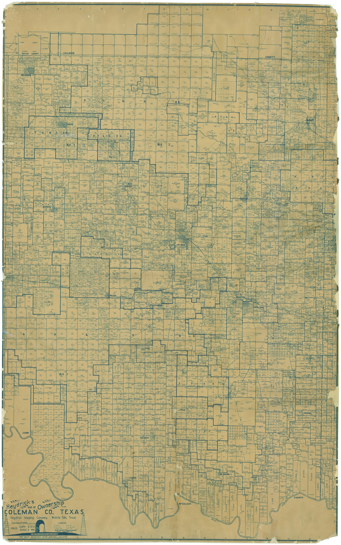
Coleman County
-
Map/Doc
81518
-
Collection
Non-GLO Digital Images
-
Object Dates
1949 (Creation Date)
-
People and Organizations
Heydrick Mapping Company (Publisher)
Lawrence C. Heydrick (Compiler)
-
Counties
Coleman
-
Subjects
County
-
Height x Width
68.6 x 43.1 inches
174.2 x 109.5 cm
-
Comments
Part of a collection of the Miller Day Ranch in Coleman County, Texas. Original map donated to the University of Texas by James Miller. Legend defines symbols for wells.
-
Features
Dressy
Urania
Davies Creek
Whon
Rockwood
Camp Creek
Hardin
Colorado River
Santa Anna Mountain
Buffalo Creek
Buck Creek
Leaday
Little Pecan Creek
Clear Creek
Goldsboro
Jim Ned Creek
Pecan Bayou
Burkett
Rough Creek
Santa Fe Railroad
Novice
Santa Anna
Echo
Lake Scarbrough
Glencove
Hord's Creek
Camp Colorado
Lake Coleman
Coleman
Talpa
Cunningham Creek
Valera
Silver Valley
State Highway No. 7
Home Creek
Fisk
Voss
Mukewater Creek
Shield
Trickham
Goldbusk
Elm Creek
Part of: Non-GLO Digital Images
[Movements & Objectives of the 143rd & 144th Infantry on October 13, 1918, Appendix L]
![94124, [Movements & Objectives of the 143rd & 144th Infantry on October 13, 1918, Appendix L], Non-GLO Digital Images](https://historictexasmaps.com/wmedia_w700/maps/94124-1.tif.jpg)
Print $20.00
[Movements & Objectives of the 143rd & 144th Infantry on October 13, 1918, Appendix L]
1918
Size 16.1 x 16.8 inches
Map/Doc 94124
A Geological Map of the United States and Canada

Print $20.00
A Geological Map of the United States and Canada
1853
Size 17.4 x 25.0 inches
Map/Doc 95189
Railroad Commissioner's Map of Texas

Print $20.00
Railroad Commissioner's Map of Texas
1897
Size 27.0 x 23.0 inches
Map/Doc 90070
A Map of the United States of Mexico as organized and defined by the several Acts of the Congress of that Republic

Print $20.00
A Map of the United States of Mexico as organized and defined by the several Acts of the Congress of that Republic
1826
Size 23.2 x 28.9 inches
Map/Doc 93635
The Rand-McNally New Commercial Atlas Map of Texas

Print $20.00
The Rand-McNally New Commercial Atlas Map of Texas
1914
Size 42.7 x 28.6 inches
Map/Doc 78226
El Nuevo México y Tierras Adyacentes Levantado para la Demarcación de los Límites de los Dominios Españoles y de los Estados Unidos

El Nuevo México y Tierras Adyacentes Levantado para la Demarcación de los Límites de los Dominios Españoles y de los Estados Unidos
1811
Size 9.4 x 12.6 inches
Map/Doc 94445
The Official Map of the City of El Paso, State of Texas

Print $40.00
The Official Map of the City of El Paso, State of Texas
1889
Size 83.6 x 97.2 inches
Map/Doc 89619
Austin, State Capital of Texas

Print $20.00
Austin, State Capital of Texas
1887
Size 27.5 x 40.0 inches
Map/Doc 89218
Karte von Afrika

Print $20.00
- Digital $50.00
Karte von Afrika
1888
Size 28.9 x 35.5 inches
Map/Doc 97503

City Map of Weatherford, Texas

Print $20.00
City Map of Weatherford, Texas
Size 46.0 x 46.8 inches
Map/Doc 93697
Bird's Eye View of La Grange, Fayette County, Texas

Print $20.00
Bird's Eye View of La Grange, Fayette County, Texas
1880
Size 24.1 x 31.2 inches
Map/Doc 89096
You may also like
Brewster County Sketch File NS-14

Print $160.00
- Digital $50.00
Brewster County Sketch File NS-14
1970
Size 8.2 x 6.5 inches
Map/Doc 16224
Garza County Sketch File 2

Print $20.00
- Digital $50.00
Garza County Sketch File 2
Size 33.1 x 30.3 inches
Map/Doc 10462
Medina County Sketch File 3

Print $4.00
- Digital $50.00
Medina County Sketch File 3
Size 8.1 x 7.3 inches
Map/Doc 31445
Ward County Rolled Sketch 25

Print $20.00
- Digital $50.00
Ward County Rolled Sketch 25
1970
Size 38.7 x 19.9 inches
Map/Doc 8165
Jasper County Working Sketch 3

Print $20.00
- Digital $50.00
Jasper County Working Sketch 3
Size 17.8 x 14.1 inches
Map/Doc 66465
Presidio County Sketch File 6

Print $20.00
- Digital $50.00
Presidio County Sketch File 6
Size 21.3 x 17.8 inches
Map/Doc 11705
Bowie County Sketch File 2

Print $40.00
- Digital $50.00
Bowie County Sketch File 2
Size 19.6 x 15.1 inches
Map/Doc 10940
Flight Mission No. DQN-5K, Frame 31, Calhoun County

Print $20.00
- Digital $50.00
Flight Mission No. DQN-5K, Frame 31, Calhoun County
1953
Size 18.5 x 22.1 inches
Map/Doc 84382
Medina County Sketch File 16

Print $8.00
- Digital $50.00
Medina County Sketch File 16
1948
Size 11.4 x 8.8 inches
Map/Doc 31476
[Map of Surveys in Dallam, Texas]
![1768, [Map of Surveys in Dallam, Texas], General Map Collection](https://historictexasmaps.com/wmedia_w700/maps/1768.tif.jpg)
Print $20.00
- Digital $50.00
[Map of Surveys in Dallam, Texas]
1910
Size 19.5 x 27.8 inches
Map/Doc 1768
Live Oak County Working Sketch 3

Print $20.00
- Digital $50.00
Live Oak County Working Sketch 3
1910
Size 21.5 x 19.0 inches
Map/Doc 70588
Falls County Sketch File 18a

Print $8.00
- Digital $50.00
Falls County Sketch File 18a
Size 13.3 x 9.0 inches
Map/Doc 22382