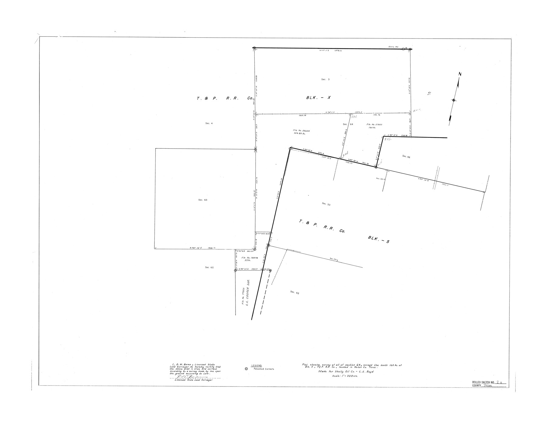
Nolan County Rolled Sketch 2A
Plat showing survey of all of section 64, except the south 160 ac. of Blk. X, T. & P. R.R. Co., located in Nolan Co., Texas
-
Map/Doc
6861
-
Collection
General Map Collection
-
People and Organizations
D.W. Boren (Surveyor/Engineer)
-
Counties
Nolan
-
Subjects
Surveying Rolled Sketch
-
Height x Width
26.9 x 34.8 inches
68.3 x 88.4 cm
-
Scale
1" = 300 varas
Part of: General Map Collection
Flight Mission No. CUI-1H, Frame 169, Milam County

Print $20.00
- Digital $50.00
Flight Mission No. CUI-1H, Frame 169, Milam County
1951
Size 18.7 x 22.6 inches
Map/Doc 86611
Current Miscellaneous File 110

Print $62.00
- Digital $50.00
Current Miscellaneous File 110
1972
Size 11.1 x 8.8 inches
Map/Doc 74713
Dawson County Sketch File 22

Print $6.00
- Digital $50.00
Dawson County Sketch File 22
1953
Size 11.2 x 8.7 inches
Map/Doc 20572
Smith County Rolled Sketch 1

Print $20.00
- Digital $50.00
Smith County Rolled Sketch 1
Size 42.4 x 34.8 inches
Map/Doc 9932
Parker County Sketch File 22

Print $4.00
- Digital $50.00
Parker County Sketch File 22
Size 8.7 x 6.3 inches
Map/Doc 33562
Navigation Maps of Gulf Intracoastal Waterway, Port Arthur to Brownsville, Texas

Print $4.00
- Digital $50.00
Navigation Maps of Gulf Intracoastal Waterway, Port Arthur to Brownsville, Texas
1951
Size 16.8 x 21.6 inches
Map/Doc 65419
Tom Green County Working Sketch 7

Print $20.00
- Digital $50.00
Tom Green County Working Sketch 7
1949
Size 32.2 x 31.7 inches
Map/Doc 69376
Sterling County Sketch File 7

Print $25.00
- Digital $50.00
Sterling County Sketch File 7
1926
Size 11.7 x 12.1 inches
Map/Doc 37121
Bowie County Sketch File 7c

Print $7.00
- Digital $50.00
Bowie County Sketch File 7c
Size 11.9 x 7.4 inches
Map/Doc 14864
Jasper County Sketch File 31

Print $20.00
- Digital $50.00
Jasper County Sketch File 31
Size 21.6 x 24.7 inches
Map/Doc 11852
[Sketch for Mineral Application 11108 - Greens Bayou]
![2786, [Sketch for Mineral Application 11108 - Greens Bayou], General Map Collection](https://historictexasmaps.com/wmedia_w700/maps/2786-1.tif.jpg)
Print $20.00
- Digital $50.00
[Sketch for Mineral Application 11108 - Greens Bayou]
1922
Size 46.0 x 21.0 inches
Map/Doc 2786
Childress County Rolled Sketch 9

Print $20.00
- Digital $50.00
Childress County Rolled Sketch 9
Size 19.3 x 22.9 inches
Map/Doc 5446
You may also like
Montgomery County Working Sketch 52

Print $20.00
- Digital $50.00
Montgomery County Working Sketch 52
1960
Size 37.8 x 43.3 inches
Map/Doc 71159
The Judicial District/County of Burnet. Abolished, Spring 1842

Print $20.00
The Judicial District/County of Burnet. Abolished, Spring 1842
2020
Size 19.2 x 21.6 inches
Map/Doc 96324
Fort Bend County Working Sketch 10

Print $20.00
- Digital $50.00
Fort Bend County Working Sketch 10
1934
Size 30.6 x 20.2 inches
Map/Doc 69216
Motley County Sketch File 20 (N)

Print $6.00
- Digital $50.00
Motley County Sketch File 20 (N)
1943
Size 11.3 x 8.8 inches
Map/Doc 32066
Terrell County Sketch File 42

Print $20.00
- Digital $50.00
Terrell County Sketch File 42
1885
Map/Doc 97199
Brown County Rolled Sketch 1

Print $20.00
- Digital $50.00
Brown County Rolled Sketch 1
1969
Size 15.4 x 22.1 inches
Map/Doc 5348
La Salle County Working Sketch 19

Print $20.00
- Digital $50.00
La Salle County Working Sketch 19
1941
Size 24.6 x 31.4 inches
Map/Doc 70320
Falls County Sketch File 18

Print $4.00
- Digital $50.00
Falls County Sketch File 18
Size 10.3 x 8.2 inches
Map/Doc 22380
Hudspeth County Sketch File 29

Print $20.00
- Digital $50.00
Hudspeth County Sketch File 29
1918
Size 22.3 x 21.4 inches
Map/Doc 11804
Right of Way and Track Map, International & Gt. Northern Ry. operated by the International & Gt. Northern Ry. Co. Gulf Division, Mineola Branch

Print $40.00
- Digital $50.00
Right of Way and Track Map, International & Gt. Northern Ry. operated by the International & Gt. Northern Ry. Co. Gulf Division, Mineola Branch
1917
Size 27.8 x 118.1 inches
Map/Doc 64704
Ownership Map NE 1/4 Lubbock County

Print $20.00
- Digital $50.00
Ownership Map NE 1/4 Lubbock County
Size 37.5 x 39.8 inches
Map/Doc 89896
[Marion County, Texas]
![75777, [Marion County, Texas], Maddox Collection](https://historictexasmaps.com/wmedia_w700/maps/75777.tif.jpg)
Print $20.00
- Digital $50.00
[Marion County, Texas]
1901
Size 26.5 x 24.1 inches
Map/Doc 75777