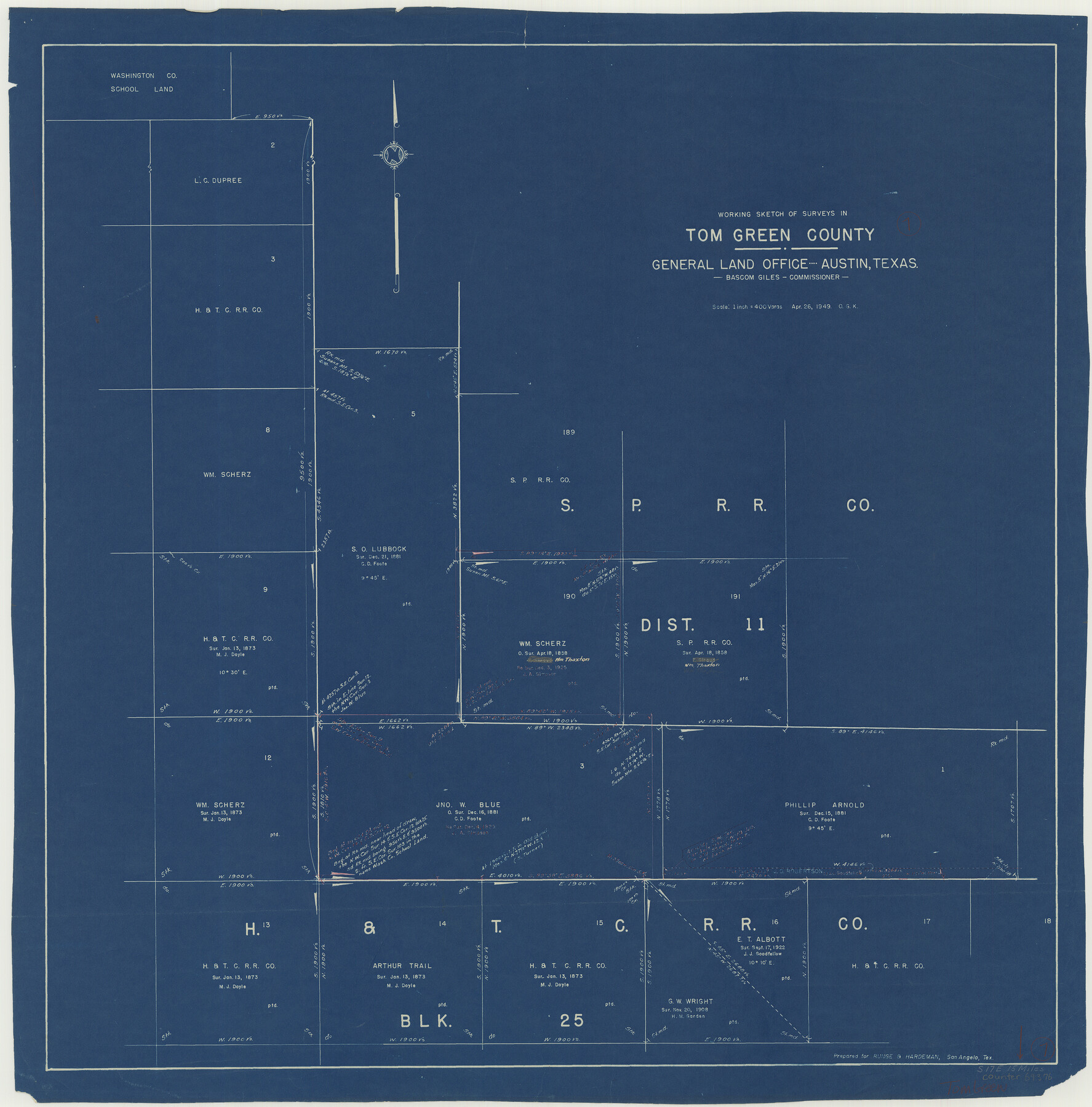
Tom Green County Working Sketch 7
-
Map/Doc
69376
-
Collection
General Map Collection
-
Object Dates
4/26/1949 (Creation Date)
-
People and Organizations
Otto G. Kurio (Draftsman)
-
Counties
Tom Green
-
Subjects
Surveying Working Sketch
-
Height x Width
32.2 x 31.7 inches
81.8 x 80.5 cm
-
Scale
1" = 400 varas
Part of: General Map Collection
Real County Working Sketch 84

Print $20.00
- Digital $50.00
Real County Working Sketch 84
1986
Size 25.0 x 40.7 inches
Map/Doc 71976
Presidio County Rolled Sketch 131A

Print $20.00
- Digital $50.00
Presidio County Rolled Sketch 131A
1992
Size 36.5 x 46.7 inches
Map/Doc 9802
Brewster County Working Sketch 113

Print $20.00
- Digital $50.00
Brewster County Working Sketch 113
1982
Size 29.4 x 38.2 inches
Map/Doc 67713
Brown County Working Sketch 7

Print $20.00
- Digital $50.00
Brown County Working Sketch 7
1954
Size 26.5 x 28.7 inches
Map/Doc 67772
Archer County Sketch File 30

Print $40.00
- Digital $50.00
Archer County Sketch File 30
1896
Size 20.6 x 18.5 inches
Map/Doc 10838
Midland County Working Sketch 34

Print $20.00
- Digital $50.00
Midland County Working Sketch 34
1983
Size 42.2 x 38.3 inches
Map/Doc 71015
McMullen County Sketch File 25a

Print $22.00
- Digital $50.00
McMullen County Sketch File 25a
1877
Size 8.8 x 12.9 inches
Map/Doc 31386
Padre Island National Seashore

Print $4.00
- Digital $50.00
Padre Island National Seashore
Size 16.2 x 22.1 inches
Map/Doc 60530
Wheeler County Boundary File 1a

Print $2.00
- Digital $50.00
Wheeler County Boundary File 1a
Size 12.8 x 8.8 inches
Map/Doc 59868
Flight Mission No. DCL-7C, Frame 18, Kenedy County

Print $20.00
- Digital $50.00
Flight Mission No. DCL-7C, Frame 18, Kenedy County
1943
Size 15.4 x 15.2 inches
Map/Doc 86010
Brewster County Sketch File 14

Print $26.00
- Digital $50.00
Brewster County Sketch File 14
Size 11.2 x 8.8 inches
Map/Doc 15746
Flight Mission No. CON-2R, Frame 55, Stonewall County

Print $20.00
- Digital $50.00
Flight Mission No. CON-2R, Frame 55, Stonewall County
1957
Size 18.3 x 22.0 inches
Map/Doc 86987
You may also like
Flight Mission No. DQO-1K, Frame 114, Galveston County

Print $20.00
- Digital $50.00
Flight Mission No. DQO-1K, Frame 114, Galveston County
1952
Size 18.8 x 22.5 inches
Map/Doc 84992
Jim Hogg County Boundary File 1

Print $16.00
- Digital $50.00
Jim Hogg County Boundary File 1
Size 11.4 x 8.8 inches
Map/Doc 55519
Nolan County Sketch File 9

Print $26.00
- Digital $50.00
Nolan County Sketch File 9
1902
Size 14.3 x 9.0 inches
Map/Doc 32465
[Sketch for Mineral Application 36425 - Jefferson County, Ley C. Moore]
![65615, [Sketch for Mineral Application 36425 - Jefferson County, Ley C. Moore], General Map Collection](https://historictexasmaps.com/wmedia_w700/maps/65615.tif.jpg)
Print $40.00
- Digital $50.00
[Sketch for Mineral Application 36425 - Jefferson County, Ley C. Moore]
1942
Size 35.0 x 49.3 inches
Map/Doc 65615
[Section 114, Block Z2]
![90371, [Section 114, Block Z2], Twichell Survey Records](https://historictexasmaps.com/wmedia_w700/maps/90371-1.tif.jpg)
Print $2.00
- Digital $50.00
[Section 114, Block Z2]
1907
Size 8.9 x 10.1 inches
Map/Doc 90371
Sutton County Working Sketch 50

Print $20.00
- Digital $50.00
Sutton County Working Sketch 50
1955
Size 27.4 x 22.2 inches
Map/Doc 62393
Wise County Sketch File 32

Print $5.00
- Digital $50.00
Wise County Sketch File 32
1880
Size 16.4 x 11.0 inches
Map/Doc 40588
[Surveys along the Texas coast across from Mustang Island]
![346, [Surveys along the Texas coast across from Mustang Island], General Map Collection](https://historictexasmaps.com/wmedia_w700/maps/346.tif.jpg)
Print $2.00
- Digital $50.00
[Surveys along the Texas coast across from Mustang Island]
1841
Size 11.3 x 7.3 inches
Map/Doc 346
Tom Green County Rolled Sketch 9

Print $20.00
- Digital $50.00
Tom Green County Rolled Sketch 9
1949
Size 32.2 x 41.0 inches
Map/Doc 9999
Flight Mission No. DAG-24K, Frame 161, Matagorda County

Print $20.00
- Digital $50.00
Flight Mission No. DAG-24K, Frame 161, Matagorda County
1953
Size 18.6 x 22.5 inches
Map/Doc 86575
Navarro County Working Sketch 11

Print $40.00
- Digital $50.00
Navarro County Working Sketch 11
1978
Size 53.7 x 44.4 inches
Map/Doc 71241
