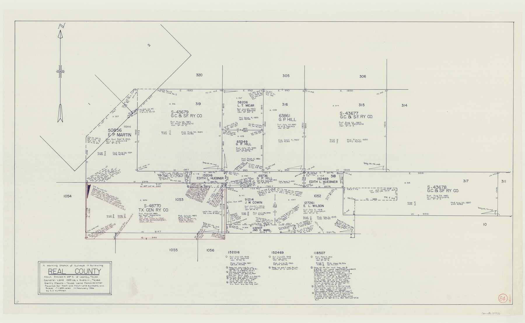
Real County Working Sketch 84
-
Map/Doc
71976
-
Collection
General Map Collection
-
Object Dates
2/14/1986 (Creation Date)
-
People and Organizations
C.J. Huffman (Draftsman)
-
Counties
Real
-
Subjects
Surveying Working Sketch
-
Height x Width
25.0 x 40.7 inches
63.5 x 103.4 cm
-
Scale
1" = 300 varas
Part of: General Map Collection
Deaf Smith County Working Sketch 1

Print $20.00
- Digital $50.00
Deaf Smith County Working Sketch 1
1919
Size 27.3 x 14.7 inches
Map/Doc 68641

Montague County Working Sketch 22

Print $20.00
- Digital $50.00
Montague County Working Sketch 22
1952
Size 29.5 x 24.6 inches
Map/Doc 71088
Real County Sketch File 5

Print $20.00
- Digital $50.00
Real County Sketch File 5
Size 16.9 x 20.9 inches
Map/Doc 12228
San Jacinto River and Tributaries, Texas - Survey of 1939

Print $20.00
- Digital $50.00
San Jacinto River and Tributaries, Texas - Survey of 1939
1939
Size 28.1 x 40.5 inches
Map/Doc 3153
Ride the Texas Independence Trail [Recto]
![94166, Ride the Texas Independence Trail [Recto], General Map Collection](https://historictexasmaps.com/wmedia_w700/maps/94166.tif.jpg)
Ride the Texas Independence Trail [Recto]
1968
Size 18.4 x 24.5 inches
Map/Doc 94166
Flight Mission No. CGI-4N, Frame 194, Cameron County

Print $20.00
- Digital $50.00
Flight Mission No. CGI-4N, Frame 194, Cameron County
1955
Size 15.6 x 22.1 inches
Map/Doc 84697
Martin County Sketch File 6

Print $4.00
- Digital $50.00
Martin County Sketch File 6
1914
Size 7.3 x 8.9 inches
Map/Doc 30642
Flight Mission No. DIX-3P, Frame 167, Aransas County

Print $20.00
- Digital $50.00
Flight Mission No. DIX-3P, Frame 167, Aransas County
1956
Size 17.8 x 18.0 inches
Map/Doc 83773
Flight Mission No. DQO-3K, Frame 16, Galveston County

Print $20.00
- Digital $50.00
Flight Mission No. DQO-3K, Frame 16, Galveston County
1952
Size 18.9 x 22.5 inches
Map/Doc 85057
Carte d'un Nouveau Monde, entre le Nouveau Mexique, et la Mer Glacialle

Print $20.00
- Digital $50.00
Carte d'un Nouveau Monde, entre le Nouveau Mexique, et la Mer Glacialle
1698
Size 11.5 x 18.1 inches
Map/Doc 96555
Crockett County Working Sketch 62

Print $40.00
- Digital $50.00
Crockett County Working Sketch 62
1956
Size 35.4 x 66.1 inches
Map/Doc 63760
You may also like
Falls County Sketch File 11a

Print $8.00
- Digital $50.00
Falls County Sketch File 11a
1871
Size 12.9 x 8.2 inches
Map/Doc 22358
Burleson County Working Sketch 13

Print $40.00
- Digital $50.00
Burleson County Working Sketch 13
1980
Size 49.2 x 34.6 inches
Map/Doc 67732
Callahan County

Print $20.00
- Digital $50.00
Callahan County
1879
Size 22.0 x 17.9 inches
Map/Doc 3362
Hardin County Sketch File 53

Print $12.00
- Digital $50.00
Hardin County Sketch File 53
Size 11.4 x 8.8 inches
Map/Doc 25213
Menard County Boundary File 3a

Print $4.00
- Digital $50.00
Menard County Boundary File 3a
Size 10.6 x 8.1 inches
Map/Doc 57074
Hamilton County Working Sketch 5

Print $20.00
- Digital $50.00
Hamilton County Working Sketch 5
1941
Size 25.5 x 20.1 inches
Map/Doc 63343
Amistad International Reservoir on Rio Grande 82

Print $20.00
- Digital $50.00
Amistad International Reservoir on Rio Grande 82
1949
Size 28.5 x 40.2 inches
Map/Doc 75511
Gillespie County Working Sketch Graphic Index

Print $20.00
- Digital $50.00
Gillespie County Working Sketch Graphic Index
1945
Size 38.0 x 47.4 inches
Map/Doc 76553
Jasper County

Print $40.00
- Digital $50.00
Jasper County
1898
Size 65.1 x 37.4 inches
Map/Doc 82048
Stonewall County Rolled Sketch 10

Print $20.00
- Digital $50.00
Stonewall County Rolled Sketch 10
Size 22.3 x 29.6 inches
Map/Doc 7866
Portion of States Submerged Area in Matagorda Bay

Print $20.00
- Digital $50.00
Portion of States Submerged Area in Matagorda Bay
1922
Size 13.9 x 15.9 inches
Map/Doc 2951
Wood County Sketch File 11

Print $4.00
- Digital $50.00
Wood County Sketch File 11
1858
Size 12.7 x 8.0 inches
Map/Doc 40664