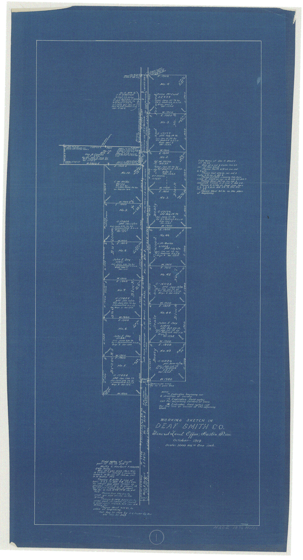
Deaf Smith County Working Sketch 1
-
Map/Doc
68641
-
Collection
General Map Collection
-
Object Dates
10/1919 (Creation Date)
-
Counties
Deaf Smith
-
Subjects
Surveying Working Sketch
-
Height x Width
27.3 x 14.7 inches
69.3 x 37.3 cm
-
Scale
1" = 1000 varas
Part of: General Map Collection
Starr County Sketch File 45

Print $6.00
- Digital $50.00
Starr County Sketch File 45
1945
Size 14.3 x 8.7 inches
Map/Doc 36999
Angelina River, Mud Creek, Sheet 4

Print $4.00
- Digital $50.00
Angelina River, Mud Creek, Sheet 4
1937
Size 25.4 x 18.5 inches
Map/Doc 65078
Terrell County Working Sketch 54

Print $20.00
- Digital $50.00
Terrell County Working Sketch 54
1959
Size 25.2 x 42.9 inches
Map/Doc 62147
Flight Mission No. DCL-5C, Frame 4, Kenedy County

Print $20.00
- Digital $50.00
Flight Mission No. DCL-5C, Frame 4, Kenedy County
1943
Size 18.6 x 22.5 inches
Map/Doc 85829
Travis County Appraisal District Plat Map 4_1301

Print $20.00
- Digital $50.00
Travis County Appraisal District Plat Map 4_1301
Size 21.5 x 26.4 inches
Map/Doc 94213
Cass County Sketch File 9

Print $4.00
- Digital $50.00
Cass County Sketch File 9
1857
Size 8.0 x 13.1 inches
Map/Doc 17410
Van Zandt County Sketch File 20a

Print $4.00
- Digital $50.00
Van Zandt County Sketch File 20a
1858
Size 12.9 x 8.0 inches
Map/Doc 39428
Flight Mission No. CUG-3P, Frame 42, Kleberg County

Print $20.00
- Digital $50.00
Flight Mission No. CUG-3P, Frame 42, Kleberg County
1956
Size 18.5 x 22.1 inches
Map/Doc 86247
Pecos County Sketch File 106

Print $6.00
- Digital $50.00
Pecos County Sketch File 106
1967
Size 14.2 x 8.8 inches
Map/Doc 34030
Cherokee County Sketch File 23

Print $20.00
- Digital $50.00
Cherokee County Sketch File 23
1922
Size 12.8 x 18.5 inches
Map/Doc 11073
Jefferson County Sketch File 44

Print $20.00
- Digital $50.00
Jefferson County Sketch File 44
1917
Size 22.8 x 32.9 inches
Map/Doc 11878
[Sketch for Mineral Application 19144 - Pecos River Bed]
![65573, [Sketch for Mineral Application 19144 - Pecos River Bed], General Map Collection](https://historictexasmaps.com/wmedia_w700/maps/65573.tif.jpg)
Print $20.00
- Digital $50.00
[Sketch for Mineral Application 19144 - Pecos River Bed]
1927
Size 45.2 x 46.4 inches
Map/Doc 65573
You may also like

Colorado County Working Sketch 30

Print $20.00
- Digital $50.00
Colorado County Working Sketch 30
1980
Size 22.2 x 19.8 inches
Map/Doc 68130
Township 6 North Range 13 West, North Western District, Louisiana

Print $20.00
- Digital $50.00
Township 6 North Range 13 West, North Western District, Louisiana
1841
Size 19.7 x 24.8 inches
Map/Doc 65864
Travis County Sketch File 76

Print $68.00
- Digital $50.00
Travis County Sketch File 76
1996
Size 11.4 x 8.9 inches
Map/Doc 38474
Hunt County Sketch File 34a

Print $4.00
- Digital $50.00
Hunt County Sketch File 34a
1873
Size 8.0 x 10.1 inches
Map/Doc 27146
Matagorda County Sketch File 10

Print $26.00
- Digital $50.00
Matagorda County Sketch File 10
Size 8.3 x 5.2 inches
Map/Doc 30755
Brewster County Rolled Sketch 105

Print $20.00
- Digital $50.00
Brewster County Rolled Sketch 105
Size 27.2 x 24.5 inches
Map/Doc 5257
[Connecting lines through Blocks A2, 29, I, GG, I. & G. N. Block 1 and Archer County School Land]
![91645, [Connecting lines through Blocks A2, 29, I, GG, I. & G. N. Block 1 and Archer County School Land], Twichell Survey Records](https://historictexasmaps.com/wmedia_w700/maps/91645-1.tif.jpg)
Print $20.00
- Digital $50.00
[Connecting lines through Blocks A2, 29, I, GG, I. & G. N. Block 1 and Archer County School Land]
Size 22.4 x 16.9 inches
Map/Doc 91645
Upton County Sketch File 45

Print $20.00
- Digital $50.00
Upton County Sketch File 45
1994
Size 11.3 x 8.8 inches
Map/Doc 38933
Winkler County Rolled Sketch 10

Print $40.00
- Digital $50.00
Winkler County Rolled Sketch 10
1958
Size 29.4 x 55.9 inches
Map/Doc 10151
Panola County Working Sketch 10

Print $20.00
- Digital $50.00
Panola County Working Sketch 10
1943
Map/Doc 71419
[Plat Showing San Gabriel & 24th Street Intersection, Outlot 4, Travis County, Texas]
![75795, [Plat Showing San Gabriel & 24th Street Intersection, Outlot 4, Travis County, Texas], Maddox Collection](https://historictexasmaps.com/wmedia_w700/maps/75795.tif.jpg)
Print $2.00
- Digital $50.00
[Plat Showing San Gabriel & 24th Street Intersection, Outlot 4, Travis County, Texas]
Size 11.4 x 8.7 inches
Map/Doc 75795