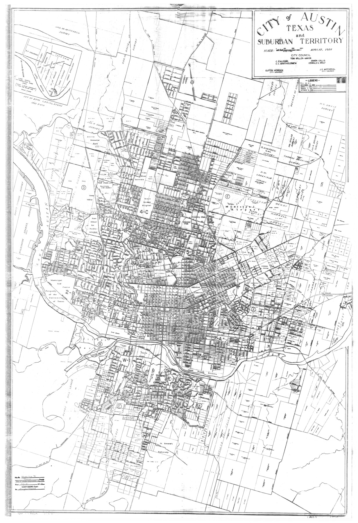
Travis County Sketch File 76
[AG Opinion, memo and city ordinance regarding location of Austin city limits and extent of city ownership of Colorado River bed]
-
Map/Doc
38474
-
Collection
General Map Collection
-
Object Dates
7/31/1996 (Creation Date)
7/31/1996 (File Date)
8/1937 (Creation Date)
7/31/1996 (Correspondence Date)
10/2/1951 (Correspondence Date)
-
Counties
Travis
-
Subjects
Surveying Sketch File
-
Height x Width
11.4 x 8.9 inches
29.0 x 22.6 cm
-
Medium
paper, print
-
Features
Dawson Addition
Johnson Addition
Tobin Addition
Forrest Avenue
Walsh Place
Austin Dam
Rabb Home
Barton Springs Addition
McKinney Avenue
Evergreen Heights
Leland Street
J.E. Bouldin Addition
Exposition Boulevard
Davis Addition
S. 1st Street
Bouldin Creek
Breckenridge Road
Live Oak Grove Addition
Wilson Street
Grand Courts
Post Road
Pleasant View Addition
Blum Creek
Burleson Road
Staehely Addition
A&NW
MP
Southern Pacific Railroad Company
I&GN
MK&TE
H&TC
I&GN
Chestnut Street
Manor Road
Earnest Avenue
42nd Street
Travis Heights
Spreckles Addition
Ridgetop Annex
Guadalupe Street
Alta Vista Addition
Morningside Avenue
45th Street
Alice Avenue
Lewis Hancock Subdivision
Military Heights
Burns Street
Westfield Addition
State Blind Institute
Oakwood Cemetery Annex
State Cemetery
Bethany Cemetery
Evergreen Cemetery
Mount Calvary Cemetery
University of Texas
Municipal Golf Course
Lake Austin
Camp Mabry
State Deaf, Dumb & Blind Institute (for Colored)
Austin Memorial Park Cemetery
Tillotson Institute
Georgetown Road
Cameron Road
Little Walnut Creek
Bull Creek
[Road] to Bull Creek
Lake Austin Metropolitan Park
Lake Austin
University Airport
Middle Fiskville Road
Road to G[eorge]t[own] & Taylor
Road to G[eorge]t[own]
Road to Manchaca
Bellevue Park Addition
Summit Street
Govalle
Webberville Road
Rosewood Avenue
E. 12th Street
E. 19th Street
Rosewood Avenue
Manor Road
Austin Memorial Park Cemetery
St. Edward's University
Road to Jollyville
State Hwy. 20 to Fredericksburg
Barton Creek
Texas State School for the Deaf
Old Bastrop Road
State Hiway [sic] 21 to Bastrop
Barton Springs
Road to Bee Caves
Zilker Park
Deep Eddy
Colorado River
Part of: General Map Collection
Southern Part of Laguna Madre

Print $20.00
- Digital $50.00
Southern Part of Laguna Madre
1987
Size 44.5 x 34.7 inches
Map/Doc 73548
Outer Continental Shelf Leasing Maps (Louisiana Offshore Operations)

Print $20.00
- Digital $50.00
Outer Continental Shelf Leasing Maps (Louisiana Offshore Operations)
1954
Size 25.5 x 15.3 inches
Map/Doc 76093
Flight Mission No. CLL-3N, Frame 33, Willacy County

Print $20.00
- Digital $50.00
Flight Mission No. CLL-3N, Frame 33, Willacy County
1954
Size 18.6 x 22.3 inches
Map/Doc 87090
Montgomery County Rolled Sketch 42

Print $20.00
- Digital $50.00
Montgomery County Rolled Sketch 42
1939
Size 14.1 x 20.1 inches
Map/Doc 6818
Runnels County Working Sketch 12

Print $20.00
- Digital $50.00
Runnels County Working Sketch 12
1950
Size 27.7 x 33.0 inches
Map/Doc 63608
Jim Wells County Boundary File 1

Print $22.00
- Digital $50.00
Jim Wells County Boundary File 1
Size 8.9 x 4.3 inches
Map/Doc 55531
Wise County Sketch File 30

Print $6.00
- Digital $50.00
Wise County Sketch File 30
1876
Size 12.7 x 8.1 inches
Map/Doc 40579
Hall County Sketch File 15

Print $6.00
- Digital $50.00
Hall County Sketch File 15
Size 5.7 x 16.9 inches
Map/Doc 24814
Flight Mission No. DQN-1K, Frame 154, Calhoun County

Print $20.00
- Digital $50.00
Flight Mission No. DQN-1K, Frame 154, Calhoun County
1953
Size 18.7 x 22.4 inches
Map/Doc 84213
Harris County Sketch File 95

Print $20.00
- Digital $50.00
Harris County Sketch File 95
1952
Size 31.6 x 17.1 inches
Map/Doc 11678
Carson County

Print $20.00
- Digital $50.00
Carson County
1932
Size 42.0 x 38.5 inches
Map/Doc 73100
Hunt County Rolled Sketch 5

Print $20.00
- Digital $50.00
Hunt County Rolled Sketch 5
1966
Size 24.7 x 24.4 inches
Map/Doc 6273
You may also like
Brewster County Working Sketch 2

Print $20.00
- Digital $50.00
Brewster County Working Sketch 2
1907
Size 29.0 x 26.4 inches
Map/Doc 67535
Working Sketch in Wheeler County

Print $20.00
- Digital $50.00
Working Sketch in Wheeler County
1910
Size 7.0 x 39.5 inches
Map/Doc 90731
Harris County Sketch File A

Print $4.00
- Digital $50.00
Harris County Sketch File A
1898
Size 12.8 x 8.5 inches
Map/Doc 25306

Brewster County Rolled Sketch 152

Print $20.00
- Digital $50.00
Brewster County Rolled Sketch 152
1996
Size 28.0 x 36.5 inches
Map/Doc 5319
Nueces County Sketch File 8

Print $22.00
- Digital $50.00
Nueces County Sketch File 8
1849
Size 8.2 x 12.4 inches
Map/Doc 32512
Williamson County Sketch File 6

Print $4.00
- Digital $50.00
Williamson County Sketch File 6
1848
Size 12.8 x 8.1 inches
Map/Doc 40314
Terrell County Sketch File 12

Print $4.00
- Digital $50.00
Terrell County Sketch File 12
1903
Size 5.7 x 8.5 inches
Map/Doc 37922
Brazoria County NRC Article 33.136 Sketch 28

Print $24.00
Brazoria County NRC Article 33.136 Sketch 28
2025
Map/Doc 97473
Martin County Rolled Sketch 10

Print $20.00
- Digital $50.00
Martin County Rolled Sketch 10
1994
Size 18.4 x 24.2 inches
Map/Doc 6670
Flight Mission No. CZW-2R, Frame 25, Hardeman County

Print $20.00
- Digital $50.00
Flight Mission No. CZW-2R, Frame 25, Hardeman County
1956
Size 18.7 x 22.4 inches
Map/Doc 85237
[Location, Fort Worth & Denver Railroad, through Wilbarger County]
![64344, [Location, Fort Worth & Denver Railroad, through Wilbarger County], General Map Collection](https://historictexasmaps.com/wmedia_w700/maps/64344.tif.jpg)
Print $40.00
- Digital $50.00
[Location, Fort Worth & Denver Railroad, through Wilbarger County]
Size 20.8 x 123.5 inches
Map/Doc 64344