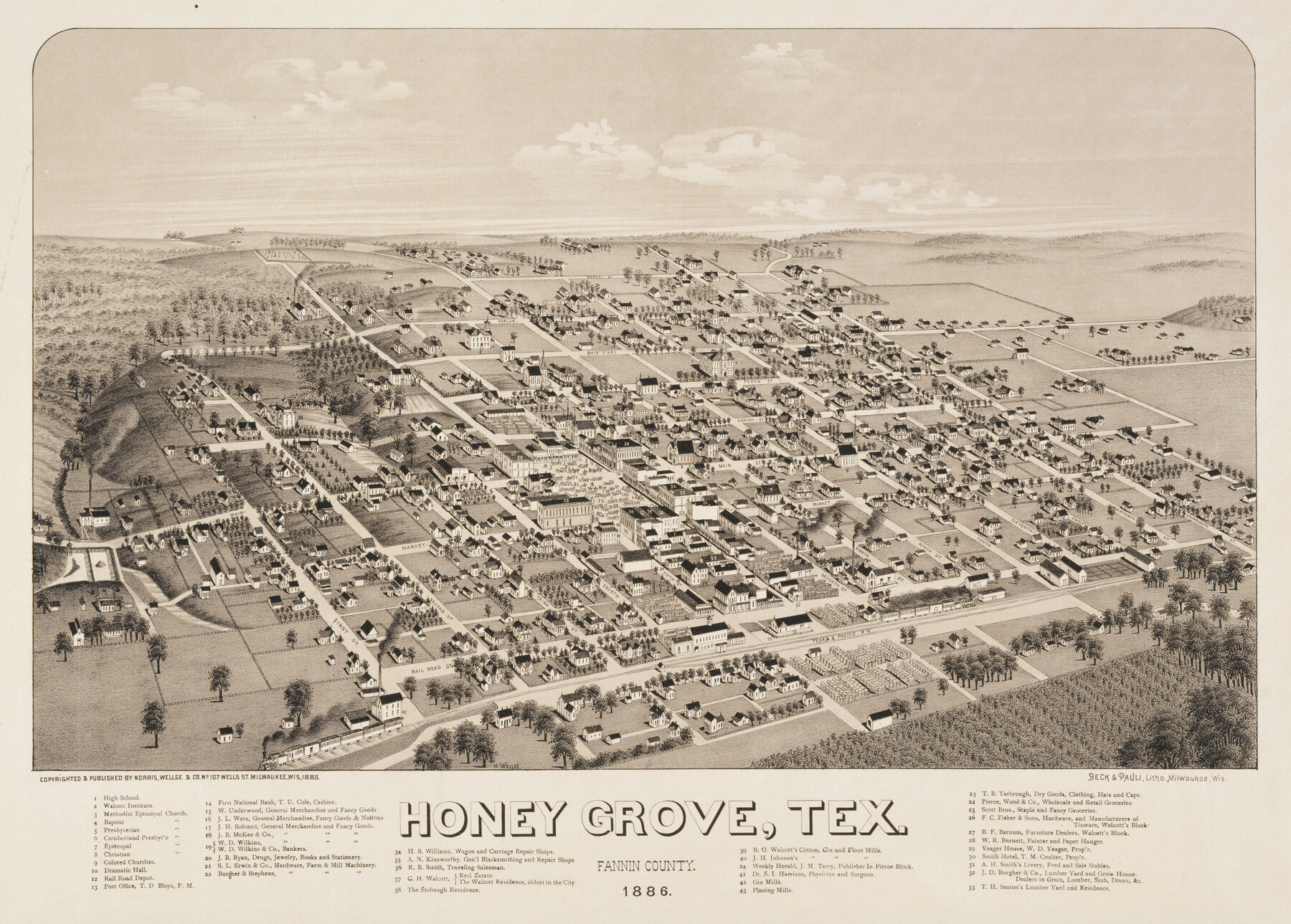
Honey Grove, Tex., Fannin County, 1886
-
Map/Doc
89091
-
Collection
Non-GLO Digital Images
-
Object Dates
1886 (Creation Date)
-
People and Organizations
Norris, Wellge and Company (Publisher)
Beck and Pauli Lithographers (Printer)
Henry Wellge (Draftsman)
-
Counties
Fannin
-
Subjects
Bird's Eye View City Pictorial
-
Height x Width
15.9 x 22.2 inches
40.4 x 56.4 cm
-
Comments
Bird's Eye View map. Public Domain image obtained from Wikimedia Commons.
Part of: Non-GLO Digital Images

The Official Map of the City of El Paso, State of Texas

Print $20.00
The Official Map of the City of El Paso, State of Texas
1889
Size 42.4 x 54.4 inches
Map/Doc 89617
A Map of the United States of Mexico as organized and defined by the several Acts of the Congress of that Republic

Print $20.00
A Map of the United States of Mexico as organized and defined by the several Acts of the Congress of that Republic
1826
Size 23.2 x 28.9 inches
Map/Doc 93635
[Movements & Objectives of the 143rd & 144th Infantry on October 13, 1918, Appendix L]
![94124, [Movements & Objectives of the 143rd & 144th Infantry on October 13, 1918, Appendix L], Non-GLO Digital Images](https://historictexasmaps.com/wmedia_w700/maps/94124-1.tif.jpg)
Print $20.00
[Movements & Objectives of the 143rd & 144th Infantry on October 13, 1918, Appendix L]
1918
Size 16.1 x 16.8 inches
Map/Doc 94124
Descripción y Mapa de la Nueva Provincia, poblada de Bárbaros, situada en la Costa del Seno Mexicano, desde el puerto de Tampico hasta la Provincia de Texas

Descripción y Mapa de la Nueva Provincia, poblada de Bárbaros, situada en la Costa del Seno Mexicano, desde el puerto de Tampico hasta la Provincia de Texas
1744
Size 32.0 x 29.1 inches
Map/Doc 94558
[WWI Topographic Planning Map of the Ardennes department] - Verso
![94130, [WWI Topographic Planning Map of the Ardennes department] - Verso, Non-GLO Digital Images](https://historictexasmaps.com/wmedia_w700/maps/94130-1.tif.jpg)
Print $20.00
[WWI Topographic Planning Map of the Ardennes department] - Verso
1918
Size 35.9 x 20.4 inches
Map/Doc 94130
Plano de la Sauteña. Indicando los terrenos irrigados en Texas

Plano de la Sauteña. Indicando los terrenos irrigados en Texas
Size 38.6 x 37.8 inches
Map/Doc 94566
Fort Worth, Tex. "The Queen of the Prairies," County Seat of Tarrant County

Print $20.00
Fort Worth, Tex. "The Queen of the Prairies," County Seat of Tarrant County
1886
Size 26.0 x 33.3 inches
Map/Doc 89082
Map of Colorado City on the west bank of the Colorado River at the La Bahia crossing

Print $20.00
Map of Colorado City on the west bank of the Colorado River at the La Bahia crossing
1841
Size 24.4 x 32.5 inches
Map/Doc 94750

The Official Map of the City of El Paso, State of Texas

Print $20.00
The Official Map of the City of El Paso, State of Texas
1889
Size 41.9 x 46.2 inches
Map/Doc 89618
La Louisiane, Suivant les Nouvelles Observations de Messrs de l'Academie Royale des Sciences

Print $20.00
La Louisiane, Suivant les Nouvelles Observations de Messrs de l'Academie Royale des Sciences
1735
Size 9.1 x 11.9 inches
Map/Doc 95279
You may also like
Brewster County Sketch File N-21

Print $40.00
- Digital $50.00
Brewster County Sketch File N-21
1951
Size 18.0 x 18.6 inches
Map/Doc 10968
Denton County

Print $20.00
- Digital $50.00
Denton County
1947
Size 43.4 x 39.9 inches
Map/Doc 95480
Flight Mission No. BQR-9K, Frame 47, Brazoria County

Print $20.00
- Digital $50.00
Flight Mission No. BQR-9K, Frame 47, Brazoria County
1952
Size 18.7 x 22.4 inches
Map/Doc 84051
Kendall County Working Sketch 16

Print $20.00
- Digital $50.00
Kendall County Working Sketch 16
1967
Size 28.0 x 29.1 inches
Map/Doc 66688
Hidalgo County Sketch File 7

Print $20.00
- Digital $50.00
Hidalgo County Sketch File 7
1882
Size 20.3 x 28.2 inches
Map/Doc 11761
Montgomery County Rolled Sketch 32

Print $40.00
- Digital $50.00
Montgomery County Rolled Sketch 32
1949
Size 59.9 x 40.4 inches
Map/Doc 9540
Map of the County and City of Galveston, Texas

Print $20.00
Map of the County and City of Galveston, Texas
1891
Size 24.5 x 34.4 inches
Map/Doc 79290
Childress County Sketch File 18

Print $8.00
- Digital $50.00
Childress County Sketch File 18
1909
Size 14.3 x 9.0 inches
Map/Doc 18290
Travis County Working Sketch 23

Print $20.00
- Digital $50.00
Travis County Working Sketch 23
1947
Size 23.1 x 30.1 inches
Map/Doc 69407
Hudspeth County Sketch File 4a

Print $22.00
- Digital $50.00
Hudspeth County Sketch File 4a
1858
Size 16.4 x 14.3 inches
Map/Doc 26889
Dimmit County Working Sketch 42

Print $20.00
- Digital $50.00
Dimmit County Working Sketch 42
1977
Size 33.5 x 39.6 inches
Map/Doc 68703
Hansford County

Print $20.00
- Digital $50.00
Hansford County
1889
Size 22.9 x 18.5 inches
Map/Doc 3624