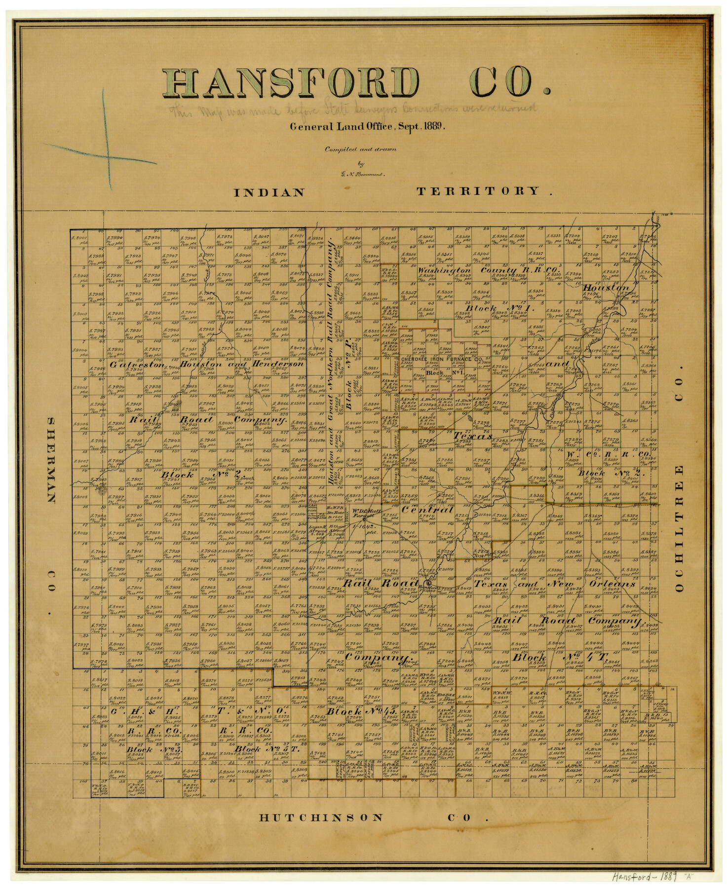
Hansford County
-
Map/Doc
3624
-
Collection
General Map Collection
-
Object Dates
9/1889 (Creation Date)
-
People and Organizations
Texas General Land Office (Publisher)
G.N. Beaumont (Draftsman)
G.N. Beaumont (Compiler)
-
Counties
Hansford
-
Subjects
County
-
Height x Width
22.9 x 18.5 inches
58.2 x 47.0 cm
-
Comments
This "A" map was made before State Surveyors connections were returned.
-
Features
Rabbits [sic] Ear Creek
Paladoras Creek
Farwell
Hansford
Part of: General Map Collection
Jefferson County Rolled Sketch 41

Print $20.00
- Digital $50.00
Jefferson County Rolled Sketch 41
1897
Size 25.1 x 17.8 inches
Map/Doc 6399
Baylor County Sketch File A1

Print $40.00
- Digital $50.00
Baylor County Sketch File A1
1899
Size 22.8 x 17.3 inches
Map/Doc 10911

Travis County Working Sketch 47

Print $40.00
- Digital $50.00
Travis County Working Sketch 47
1981
Size 55.5 x 41.8 inches
Map/Doc 69431
Travis County Rolled Sketch 34

Print $20.00
- Digital $50.00
Travis County Rolled Sketch 34
1949
Size 22.9 x 25.2 inches
Map/Doc 8035
Trinity River, Wildcat Ferry Sheet

Print $20.00
- Digital $50.00
Trinity River, Wildcat Ferry Sheet
1928
Size 41.5 x 40.9 inches
Map/Doc 65182
Old Miscellaneous File 23

Print $58.00
- Digital $50.00
Old Miscellaneous File 23
1919
Size 14.2 x 8.6 inches
Map/Doc 75600
Lavaca County Sketch File 4

Print $6.00
- Digital $50.00
Lavaca County Sketch File 4
Size 8.2 x 15.3 inches
Map/Doc 29636
Flight Mission No. DQO-7K, Frame 103, Galveston County

Print $20.00
- Digital $50.00
Flight Mission No. DQO-7K, Frame 103, Galveston County
1952
Size 18.5 x 22.7 inches
Map/Doc 85118
Plano General de los Ferrocarriles Nacionales de Mexico, F.C. Internacional Mexicano, F.C. Interoceanico de Mexico, F.C. Mexicano del sur y sus Conexiones

Print $20.00
- Digital $50.00
Plano General de los Ferrocarriles Nacionales de Mexico, F.C. Internacional Mexicano, F.C. Interoceanico de Mexico, F.C. Mexicano del sur y sus Conexiones
1910
Size 27.8 x 32.5 inches
Map/Doc 95743
Plat of Proposed County

Print $20.00
- Digital $50.00
Plat of Proposed County
1909
Size 23.9 x 30.8 inches
Map/Doc 1712
Denton County Sketch File 27

Print $4.00
- Digital $50.00
Denton County Sketch File 27
1858
Size 7.9 x 12.1 inches
Map/Doc 20754
You may also like
Reagan County Working Sketch 19

Print $20.00
- Digital $50.00
Reagan County Working Sketch 19
1954
Size 24.3 x 42.9 inches
Map/Doc 71861
Shallowater Well Field Survey

Print $40.00
- Digital $50.00
Shallowater Well Field Survey
Size 61.8 x 43.7 inches
Map/Doc 89900
Terry County Sketch File 14

Print $20.00
- Digital $50.00
Terry County Sketch File 14
Size 11.1 x 42.4 inches
Map/Doc 10398
Jack County Sketch File 12

Print $9.00
- Digital $50.00
Jack County Sketch File 12
Size 5.6 x 8.3 inches
Map/Doc 27533
Flight Mission No. DAG-22K, Frame 81, Matagorda County

Print $20.00
- Digital $50.00
Flight Mission No. DAG-22K, Frame 81, Matagorda County
1953
Size 18.6 x 22.4 inches
Map/Doc 86465
Kerr County Sketch File 22

Print $8.00
- Digital $50.00
Kerr County Sketch File 22
Size 11.3 x 8.7 inches
Map/Doc 28897
Flight Mission No. DAH-9M, Frame 197, Orange County

Print $20.00
- Digital $50.00
Flight Mission No. DAH-9M, Frame 197, Orange County
1953
Size 18.5 x 22.4 inches
Map/Doc 86865
Karnes County Working Sketch 5

Print $20.00
- Digital $50.00
Karnes County Working Sketch 5
1960
Size 37.2 x 36.8 inches
Map/Doc 66653
Montgomery County Working Sketch 64

Print $20.00
- Digital $50.00
Montgomery County Working Sketch 64
1965
Size 27.9 x 33.7 inches
Map/Doc 71171
Liberty County Working Sketch 61

Print $20.00
- Digital $50.00
Liberty County Working Sketch 61
1969
Size 43.3 x 32.0 inches
Map/Doc 70521
Kerr County Working Sketch 28

Print $20.00
- Digital $50.00
Kerr County Working Sketch 28
1971
Size 38.5 x 39.1 inches
Map/Doc 70059
Flight Mission No. DQO-6K, Frame 31, Galveston County

Print $20.00
- Digital $50.00
Flight Mission No. DQO-6K, Frame 31, Galveston County
1952
Size 18.5 x 22.4 inches
Map/Doc 85097