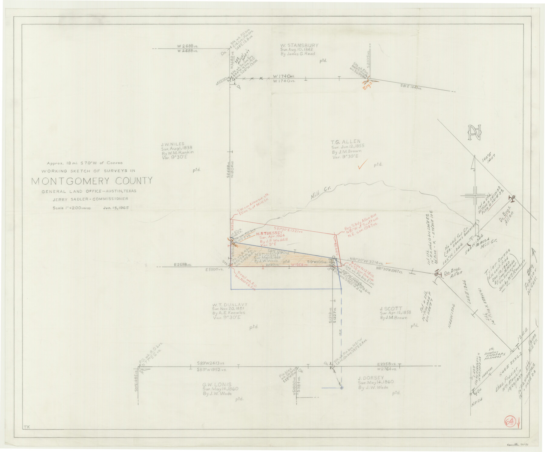
Montgomery County Working Sketch 64
-
Map/Doc
71171
-
Collection
General Map Collection
-
Object Dates
6/15/1965 (Creation Date)
-
Counties
Montgomery
-
Subjects
Surveying Working Sketch
-
Height x Width
27.9 x 33.7 inches
70.9 x 85.6 cm
-
Scale
1" = 200 varas
Part of: General Map Collection
Flight Mission No. DQO-2K, Frame 145, Galveston County

Print $20.00
- Digital $50.00
Flight Mission No. DQO-2K, Frame 145, Galveston County
1952
Size 18.8 x 22.5 inches
Map/Doc 85042
Fisher County Sketch File 21

Print $6.00
- Digital $50.00
Fisher County Sketch File 21
Size 10.3 x 17.0 inches
Map/Doc 22649
[Northern boundary line of McMullen's claim]
![313, [Northern boundary line of McMullen's claim], General Map Collection](https://historictexasmaps.com/wmedia_w700/maps/313.tif.jpg)
Print $2.00
- Digital $50.00
[Northern boundary line of McMullen's claim]
1847
Size 13.5 x 8.0 inches
Map/Doc 313

Jasper County Sketch File 8 and 9

Print $80.00
- Digital $50.00
Jasper County Sketch File 8 and 9
Size 8.2 x 6.9 inches
Map/Doc 27777
La Salle County Working Sketch 37

Print $20.00
- Digital $50.00
La Salle County Working Sketch 37
1960
Size 24.4 x 21.7 inches
Map/Doc 70338
La Salle County Rolled Sketch 12

Print $20.00
- Digital $50.00
La Salle County Rolled Sketch 12
Size 25.3 x 37.2 inches
Map/Doc 6575
Coast Chart No. 210 - Aransas Pass and Corpus Christi Bay with the coast to latitude 27° 12', Texas

Print $20.00
- Digital $50.00
Coast Chart No. 210 - Aransas Pass and Corpus Christi Bay with the coast to latitude 27° 12', Texas
1900
Size 18.3 x 23.6 inches
Map/Doc 73448

University and College Lands

Print $20.00
- Digital $50.00
University and College Lands
1841
Size 21.3 x 27.0 inches
Map/Doc 169
Burnet County Sketch File 10

Print $4.00
- Digital $50.00
Burnet County Sketch File 10
1848
Size 12.8 x 8.4 inches
Map/Doc 16690
Collin County Boundary File 18d

Print $20.00
- Digital $50.00
Collin County Boundary File 18d
Size 12.8 x 8.2 inches
Map/Doc 51739
You may also like
Flight Mission No. DQN-1K, Frame 81, Calhoun County

Print $20.00
- Digital $50.00
Flight Mission No. DQN-1K, Frame 81, Calhoun County
1953
Size 18.4 x 22.1 inches
Map/Doc 84166
Flight Mission No. BRA-3M, Frame 197, Jefferson County

Print $20.00
- Digital $50.00
Flight Mission No. BRA-3M, Frame 197, Jefferson County
1953
Size 18.6 x 22.4 inches
Map/Doc 85412
Leon County Working Sketch 6

Print $20.00
- Digital $50.00
Leon County Working Sketch 6
1905
Size 46.0 x 21.5 inches
Map/Doc 70405
Tarrant County Working Sketch 27

Print $20.00
- Digital $50.00
Tarrant County Working Sketch 27
2010
Size 19.4 x 35.9 inches
Map/Doc 89261
Cooke County Sketch File 2

Print $20.00
- Digital $50.00
Cooke County Sketch File 2
Size 9.6 x 21.6 inches
Map/Doc 11169
Montgomery County Working Sketch 65

Print $20.00
- Digital $50.00
Montgomery County Working Sketch 65
1965
Size 21.5 x 16.7 inches
Map/Doc 71172
[Plat of Trinity River w/ Midstream Profile in Liberty County by US Government 1899]
![65339, [Plat of Trinity River w/ Midstream Profile in Liberty County by US Government 1899], General Map Collection](https://historictexasmaps.com/wmedia_w700/maps/65339.tif.jpg)
Print $20.00
- Digital $50.00
[Plat of Trinity River w/ Midstream Profile in Liberty County by US Government 1899]
1899
Size 12.8 x 17.6 inches
Map/Doc 65339
Shackelford County

Print $20.00
- Digital $50.00
Shackelford County
1920
Size 39.2 x 46.1 inches
Map/Doc 93031
Glasscock County Working Sketch 8

Print $20.00
- Digital $50.00
Glasscock County Working Sketch 8
Size 42.7 x 10.3 inches
Map/Doc 62189
[Sketch for Mineral Application 21493 - Clay County]
![65626, [Sketch for Mineral Application 21493 - Clay County], General Map Collection](https://historictexasmaps.com/wmedia_w700/maps/65626-1.tif.jpg)
Print $40.00
- Digital $50.00
[Sketch for Mineral Application 21493 - Clay County]
Size 63.1 x 35.3 inches
Map/Doc 65626
![90327, [Block B9], Twichell Survey Records](https://historictexasmaps.com/wmedia_w700/maps/90327-1.tif.jpg)
Jasper County Working Sketch 17

Print $20.00
- Digital $50.00
Jasper County Working Sketch 17
1934
Size 18.1 x 24.2 inches
Map/Doc 66479