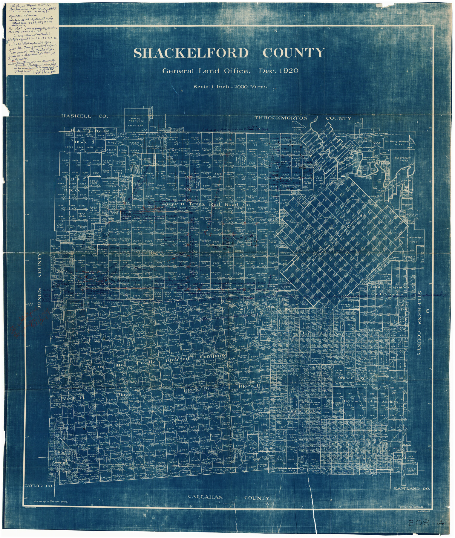
Shackelford County
209-14
-
Map/Doc
93031
-
Collection
Twichell Survey Records
-
Object Dates
12/1920 (Creation Date)
-
Counties
Shackelford
-
Subjects
County
-
Height x Width
39.2 x 46.1 inches
99.6 x 117.1 cm
Part of: Twichell Survey Records
[Sections 58-70, I. & G. N. Block 1, Runnels County School Land and part of Block 194]
![91632, [Sections 58-70, I. & G. N. Block 1, Runnels County School Land and part of Block 194], Twichell Survey Records](https://historictexasmaps.com/wmedia_w700/maps/91632-1.tif.jpg)
Print $20.00
- Digital $50.00
[Sections 58-70, I. & G. N. Block 1, Runnels County School Land and part of Block 194]
Size 23.9 x 20.9 inches
Map/Doc 91632
[Map of Block KS in Oldham County, Texas]
![90691, [Map of Block KS in Oldham County, Texas], Twichell Survey Records](https://historictexasmaps.com/wmedia_w700/maps/90691-1.tif.jpg)
Print $20.00
- Digital $50.00
[Map of Block KS in Oldham County, Texas]
1903
Size 20.6 x 23.2 inches
Map/Doc 90691
Rhoades Heights, North Part of West Half, Section 8, Block E

Print $20.00
- Digital $50.00
Rhoades Heights, North Part of West Half, Section 8, Block E
Size 29.2 x 13.5 inches
Map/Doc 92759
[Block AX and vicinity]
![90860, [Block AX and vicinity], Twichell Survey Records](https://historictexasmaps.com/wmedia_w700/maps/90860-2.tif.jpg)
Print $20.00
- Digital $50.00
[Block AX and vicinity]
Size 35.9 x 19.7 inches
Map/Doc 90860
[G. B. & C. Blocks K3 and K4]
![90512, [G. B. & C. Blocks K3 and K4], Twichell Survey Records](https://historictexasmaps.com/wmedia_w700/maps/90512-1.tif.jpg)
Print $20.00
- Digital $50.00
[G. B. & C. Blocks K3 and K4]
Size 14.0 x 14.5 inches
Map/Doc 90512

[William T. Brewer, John R. Taylor, M. McDonald, W. N. Raymond, and surrounding surveys]
![91031, [William T. Brewer, John R. Taylor, M. McDonald, W. N. Raymond, and surrounding surveys], Twichell Survey Records](https://historictexasmaps.com/wmedia_w700/maps/91031-1.tif.jpg)
Print $20.00
- Digital $50.00
[William T. Brewer, John R. Taylor, M. McDonald, W. N. Raymond, and surrounding surveys]
Size 29.1 x 25.5 inches
Map/Doc 91031
Plat Compiled by W.J. Williams, Plainview, Texas, and Sylvan Sanders, Lubbock, Texas Showing Position of Original and Re-Survey Corners in Lynn, Terry, Yoakum, Gaines, and Dawson Counties, Texas

Print $40.00
- Digital $50.00
Plat Compiled by W.J. Williams, Plainview, Texas, and Sylvan Sanders, Lubbock, Texas Showing Position of Original and Re-Survey Corners in Lynn, Terry, Yoakum, Gaines, and Dawson Counties, Texas
1946
Size 56.6 x 22.6 inches
Map/Doc 89628
[H. & G. N. RR. Company, Block 7]
![91018, [H. & G. N. RR. Company, Block 7], Twichell Survey Records](https://historictexasmaps.com/wmedia_w700/maps/91018-1.tif.jpg)
Print $20.00
- Digital $50.00
[H. & G. N. RR. Company, Block 7]
Size 14.7 x 21.4 inches
Map/Doc 91018
Yates Pool, Pecos County, Texas

Print $3.00
- Digital $50.00
Yates Pool, Pecos County, Texas
1928
Size 11.5 x 10.3 inches
Map/Doc 91674
Leila Y. Post Montgomery & Marjorie Post Hutton's Subdivision of Hall County School Leagues 158-159-N 1/2 157, Cochran County, Texas

Print $20.00
- Digital $50.00
Leila Y. Post Montgomery & Marjorie Post Hutton's Subdivision of Hall County School Leagues 158-159-N 1/2 157, Cochran County, Texas
Size 13.2 x 27.6 inches
Map/Doc 90297
A. H. Baer Estate

Print $20.00
- Digital $50.00
A. H. Baer Estate
Size 18.4 x 15.6 inches
Map/Doc 92748
You may also like
Flight Mission No. BQR-3K, Frame 154, Brazoria County

Print $20.00
- Digital $50.00
Flight Mission No. BQR-3K, Frame 154, Brazoria County
1952
Size 18.7 x 22.3 inches
Map/Doc 83981
Flight Mission No. BRA-3M, Frame 200, Jefferson County

Print $20.00
- Digital $50.00
Flight Mission No. BRA-3M, Frame 200, Jefferson County
1953
Size 18.5 x 22.4 inches
Map/Doc 85415
Kerr County Working Sketch 30

Print $20.00
- Digital $50.00
Kerr County Working Sketch 30
1973
Size 29.8 x 28.9 inches
Map/Doc 70061
El Paso County Rolled Sketch 42

Print $20.00
- Digital $50.00
El Paso County Rolled Sketch 42
Size 34.5 x 24.5 inches
Map/Doc 5828
Flight Mission No. DAG-24K, Frame 160, Matagorda County

Print $20.00
- Digital $50.00
Flight Mission No. DAG-24K, Frame 160, Matagorda County
1953
Size 18.6 x 22.5 inches
Map/Doc 86574
Freestone County

Print $40.00
- Digital $50.00
Freestone County
1918
Size 49.0 x 41.0 inches
Map/Doc 4951
Chambers County NRC Article 33.136 Location Key Sheet

Print $20.00
- Digital $50.00
Chambers County NRC Article 33.136 Location Key Sheet
1983
Size 24.0 x 44.0 inches
Map/Doc 77014
East Part of Houston County

Print $40.00
- Digital $50.00
East Part of Houston County
1944
Size 49.0 x 42.1 inches
Map/Doc 77316
[Blocks 3T, 1, and 6T]
![91421, [Blocks 3T, 1, and 6T], Twichell Survey Records](https://historictexasmaps.com/wmedia_w700/maps/91421-1.tif.jpg)
Print $20.00
- Digital $50.00
[Blocks 3T, 1, and 6T]
Size 26.2 x 25.7 inches
Map/Doc 91421
Pecos County Working Sketch 114

Print $40.00
- Digital $50.00
Pecos County Working Sketch 114
1972
Size 75.7 x 38.0 inches
Map/Doc 71587
General Highway Map, Brewster County, Texas

Print $20.00
General Highway Map, Brewster County, Texas
1940
Size 18.5 x 25.1 inches
Map/Doc 79028
Lee County Boundary File 2

Print $25.00
- Digital $50.00
Lee County Boundary File 2
Size 14.2 x 8.6 inches
Map/Doc 56269