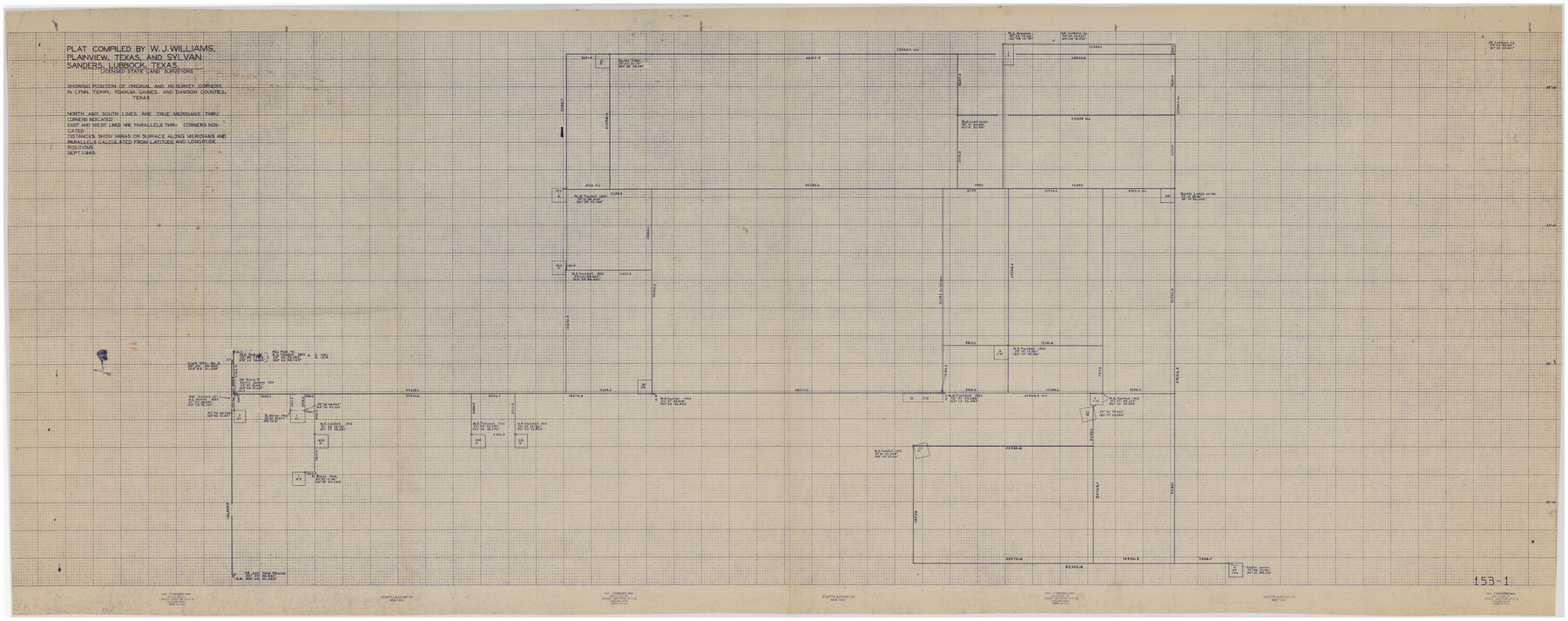
Plat Compiled by W.J. Williams, Plainview, Texas, and Sylvan Sanders, Lubbock, Texas Showing Position of Original and Re-Survey Corners in Lynn, Terry, Yoakum, Gaines, and Dawson Counties, Texas
153-1
Part of: Twichell Survey Records
Castro County, Texas

Print $20.00
- Digital $50.00
Castro County, Texas
Size 20.3 x 22.8 inches
Map/Doc 92613
Eastern Heights Addition - Preliminary Plat Showing Subdivision of SW/4 of SW/4 - Sectin 5 Block O as Proposed by Mr. H. Sieber 38.43 Ac.

Print $20.00
- Digital $50.00
Eastern Heights Addition - Preliminary Plat Showing Subdivision of SW/4 of SW/4 - Sectin 5 Block O as Proposed by Mr. H. Sieber 38.43 Ac.
1952
Size 23.8 x 19.8 inches
Map/Doc 92811
[Sketch of Survey 9, Block Z3]
![93093, [Sketch of Survey 9, Block Z3], Twichell Survey Records](https://historictexasmaps.com/wmedia_w700/maps/93093-1.tif.jpg)
Print $2.00
- Digital $50.00
[Sketch of Survey 9, Block Z3]
Size 7.6 x 6.6 inches
Map/Doc 93093
[Blocks 34-36, Township 1N]
![92031, [Blocks 34-36, Township 1N], Twichell Survey Records](https://historictexasmaps.com/wmedia_w700/maps/92031-1.tif.jpg)
Print $20.00
- Digital $50.00
[Blocks 34-36, Township 1N]
Size 36.8 x 23.8 inches
Map/Doc 92031
[C. C. Slaughter Block 1, T. T. RR. Co. Block 2]
![90622, [C. C. Slaughter Block 1, T. T. RR. Co. Block 2], Twichell Survey Records](https://historictexasmaps.com/wmedia_w700/maps/90622-1.tif.jpg)
Print $3.00
- Digital $50.00
[C. C. Slaughter Block 1, T. T. RR. Co. Block 2]
Size 10.5 x 10.8 inches
Map/Doc 90622
Map of T.C. Spearman's Lands in Gaines, Terry & Yoakum Counties, Texas

Print $20.00
- Digital $50.00
Map of T.C. Spearman's Lands in Gaines, Terry & Yoakum Counties, Texas
1917
Size 44.9 x 37.0 inches
Map/Doc 89779
[Nathaniel H. Cochran Survey and Vicinity]
![91497, [Nathaniel H. Cochran Survey and Vicinity], Twichell Survey Records](https://historictexasmaps.com/wmedia_w700/maps/91497-1.tif.jpg)
Print $20.00
- Digital $50.00
[Nathaniel H. Cochran Survey and Vicinity]
Size 25.5 x 18.8 inches
Map/Doc 91497
Working Sketch of Moore County

Print $20.00
- Digital $50.00
Working Sketch of Moore County
Size 27.7 x 15.6 inches
Map/Doc 93002
Sketch of Southwest Corner of Palo Pinto County

Print $20.00
- Digital $50.00
Sketch of Southwest Corner of Palo Pinto County
Size 13.9 x 12.0 inches
Map/Doc 91647
Ellwood Farms Situated in Hockley, Lamb, and Hale Counties, Texas

Print $20.00
- Digital $50.00
Ellwood Farms Situated in Hockley, Lamb, and Hale Counties, Texas
Size 21.5 x 32.7 inches
Map/Doc 92227
Working Sketch Carson County

Print $3.00
- Digital $50.00
Working Sketch Carson County
1907
Size 11.6 x 17.8 inches
Map/Doc 90224
Howard T. Trigg's Official Map of Amarillo

Print $40.00
- Digital $50.00
Howard T. Trigg's Official Map of Amarillo
Size 79.1 x 54.0 inches
Map/Doc 93196
You may also like
Burlington Route

Print $20.00
- Digital $50.00
Burlington Route
1892
Size 34.9 x 47.7 inches
Map/Doc 93910
Angelina County Sketch File 6

Print $4.00
- Digital $50.00
Angelina County Sketch File 6
1856
Size 8.1 x 8.2 inches
Map/Doc 12933
Harrison County Rolled Sketch 7

Print $20.00
- Digital $50.00
Harrison County Rolled Sketch 7
1953
Size 36.0 x 37.1 inches
Map/Doc 9144
Reeves County Sketch File 9

Print $20.00
- Digital $50.00
Reeves County Sketch File 9
Size 46.3 x 38.2 inches
Map/Doc 10587
Hardeman County Boundary File 38

Print $70.00
- Digital $50.00
Hardeman County Boundary File 38
Size 12.9 x 8.2 inches
Map/Doc 54400
[BIock D13, north part H. & G. N. Block 2]
![90378, [BIock D13, north part H. & G. N. Block 2], Twichell Survey Records](https://historictexasmaps.com/wmedia_w700/maps/90378-1.tif.jpg)
Print $20.00
- Digital $50.00
[BIock D13, north part H. & G. N. Block 2]
Size 14.9 x 20.5 inches
Map/Doc 90378
Hutchinson County Sketch File 16

Print $10.00
- Digital $50.00
Hutchinson County Sketch File 16
1906
Size 11.1 x 8.6 inches
Map/Doc 27213
Brown County Working Sketch 2

Print $20.00
- Digital $50.00
Brown County Working Sketch 2
1919
Size 17.0 x 17.5 inches
Map/Doc 67767
Pecos County Working Sketch 70

Print $20.00
- Digital $50.00
Pecos County Working Sketch 70
1957
Size 31.4 x 27.0 inches
Map/Doc 71542
Young County Working Sketch 10

Print $20.00
- Digital $50.00
Young County Working Sketch 10
1921
Size 24.4 x 34.4 inches
Map/Doc 62033
Gaines County Working Sketch 1

Print $40.00
- Digital $50.00
Gaines County Working Sketch 1
1937
Size 22.7 x 53.1 inches
Map/Doc 69301
