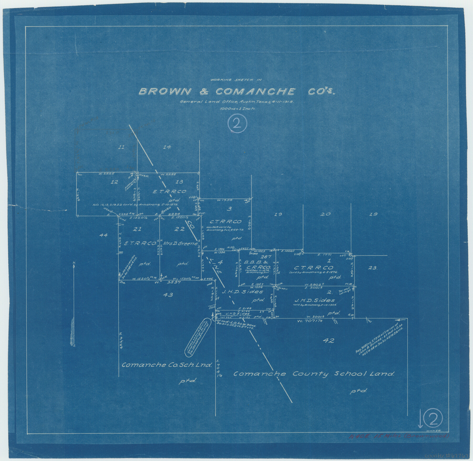
Brown County Working Sketch 2
-
Map/Doc
67767
-
Collection
General Map Collection
-
Object Dates
4/11/1919 (Creation Date)
-
People and Organizations
G.T. Wicker (Draftsman)
-
Counties
Brown Comanche
-
Subjects
Surveying Working Sketch
-
Height x Width
17.0 x 17.5 inches
43.2 x 44.5 cm
-
Scale
1" = 1000 varas
Part of: General Map Collection
Navarro County

Print $40.00
- Digital $50.00
Navarro County
1924
Size 41.1 x 48.2 inches
Map/Doc 77382
Starr County Rolled Sketch 11

Print $20.00
- Digital $50.00
Starr County Rolled Sketch 11
1912
Size 16.5 x 16.4 inches
Map/Doc 7798
Flight Mission No. DQN-1K, Frame 81, Calhoun County

Print $20.00
- Digital $50.00
Flight Mission No. DQN-1K, Frame 81, Calhoun County
1953
Size 18.4 x 22.1 inches
Map/Doc 84166
Map of Smith County

Print $20.00
- Digital $50.00
Map of Smith County
1905
Size 29.8 x 29.7 inches
Map/Doc 4041
Lampasas County Sketch File 12

Print $8.00
- Digital $50.00
Lampasas County Sketch File 12
1874
Size 6.0 x 7.9 inches
Map/Doc 29422
Chart of the West Indies and Spanish Dominions in North America

Print $40.00
- Digital $50.00
Chart of the West Indies and Spanish Dominions in North America
Size 49.1 x 75.6 inches
Map/Doc 97153
Delta County Sketch File 5

Print $2.00
- Digital $50.00
Delta County Sketch File 5
1886
Size 14.6 x 8.6 inches
Map/Doc 20676
Flight Mission No. BRA-7M, Frame 29, Jefferson County

Print $20.00
- Digital $50.00
Flight Mission No. BRA-7M, Frame 29, Jefferson County
1953
Size 18.5 x 22.3 inches
Map/Doc 85480
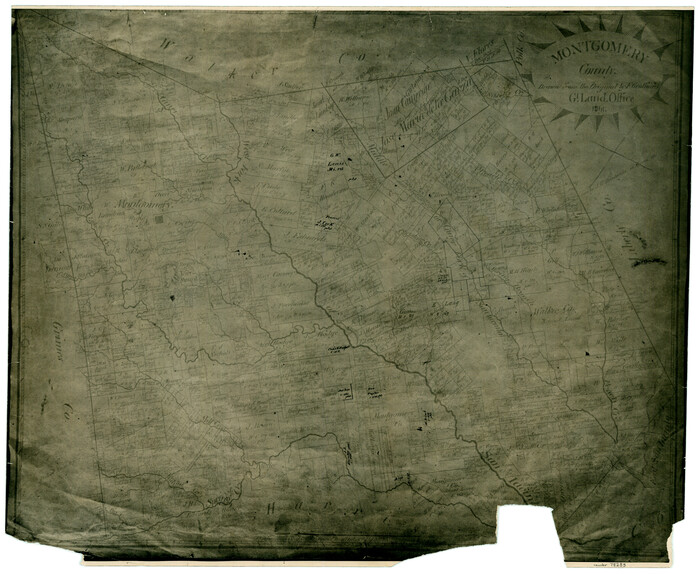
Montgomery County
Print $20.00
- Digital $50.00
Montgomery County
1861
Size 18.5 x 22.6 inches
Map/Doc 78283
Andrews County

Print $40.00
- Digital $50.00
Andrews County
1951
Size 42.7 x 54.5 inches
Map/Doc 1769
Jackson County

Print $40.00
- Digital $50.00
Jackson County
1920
Size 48.5 x 40.8 inches
Map/Doc 4989
Pecos County Rolled Sketch 181

Print $20.00
- Digital $50.00
Pecos County Rolled Sketch 181
1980
Size 18.4 x 18.7 inches
Map/Doc 7300
You may also like
Flight Mission No. DQN-1K, Frame 155, Calhoun County

Print $20.00
- Digital $50.00
Flight Mission No. DQN-1K, Frame 155, Calhoun County
1953
Size 18.5 x 22.2 inches
Map/Doc 84214


Nolan County, Texas

Print $20.00
- Digital $50.00
Nolan County, Texas
1880
Size 29.5 x 22.7 inches
Map/Doc 588
Map of the State of Texas Showing Original Land Districts

Print $20.00
- Digital $50.00
Map of the State of Texas Showing Original Land Districts
1891
Size 42.2 x 42.4 inches
Map/Doc 2138
Matagorda County NRC Article 33.136 Sketch 21

Print $42.00
Matagorda County NRC Article 33.136 Sketch 21
2025
Map/Doc 97429
[Gulf, Colorado & Santa Fe]
![64592, [Gulf, Colorado & Santa Fe], General Map Collection](https://historictexasmaps.com/wmedia_w700/maps/64592.tif.jpg)
Print $40.00
- Digital $50.00
[Gulf, Colorado & Santa Fe]
1918
Size 33.2 x 110.5 inches
Map/Doc 64592
[B. S. & F. Block 1, A. B. & M. Block 2, Block 8 and Block 6]
![91811, [B. S. & F. Block 1, A. B. & M. Block 2, Block 8 and Block 6], Twichell Survey Records](https://historictexasmaps.com/wmedia_w700/maps/91811-1.tif.jpg)
Print $20.00
- Digital $50.00
[B. S. & F. Block 1, A. B. & M. Block 2, Block 8 and Block 6]
1916
Size 26.8 x 32.8 inches
Map/Doc 91811
Hunt County Sketch File 29

Print $4.00
- Digital $50.00
Hunt County Sketch File 29
Size 7.4 x 7.8 inches
Map/Doc 27130
Wharton County

Print $20.00
- Digital $50.00
Wharton County
1946
Size 41.4 x 46.9 inches
Map/Doc 77455
[Liberty County, Texas]
![60297, [Liberty County, Texas], General Map Collection](https://historictexasmaps.com/wmedia_w700/maps/60297-1.tif.jpg)
Print $20.00
- Digital $50.00
[Liberty County, Texas]
1890
Size 24.2 x 16.9 inches
Map/Doc 60297
Jim Nix Farm NW 1/4 Section 40, Block 1 Halsell Subdivision

Print $20.00
- Digital $50.00
Jim Nix Farm NW 1/4 Section 40, Block 1 Halsell Subdivision
Size 12.1 x 13.9 inches
Map/Doc 92400