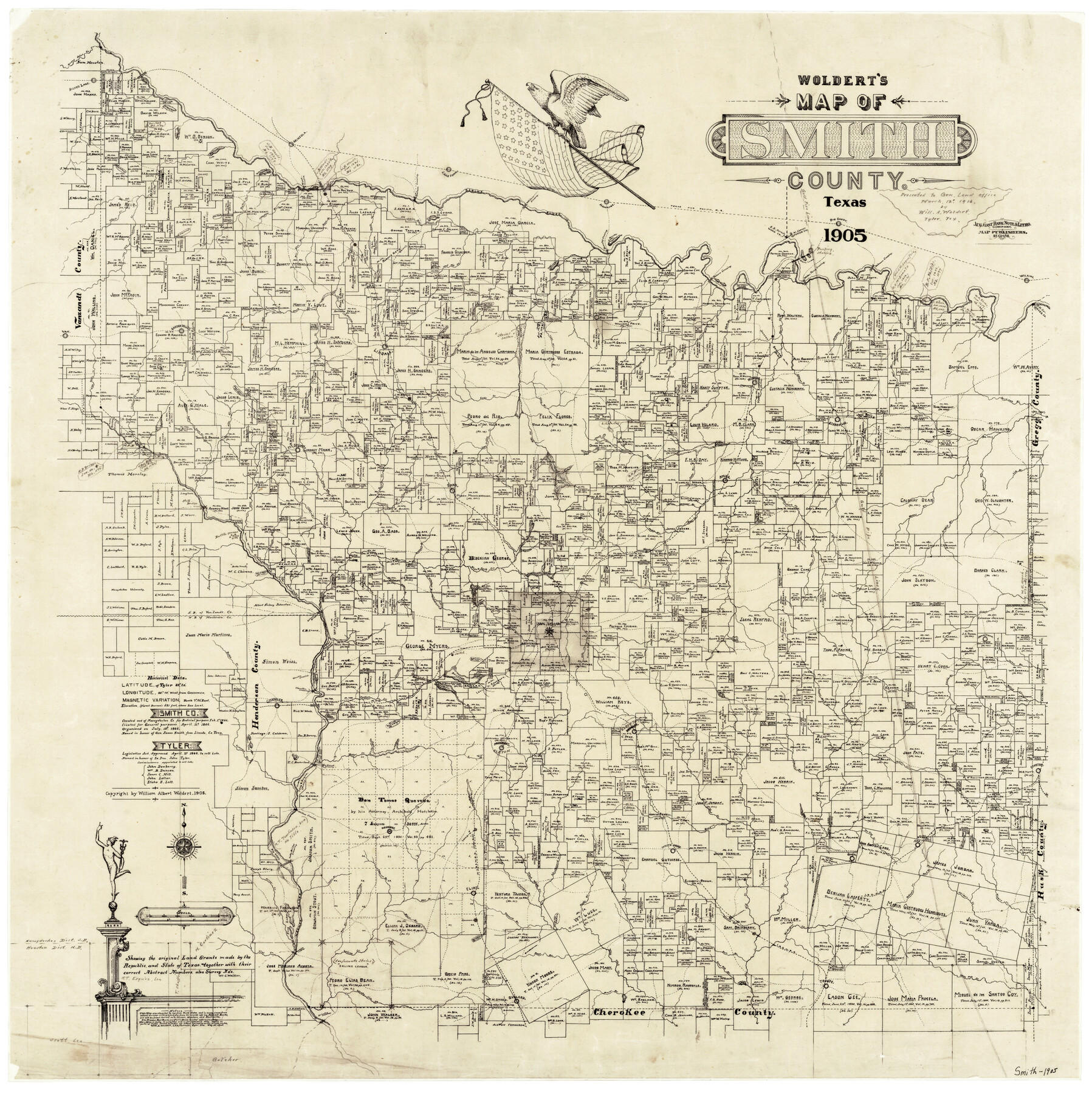
Map of Smith County
-
Map/Doc
4041
-
Collection
General Map Collection
-
Object Dates
1905 (Creation Date)
-
People and Organizations
William Albert Woldert (Publisher)
W.A. Woldert (Surveyor/Engineer)
August Gast Bank Note & Lithograph Company (Lithographer)
-
Counties
Smith
-
Subjects
County
-
Height x Width
29.8 x 29.7 inches
75.7 x 75.4 cm
-
Comments
Copyrighted by William Albert Woldert in 1905.
Presented to General Land Office March 12, 1916 by Will. A. Woldert, Tyler, Texas. -
Features
Grand Sabine Creek
Silver Lake
Mineola
Dry Creek
Burleson Lake
Robertson Lake
Lake Fork
Big Sandy
Hawkins
T&P
Whites Crossing
Sabine River
Quitman Crossing
Old Sabine River Channel
Kings Lake
Mineola Crossing
Beans Branch of Sabine River
Rock Creek
Llewellen Branch [of Indian Creek]
Bois D'arc [sic] Branch [of Sabine River]
Village Creek
South Fork of Village Creek
West Mill Creek
Todd Lake
Little Saline Creek
Brumley Crossing
Brumley Lake
Brumley Creek
Belzora Crossing
Walter's Ferry Crossing
Sabine Lakes
Deleware [sic] Crossing
Wilkins
Deleware [sic] Branch [of Sabine River]
Harris Creek
Glade Branch [of Sabine River]
East Mill Creek
Lynn Branch [of Sabine River]
Red Springs
Tie Creek
Endfield [sic] Branch of Sabine River
Lindale
Duck Creek
Garden Valley
Van
Little Sandy Creek
Hubbard Creek
Cooks Creek
Clay Branch [of Little Saline Creek]
Mt. Carmel
Wiggins Branch [of Sabine River]
Winona
Simpson Creek
Starrville
Mace Branch [of Sabine River]
Gourd Neck Branch of Sabine River
Lick Branch of Sabine River
Goodman Branch [of Mann's Creek]
Brigham Branch of Sabine River
Amigo
Muse Creek
Hitt's Creek
Hopewell
Swan
White Wash Branch [of Prairie Creek]
Mt. Sylvan
Allen Branch of Neches River
Lindsey Branch [of Neches River]
Rattle Snake Branch [of Neches River]
McDougal Branch of Sabine River
Center Branch [of Harris Creek]
Thunderstruck Creek
Spear Branch [of Simpson Creek]
Mann's Creek
Bass
Graybill Branch [of Mann's Creek]
Ogburn Branch [of Thunderstruck Creek]
Rays Creek
Holly
Black Fork Creek
Steadham Branch of Neches River
Chinquepin Branch [of Prairie Creek]
Clear Branch [of Prairie Creek]
Gimble Branch [of Neches River]
Davis Branch [of Neches River]
Wimberly Branch of Neches River
Neches River
Adams Branch [of Prairie Creek]
McFarland Branch [of Prairie Creek]
Owens
Jones Creek
Wilders Creek
Jamestown
Fartson Branch of Sabine River
Hudnall Creek
Kelly Creek
Tyler
Chancellor Branch [of Indian Creek]
L'Lewellan Branch of Neches River
Switch
Indian Creek
Venable Crossing
Chandler Crossing
Chandler
Battle Creek
Twin Lakes
Kickapoo Creek
Russian Lake
Butler Creek
Green Briar Lake
Elkton
Elberta
Tunnell Branch [of East Mud Creek]
Curtis Branch [of Rabbitt Creek]
Rabbitt Creek
Yarbrough Crossing
Britler Creek
Hill Creek
Lowery Branch of East Mud Creek
Mason Creek
Overton
Goss Williams Branch [of Sabine River]
Honey Pond
Arp
Pen Vine Creek
Omen
Hays Creek
Guapaw [sic] Creek
White House
Lamdin
Noonday
Wallace Crossing
Big Eddy [of Neches River]
SLS
Willshire Creek
Strikers Creek
Gant Branch of Robinson Creek
Robinson Creek
I&GN
East Mud Creek
Grassy Lake
Willingham
Gurnett Branch of East Mud Creek
Brier Branch [of West Mud Creek]
Roddy Branch [of West Mud Creek]
Shackelford Creek
Herishaw Branch of West Mud Creek
Flint
Goodson
Blow Branch [of Saline Creek]
Biscoe Branch [of Saline Creek]
Copperas Branch [of Saline Creek]
Collins Branch of Neches River
Brewer Creek
Flat Creek
Flag Lakes
Norwigian [sic] Crossing
Rose Branch [of Saline Creek]
Saline Creek
Old Mt. Vernon
Deans Branch of West Mud Creek
Bell Branch [of East Mud Creek]
Grand Pap Branch of East Mud Creek
Jolly Lake
Well Branch [of East Mud Creek]
Troupe
Horse Pen Creek
Bullard
Aretha
County Line Creek
Brindley Crossing
Lake Charter
Flora
Mary's Creek
Redfield Creek
Chapman Branch [of Tie Creek]
Stuart Branch [of Hubbard Creek]
Flora
Rocky Branch [of Little Saline Creek]
Todd Branch [of Little Saline Cree]
Carrol Branch [of East Mill Creek]
Bonds Branch [of East Mill Creek]
Prairie Creek
Caney Creek
Lollard's Bridge
Price Branch [of Neches River]
Venable Lake
Bellwood [Lake]
Greenbrier
Ramsour Creek
Lake Bridge Crossing
Coffins Branch [of Neches River]
Cowsar Branch [of West Mud Creek]
West Mud Creek
Garnett Branch [of East Mud Creek]
Grant Branch [of Robinson Creek]
Beaver Branch [of West Mud Creek]
Old Mount Vernon
Oretha
Part of: General Map Collection
Flight Mission No. DIX-6P, Frame 126, Aransas County

Print $20.00
- Digital $50.00
Flight Mission No. DIX-6P, Frame 126, Aransas County
1956
Size 19.3 x 22.9 inches
Map/Doc 83832
Flight Mission No. BRE-1P, Frame 73, Nueces County

Print $20.00
- Digital $50.00
Flight Mission No. BRE-1P, Frame 73, Nueces County
1956
Size 18.5 x 22.4 inches
Map/Doc 86655
Edwards County Working Sketch 39

Print $20.00
- Digital $50.00
Edwards County Working Sketch 39
1948
Size 28.7 x 32.3 inches
Map/Doc 68915
Map of Van Zandt County

Print $20.00
- Digital $50.00
Map of Van Zandt County
1853
Size 19.4 x 20.6 inches
Map/Doc 16957
Crockett County Sketch File KL

Print $20.00
- Digital $50.00
Crockett County Sketch File KL
1925
Size 30.0 x 28.7 inches
Map/Doc 11243

Flight Mission No. BRA-7M, Frame 144, Jefferson County

Print $20.00
- Digital $50.00
Flight Mission No. BRA-7M, Frame 144, Jefferson County
1953
Size 18.5 x 22.3 inches
Map/Doc 85538
Flight Mission No. CRE-1R, Frame 130, Jackson County

Print $20.00
- Digital $50.00
Flight Mission No. CRE-1R, Frame 130, Jackson County
1956
Size 18.4 x 22.3 inches
Map/Doc 85338
Bosque County Working Sketch 1

Print $20.00
- Digital $50.00
Bosque County Working Sketch 1
Size 16.3 x 13.7 inches
Map/Doc 67434
Wise County Sketch File 34

Print $6.00
- Digital $50.00
Wise County Sketch File 34
1856
Size 6.3 x 9.6 inches
Map/Doc 40592
Ellis County Sketch File 13

Print $40.00
- Digital $50.00
Ellis County Sketch File 13
1860
Size 12.6 x 16.0 inches
Map/Doc 21852
Brazos River, Brazos River Sheet 8

Print $20.00
- Digital $50.00
Brazos River, Brazos River Sheet 8
1926
Size 22.2 x 27.7 inches
Map/Doc 69672
You may also like
Young County Sketch File 10a

Print $4.00
- Digital $50.00
Young County Sketch File 10a
1879
Size 8.0 x 7.5 inches
Map/Doc 40868
Flight Mission No. BRA-7M, Frame 82, Jefferson County

Print $20.00
- Digital $50.00
Flight Mission No. BRA-7M, Frame 82, Jefferson County
1953
Size 16.1 x 15.9 inches
Map/Doc 85504
[North line of County]
![93142, [North line of County], Twichell Survey Records](https://historictexasmaps.com/wmedia_w700/maps/93142-1.tif.jpg)
Print $40.00
- Digital $50.00
[North line of County]
Size 120.1 x 7.0 inches
Map/Doc 93142
Flight Mission No. DQO-7K, Frame 98, Galveston County

Print $20.00
- Digital $50.00
Flight Mission No. DQO-7K, Frame 98, Galveston County
1952
Size 18.8 x 22.4 inches
Map/Doc 85113
Map of section no. 5 of a survey of Padre Island made for the Office of the Attorney General of the State of Texas

Print $40.00
- Digital $50.00
Map of section no. 5 of a survey of Padre Island made for the Office of the Attorney General of the State of Texas
1941
Size 49.8 x 40.0 inches
Map/Doc 2261

Wichita County Working Sketch 12b

Print $20.00
- Digital $50.00
Wichita County Working Sketch 12b
1920
Size 21.2 x 14.9 inches
Map/Doc 72522
Concho County Sketch File 33a

Print $22.00
- Digital $50.00
Concho County Sketch File 33a
Size 21.4 x 19.4 inches
Map/Doc 11159
General Highway Map, Brooks County, Texas

Print $20.00
General Highway Map, Brooks County, Texas
1940
Size 18.5 x 25.0 inches
Map/Doc 79030
Map of Lampasas County

Print $20.00
- Digital $50.00
Map of Lampasas County
1856
Size 19.7 x 25.3 inches
Map/Doc 3792
Briscoe County Sketch File P

Print $40.00
- Digital $50.00
Briscoe County Sketch File P
Size 23.1 x 34.0 inches
Map/Doc 11014
Map of Texas and the countries adjacent compiled in the Bureau of the Corps of Topographical Engineers from the best authorities for the State Department

Print $20.00
- Digital $50.00
Map of Texas and the countries adjacent compiled in the Bureau of the Corps of Topographical Engineers from the best authorities for the State Department
1844
Size 26.1 x 18.2 inches
Map/Doc 72715