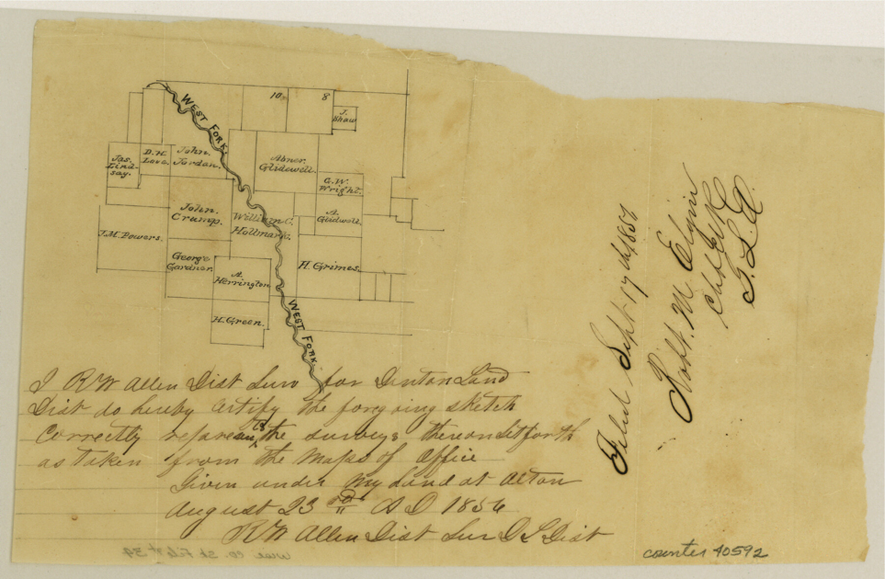
Wise County Sketch File 34
[Sketches of areas in the southeast corner of county]
-
Map/Doc
40592
-
Collection
General Map Collection
-
Object Dates
1856 & 1875 (Creation Date)
-
People and Organizations
H.M. Berry (Surveyor/Engineer)
R.W. Allen (Surveyor/Engineer)
-
Counties
Wise Tarrant
-
Subjects
Surveying Sketch File
-
Height x Width
6.3 x 9.6 inches
16.0 x 24.4 cm
-
Medium
paper, manuscript
-
Features
West Fork [of Trinity River]
Part of: General Map Collection
Flight Mission No. DQN-6K, Frame 15, Calhoun County

Print $20.00
- Digital $50.00
Flight Mission No. DQN-6K, Frame 15, Calhoun County
1953
Size 18.4 x 22.2 inches
Map/Doc 84437
El Paso County Working Sketch 9

Print $20.00
- Digital $50.00
El Paso County Working Sketch 9
1955
Size 28.0 x 25.0 inches
Map/Doc 69031
Oil Fields of the Texas-Louisiana Gulf Coastal Plain

Oil Fields of the Texas-Louisiana Gulf Coastal Plain
1903
Map/Doc 97518
Mitchell County Sketch File 13

Print $20.00
- Digital $50.00
Mitchell County Sketch File 13
1925
Size 19.3 x 16.3 inches
Map/Doc 12100

Jackson County Sketch File 3

Print $34.00
- Digital $50.00
Jackson County Sketch File 3
1875
Size 7.9 x 7.7 inches
Map/Doc 27621
Caldwell County Sketch File 4a

Print $8.00
- Digital $50.00
Caldwell County Sketch File 4a
1898
Size 11.2 x 8.8 inches
Map/Doc 35835
Kenedy County Rolled Sketch 15

Print $15.00
- Digital $50.00
Kenedy County Rolled Sketch 15
1942
Size 10.2 x 15.2 inches
Map/Doc 46426
[Liberty County, Texas]
![2058, [Liberty County, Texas], General Map Collection](https://historictexasmaps.com/wmedia_w700/maps/2058-1.tif.jpg)
Print $20.00
- Digital $50.00
[Liberty County, Texas]
1890
Size 23.7 x 18.3 inches
Map/Doc 2058
Wheeler County

Print $20.00
- Digital $50.00
Wheeler County
1899
Size 42.2 x 37.9 inches
Map/Doc 95672
Reagan County Working Sketch 26

Print $20.00
- Digital $50.00
Reagan County Working Sketch 26
1960
Size 29.4 x 41.0 inches
Map/Doc 71868
San Jacinto County Working Sketch 2

Print $20.00
- Digital $50.00
San Jacinto County Working Sketch 2
1917
Size 18.7 x 15.9 inches
Map/Doc 63715
You may also like
Panola County Working Sketch 41

Print $20.00
- Digital $50.00
Panola County Working Sketch 41
1995
Map/Doc 71450
Fisher County Working Sketch 20

Print $20.00
- Digital $50.00
Fisher County Working Sketch 20
1993
Size 38.1 x 26.6 inches
Map/Doc 69154
Kimble County Sketch File 28

Print $20.00
- Digital $50.00
Kimble County Sketch File 28
Size 23.3 x 17.8 inches
Map/Doc 11927
Freestone County Rolled Sketch 13A

Print $20.00
- Digital $50.00
Freestone County Rolled Sketch 13A
1990
Size 45.2 x 33.7 inches
Map/Doc 5914
Wilbarger County Working Sketch 15

Print $20.00
- Digital $50.00
Wilbarger County Working Sketch 15
1955
Size 32.5 x 25.5 inches
Map/Doc 72553
Rusk County Sketch File 9

Print $4.00
Rusk County Sketch File 9
1849
Size 8.4 x 8.2 inches
Map/Doc 35505
Ector County Working Sketch 25

Print $20.00
- Digital $50.00
Ector County Working Sketch 25
1961
Size 29.6 x 34.2 inches
Map/Doc 68868
Burnet County Sketch File 30

Print $4.00
- Digital $50.00
Burnet County Sketch File 30
Size 11.0 x 8.0 inches
Map/Doc 16746
Oil Fields of the Texas-Louisiana Gulf Coastal Plain
Oil Fields of the Texas-Louisiana Gulf Coastal Plain
1903
Map/Doc 97518
Map of McLennan Co[unty]
![88974, Map of McLennan Co[unty], Library of Congress](https://historictexasmaps.com/wmedia_w700/maps/88974.tif.jpg)
Print $40.00
Map of McLennan Co[unty]
1896
Size 47.9 x 53.6 inches
Map/Doc 88974
Map of Comanche County

Print $20.00
- Digital $50.00
Map of Comanche County
1884
Size 20.9 x 26.5 inches
Map/Doc 3434
Nelson & White's Official Map of Beaumont

Print $40.00
Nelson & White's Official Map of Beaumont
1902
Size 54.3 x 39.4 inches
Map/Doc 93558