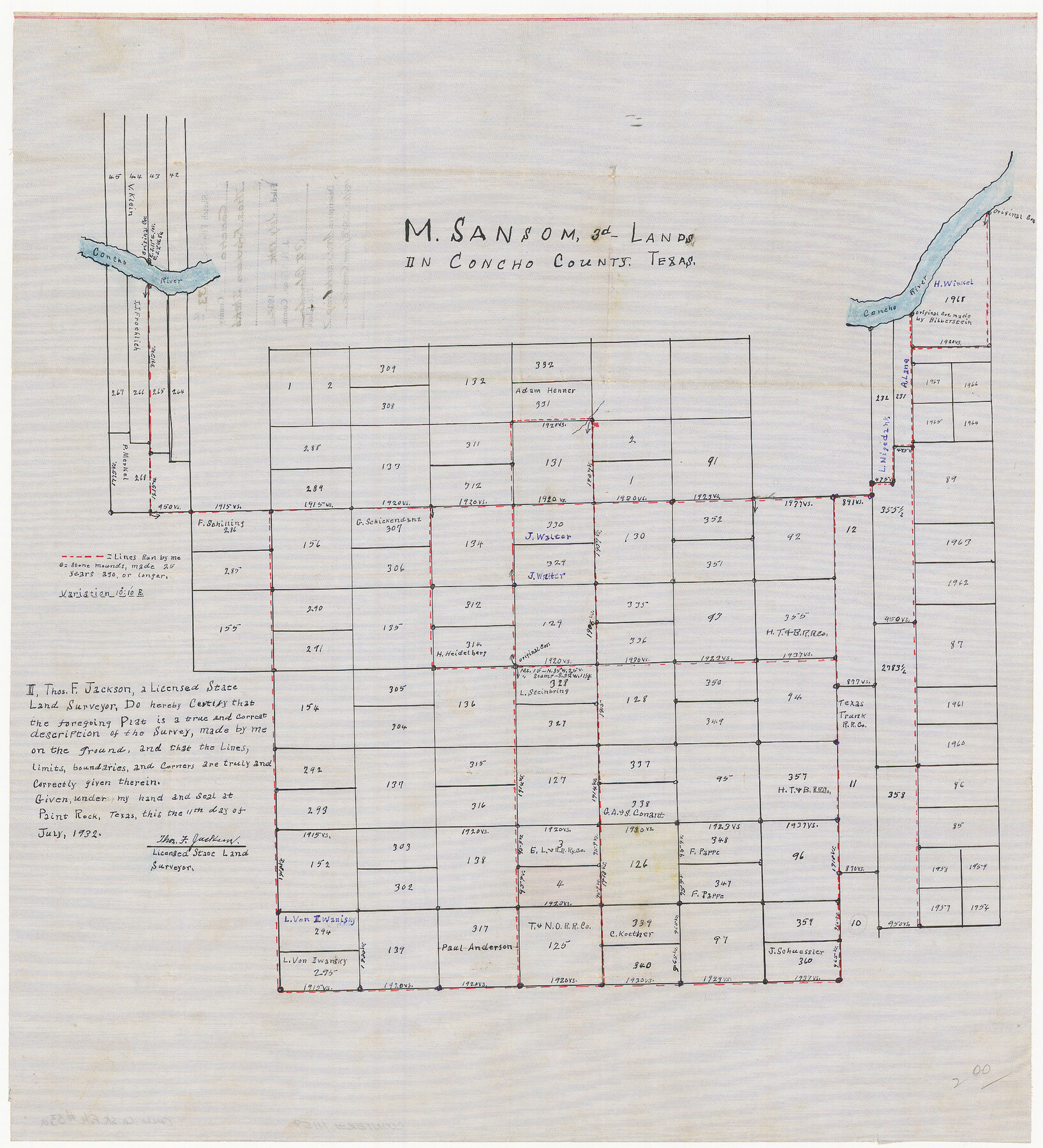
Concho County Sketch File 33a
[Letter regarding surveys southeast of Concho]
-
Map/Doc
11159
-
Collection
General Map Collection
-
Object Dates
7/13/1932 (File Date)
-
People and Organizations
Thomas F. Jackson (Surveyor/Engineer)
-
Counties
Concho
-
Subjects
Surveying Sketch File
-
Height x Width
21.4 x 19.4 inches
54.4 x 49.3 cm
-
Medium
paper, manuscript
-
Features
Concho River
Part of: General Map Collection
Titus County Sketch File 7

Print $4.00
- Digital $50.00
Titus County Sketch File 7
1853
Size 10.0 x 8.2 inches
Map/Doc 38142
Hunt County Working Sketch 4

Print $20.00
- Digital $50.00
Hunt County Working Sketch 4
1923
Size 21.3 x 30.5 inches
Map/Doc 66351
Flight Mission No. CRE-3R, Frame 37, Jackson County

Print $20.00
- Digital $50.00
Flight Mission No. CRE-3R, Frame 37, Jackson County
1956
Size 18.5 x 22.3 inches
Map/Doc 85383
Reeves County Sketch File 27

Print $14.00
- Digital $50.00
Reeves County Sketch File 27
1982
Size 11.5 x 8.9 inches
Map/Doc 35228
Sutton County Working Sketch 3

Print $20.00
- Digital $50.00
Sutton County Working Sketch 3
1968
Size 23.6 x 34.5 inches
Map/Doc 62346
Liberty County Working Sketch 46

Print $20.00
- Digital $50.00
Liberty County Working Sketch 46
1953
Size 18.6 x 37.6 inches
Map/Doc 70505
Floyd County Sketch File A1

Print $4.00
- Digital $50.00
Floyd County Sketch File A1
Size 9.2 x 7.9 inches
Map/Doc 22686
Harris County Historic Topographic 23

Print $20.00
- Digital $50.00
Harris County Historic Topographic 23
1916
Size 29.2 x 22.6 inches
Map/Doc 65834
Upton County Rolled Sketch 18

Print $40.00
- Digital $50.00
Upton County Rolled Sketch 18
1933
Size 38.3 x 55.5 inches
Map/Doc 10039
Lighthouse establishment on the Atlantic and Gulf Coasts and coast signal stations

Print $20.00
- Digital $50.00
Lighthouse establishment on the Atlantic and Gulf Coasts and coast signal stations
1898
Size 25.1 x 18.3 inches
Map/Doc 73051

Controlled Mosaic by Jack Amman Photogrammetric Engineers, Inc - Sheet 16

Print $20.00
- Digital $50.00
Controlled Mosaic by Jack Amman Photogrammetric Engineers, Inc - Sheet 16
1954
Size 20.0 x 24.0 inches
Map/Doc 83460
You may also like
Coke County Sketch File 29

Print $20.00
- Digital $50.00
Coke County Sketch File 29
Size 10.9 x 21.8 inches
Map/Doc 11114
Reagan County Rolled Sketch 17

Print $20.00
- Digital $50.00
Reagan County Rolled Sketch 17
Size 33.9 x 32.6 inches
Map/Doc 10623
Lamar County Boundary File 56a

Print $34.00
- Digital $50.00
Lamar County Boundary File 56a
Size 8.7 x 14.3 inches
Map/Doc 56020
Shelby County

Print $40.00
- Digital $50.00
Shelby County
1897
Size 43.4 x 50.1 inches
Map/Doc 63033
Real County Working Sketch 84

Print $20.00
- Digital $50.00
Real County Working Sketch 84
1986
Size 25.0 x 40.7 inches
Map/Doc 71976
Hutchinson County Rolled Sketch 43

Print $40.00
- Digital $50.00
Hutchinson County Rolled Sketch 43
1992
Size 40.5 x 49.4 inches
Map/Doc 6316
Nueces County Rolled Sketch 12

Print $40.00
- Digital $50.00
Nueces County Rolled Sketch 12
Size 40.3 x 54.1 inches
Map/Doc 9587
Presidio County Sketch File 49

Print $6.00
- Digital $50.00
Presidio County Sketch File 49
1919
Size 14.6 x 11.9 inches
Map/Doc 34584
Orange County Working Sketch 50

Print $20.00
- Digital $50.00
Orange County Working Sketch 50
1991
Size 36.0 x 43.6 inches
Map/Doc 71382
Ector County Rolled Sketch 7

Print $20.00
- Digital $50.00
Ector County Rolled Sketch 7
1936
Size 37.1 x 30.4 inches
Map/Doc 5778
Culberson County Working Sketch 75

Print $40.00
- Digital $50.00
Culberson County Working Sketch 75
1975
Size 48.1 x 32.8 inches
Map/Doc 68529
