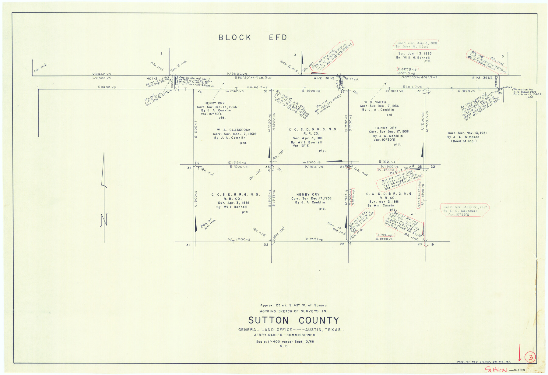
Sutton County Working Sketch 3
-
Map/Doc
62346
-
Collection
General Map Collection
-
Object Dates
9/10/1968 (Creation Date)
-
People and Organizations
Roy Buckholts (Draftsman)
-
Counties
Sutton
-
Subjects
Surveying Working Sketch
-
Height x Width
23.6 x 34.5 inches
59.9 x 87.6 cm
-
Scale
1" = 400 varas
Part of: General Map Collection
Runnels County Rolled Sketch 52

Print $20.00
- Digital $50.00
Runnels County Rolled Sketch 52
Size 26.4 x 36.3 inches
Map/Doc 7537
Atascosa County Sketch File 27c

Print $12.00
- Digital $50.00
Atascosa County Sketch File 27c
1876
Size 12.7 x 8.4 inches
Map/Doc 13806
Flight Mission No. CLL-1N, Frame 157, Willacy County

Print $20.00
- Digital $50.00
Flight Mission No. CLL-1N, Frame 157, Willacy County
1954
Size 18.3 x 22.0 inches
Map/Doc 87048
2016 Official Travel Map, Texas

2016 Official Travel Map, Texas
Size 33.3 x 36.2 inches
Map/Doc 94298
Angelina County

Print $40.00
- Digital $50.00
Angelina County
1945
Size 38.7 x 49.3 inches
Map/Doc 1770
Hardin County Sketch File 55

Print $40.00
- Digital $50.00
Hardin County Sketch File 55
1924
Size 14.2 x 13.3 inches
Map/Doc 25220
[Sketch for Mineral Application 24072, San Jacinto River]
![65598, [Sketch for Mineral Application 24072, San Jacinto River], General Map Collection](https://historictexasmaps.com/wmedia_w700/maps/65598.tif.jpg)
Print $20.00
- Digital $50.00
[Sketch for Mineral Application 24072, San Jacinto River]
1929
Size 24.6 x 18.3 inches
Map/Doc 65598

Burnet County Sketch File 13

Print $4.00
- Digital $50.00
Burnet County Sketch File 13
1848
Size 12.8 x 8.2 inches
Map/Doc 16696
Terrell County Working Sketch 63

Print $20.00
- Digital $50.00
Terrell County Working Sketch 63
1970
Size 37.8 x 35.9 inches
Map/Doc 69584
Corpus Christi Harbor

Print $40.00
- Digital $50.00
Corpus Christi Harbor
1976
Size 37.1 x 51.5 inches
Map/Doc 73480
Cameron County Rolled Sketch 7

Print $20.00
- Digital $50.00
Cameron County Rolled Sketch 7
1926
Size 27.4 x 31.8 inches
Map/Doc 8563
You may also like
Brazos County Working Sketch 9

Print $20.00
- Digital $50.00
Brazos County Working Sketch 9
1982
Size 36.2 x 48.8 inches
Map/Doc 67484
Liberty County Sketch File 58

Print $2.00
- Digital $50.00
Liberty County Sketch File 58
Size 8.9 x 7.7 inches
Map/Doc 30060
Flight Mission No. DQO-7K, Frame 75, Galveston County

Print $20.00
- Digital $50.00
Flight Mission No. DQO-7K, Frame 75, Galveston County
1952
Size 18.9 x 22.4 inches
Map/Doc 85102
Laguna Madre, Register No. 1477A

Print $40.00
- Digital $50.00
Laguna Madre, Register No. 1477A
1880
Size 34.3 x 56.0 inches
Map/Doc 73606
Runnels County Rolled Sketch 34

Print $20.00
- Digital $50.00
Runnels County Rolled Sketch 34
Size 30.1 x 35.1 inches
Map/Doc 7522
Flight Mission No. BRA-16M, Frame 150, Jefferson County

Print $20.00
- Digital $50.00
Flight Mission No. BRA-16M, Frame 150, Jefferson County
1953
Size 18.5 x 22.3 inches
Map/Doc 85756
The Judicial District/Counties, Late Spring 1842

Print $20.00
The Judicial District/Counties, Late Spring 1842
2020
Size 24.5 x 21.7 inches
Map/Doc 96356
[Part of Block A4, Block C2]
![90744, [Part of Block A4, Block C2], Twichell Survey Records](https://historictexasmaps.com/wmedia_w700/maps/90744-1.tif.jpg)
Print $20.00
- Digital $50.00
[Part of Block A4, Block C2]
Size 14.7 x 20.4 inches
Map/Doc 90744
Hutchinson County Sketch File 19

Print $16.00
- Digital $50.00
Hutchinson County Sketch File 19
1913
Size 8.0 x 5.2 inches
Map/Doc 27234
Jefferson County NRC Article 33.136 Sketch 15

Print $38.00
Jefferson County NRC Article 33.136 Sketch 15
2020
Map/Doc 97253
Eastland County Sketch File 7

Print $4.00
- Digital $50.00
Eastland County Sketch File 7
1872
Size 12.6 x 8.5 inches
Map/Doc 21574
Borden County Sketch File 3

Print $4.00
- Digital $50.00
Borden County Sketch File 3
1902
Size 7.3 x 12.8 inches
Map/Doc 14703