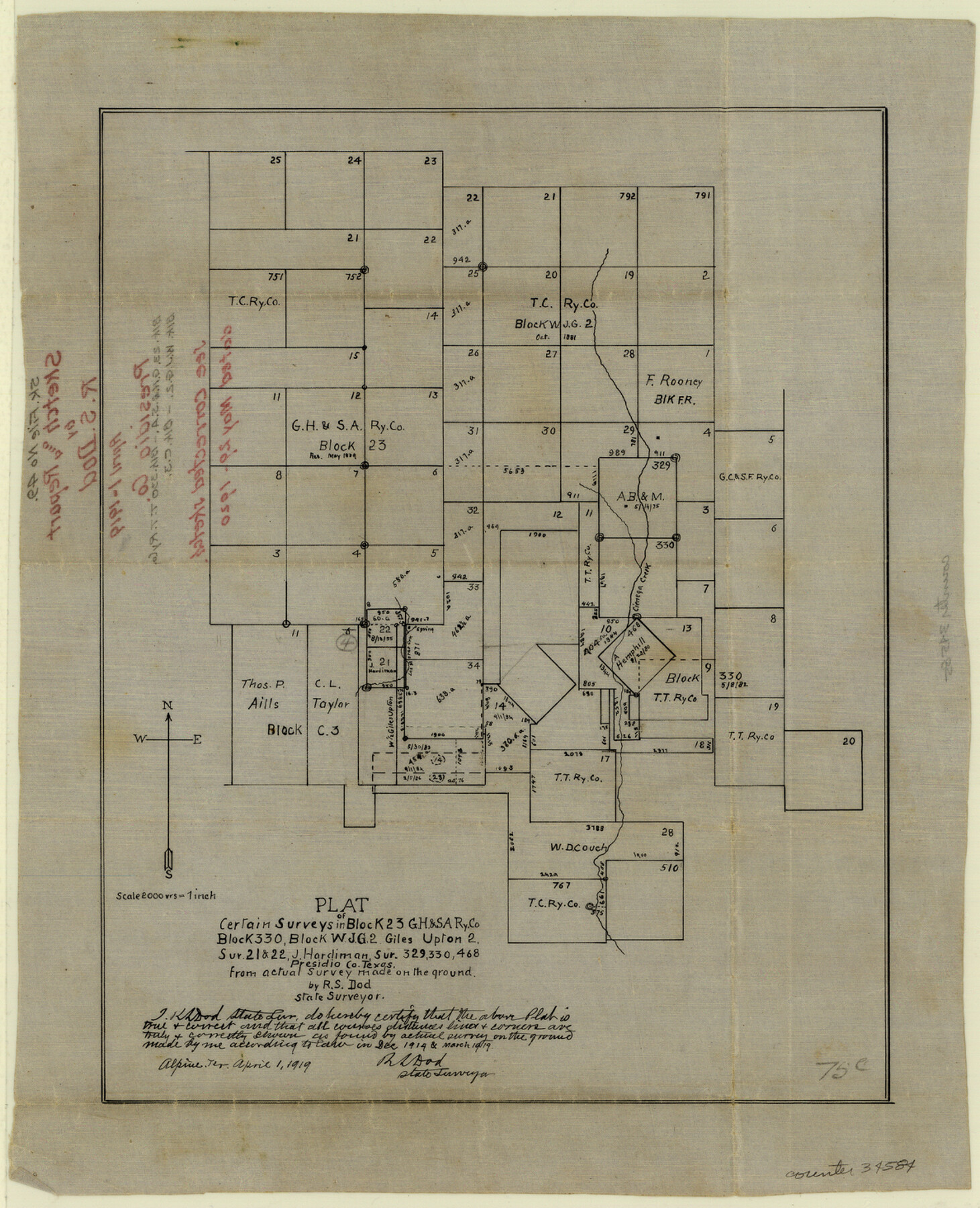
Presidio County Sketch File 49
Plat of certain surveys in Block 23, G. H. & S. A. RR. Co. Block 330, Block WJG2, Giles Upton 2, surveys 21 and 22, J. Hardiman survey 329, 330, 468, from actual survey made on the ground by R. S. Dod
-
Map/Doc
34584
-
Collection
General Map Collection
-
Object Dates
4/1/1919 (Creation Date)
12/1914 (Survey Date)
3/1919 (Survey Date)
-
People and Organizations
R.S. Dod (Surveyor/Engineer)
-
Counties
Presidio
-
Subjects
Surveying Sketch File
-
Height x Width
14.6 x 11.9 inches
37.1 x 30.2 cm
-
Medium
paper, manuscript
-
Scale
1" = 2000 varas
-
Features
Cienega Creek
Part of: General Map Collection
[Plat and field notes of 3.107 acre tract for Clement Cove Harbor Company]
![60397, [Plat and field notes of 3.107 acre tract for Clement Cove Harbor Company], General Map Collection](https://historictexasmaps.com/wmedia_w700/maps/60397-1.tif.jpg)
Print $20.00
- Digital $50.00
[Plat and field notes of 3.107 acre tract for Clement Cove Harbor Company]
1987
Size 24.2 x 36.5 inches
Map/Doc 60397
Val Verde County Sketch File XX

Print $20.00
- Digital $50.00
Val Verde County Sketch File XX
Size 14.5 x 16.7 inches
Map/Doc 12546
Bell County Sketch File 23a

Print $6.00
- Digital $50.00
Bell County Sketch File 23a
1873
Size 10.0 x 15.7 inches
Map/Doc 14416
Panola County Sketch File 9

Print $8.00
- Digital $50.00
Panola County Sketch File 9
Size 13.9 x 8.5 inches
Map/Doc 33461

Lampasas County Sketch File 20

Print $4.00
- Digital $50.00
Lampasas County Sketch File 20
Size 7.4 x 8.7 inches
Map/Doc 29434
Bowie County Sketch File A

Print $40.00
- Digital $50.00
Bowie County Sketch File A
1902
Size 15.6 x 27.3 inches
Map/Doc 10946
Flight Mission No. CGI-3N, Frame 98, Cameron County

Print $20.00
- Digital $50.00
Flight Mission No. CGI-3N, Frame 98, Cameron County
1954
Size 18.5 x 22.1 inches
Map/Doc 84578
Jackson County Working Sketch 5

Print $20.00
- Digital $50.00
Jackson County Working Sketch 5
1953
Size 26.2 x 26.0 inches
Map/Doc 66453
Flight Mission No. BRA-17M, Frame 2, Jefferson County

Print $20.00
- Digital $50.00
Flight Mission No. BRA-17M, Frame 2, Jefferson County
1953
Size 18.6 x 22.3 inches
Map/Doc 85782
Map of West Part of Pecos Co.

Print $20.00
- Digital $50.00
Map of West Part of Pecos Co.
1896
Size 47.4 x 39.3 inches
Map/Doc 66974
Shelby County Sketch File 13

Print $2.00
- Digital $50.00
Shelby County Sketch File 13
1859
Size 8.2 x 12.8 inches
Map/Doc 36621
You may also like
Shelby County Rolled Sketch 6

Print $20.00
- Digital $50.00
Shelby County Rolled Sketch 6
Size 26.7 x 20.9 inches
Map/Doc 7776
Val Verde County Working Sketch 94

Print $20.00
- Digital $50.00
Val Verde County Working Sketch 94
1979
Size 31.6 x 42.3 inches
Map/Doc 72229
Houston County

Print $40.00
- Digital $50.00
Houston County
1944
Size 50.3 x 50.3 inches
Map/Doc 73184
Flight Mission No. BRE-2P, Frame 83, Nueces County

Print $20.00
- Digital $50.00
Flight Mission No. BRE-2P, Frame 83, Nueces County
1956
Size 18.5 x 22.4 inches
Map/Doc 86778
Pecos County Sketch File 78

Print $6.00
- Digital $50.00
Pecos County Sketch File 78
1943
Size 11.1 x 8.8 inches
Map/Doc 33911
Flight Mission No. DAG-21K, Frame 127, Matagorda County

Print $20.00
- Digital $50.00
Flight Mission No. DAG-21K, Frame 127, Matagorda County
1952
Size 18.5 x 22.4 inches
Map/Doc 86453
Map of Mason County

Print $20.00
- Digital $50.00
Map of Mason County
1877
Size 25.3 x 19.9 inches
Map/Doc 3836
Gregg County Working Sketch 7

Print $20.00
- Digital $50.00
Gregg County Working Sketch 7
1934
Size 32.2 x 21.0 inches
Map/Doc 63273
Hale County Rolled Sketch 8

Print $20.00
- Digital $50.00
Hale County Rolled Sketch 8
1910
Size 38.0 x 25.9 inches
Map/Doc 6046
Duval County Sketch File 20

Print $20.00
- Digital $50.00
Duval County Sketch File 20
1880
Size 17.9 x 14.6 inches
Map/Doc 11384

Harris County Rolled Sketch 94

Print $20.00
- Digital $50.00
Harris County Rolled Sketch 94
1985
Size 33.8 x 18.4 inches
Map/Doc 6133