Titus County Sketch File 7
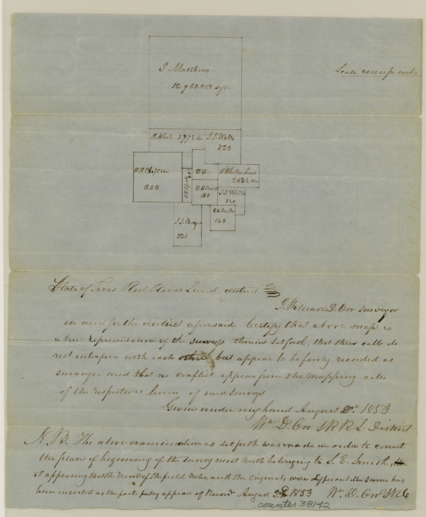
[Sketch and explanation of surveys west from Mount Pleasant near the county line]
-
Map/Doc
38142
-
Collection
General Map Collection
-
Object Dates
8/2/1853 (Creation Date)
9/22/1853 (File Date)
-
People and Organizations
William D. Orr (Surveyor/Engineer)
-
Counties
Titus
-
Subjects
Surveying Sketch File
-
Height x Width
10.0 x 8.2 inches
25.4 x 20.8 cm
-
Medium
paper, manuscript
-
Scale
1" = 2000 varas
Part of: General Map Collection
Galveston County Rolled Sketch 42

Print $20.00
- Digital $50.00
Galveston County Rolled Sketch 42
1982
Size 42.9 x 40.6 inches
Map/Doc 9021
Brazoria County Sketch File 1a

Print $6.00
- Digital $50.00
Brazoria County Sketch File 1a
1861
Size 12.5 x 11.5 inches
Map/Doc 14918
Runnels County Rolled Sketch 40

Print $20.00
- Digital $50.00
Runnels County Rolled Sketch 40
Size 32.3 x 38.9 inches
Map/Doc 7528
Edwards County Sketch File 31

Print $6.00
- Digital $50.00
Edwards County Sketch File 31
1926
Size 14.5 x 8.8 inches
Map/Doc 21762
DeWitt County Working Sketch Graphic Index

Print $20.00
- Digital $50.00
DeWitt County Working Sketch Graphic Index
1920
Size 39.7 x 46.7 inches
Map/Doc 76522
Flight Mission No. CRC-2R, Frame 112, Chambers County

Print $20.00
- Digital $50.00
Flight Mission No. CRC-2R, Frame 112, Chambers County
1956
Size 18.5 x 22.3 inches
Map/Doc 84739
Nueces County Sketch File 71

Print $19.00
- Digital $50.00
Nueces County Sketch File 71
1991
Size 11.2 x 8.7 inches
Map/Doc 33011
Kaufman County Boundary File 6

Print $14.00
- Digital $50.00
Kaufman County Boundary File 6
Size 11.2 x 8.7 inches
Map/Doc 55956
Carta Geografica Della Florida Nell America Settentrionale

Print $20.00
- Digital $50.00
Carta Geografica Della Florida Nell America Settentrionale
1740
Size 14.1 x 18.5 inches
Map/Doc 89222
Presidio County Sketch File 14

Print $52.00
- Digital $50.00
Presidio County Sketch File 14
1883
Size 15.3 x 18.8 inches
Map/Doc 11707
Connected Map of Austin's Colony (1892 tracing)

Print $40.00
- Digital $50.00
Connected Map of Austin's Colony (1892 tracing)
1837
Size 90.8 x 46.5 inches
Map/Doc 93359
Flight Mission No. BQR-3K, Frame 85, Brazoria County

Print $20.00
- Digital $50.00
Flight Mission No. BQR-3K, Frame 85, Brazoria County
1952
Size 18.9 x 22.4 inches
Map/Doc 83977
You may also like
Presidio County Working Sketch 29

Print $20.00
- Digital $50.00
Presidio County Working Sketch 29
1946
Size 40.0 x 36.6 inches
Map/Doc 71705
Gaines County

Print $40.00
- Digital $50.00
Gaines County
1902
Size 41.8 x 57.2 inches
Map/Doc 16831
Brooks County Sketch File 4

Print $4.00
- Digital $50.00
Brooks County Sketch File 4
Size 14.3 x 8.7 inches
Map/Doc 16549
Runnels County Rolled Sketch C

Print $20.00
- Digital $50.00
Runnels County Rolled Sketch C
1892
Size 16.0 x 21.0 inches
Map/Doc 7541
Crockett County Sketch File 22

Print $12.00
- Digital $50.00
Crockett County Sketch File 22
1881
Size 13.1 x 8.1 inches
Map/Doc 19691
Texas Panhandle East Boundary Line

Print $40.00
- Digital $50.00
Texas Panhandle East Boundary Line
Size 66.1 x 9.3 inches
Map/Doc 65380
Jackson County Working Sketch 13

Print $20.00
- Digital $50.00
Jackson County Working Sketch 13
1994
Size 22.2 x 30.3 inches
Map/Doc 66461
Culberson County Sketch File 13

Print $16.00
- Digital $50.00
Culberson County Sketch File 13
1912
Size 11.2 x 8.7 inches
Map/Doc 20146
Current Miscellaneous File 117

Print $8.00
- Digital $50.00
Current Miscellaneous File 117
2001
Size 11.2 x 8.8 inches
Map/Doc 74823
Harris County Working Sketch 1

Print $20.00
- Digital $50.00
Harris County Working Sketch 1
Size 15.8 x 15.8 inches
Map/Doc 65893
Live Oak County Working Sketch 15

Print $20.00
- Digital $50.00
Live Oak County Working Sketch 15
1952
Size 23.8 x 22.6 inches
Map/Doc 70600
Dietzgen Globe Wooden 42" T Square

Dietzgen Globe Wooden 42" T Square
Size 44.5 x 13.8 inches
Map/Doc 97329