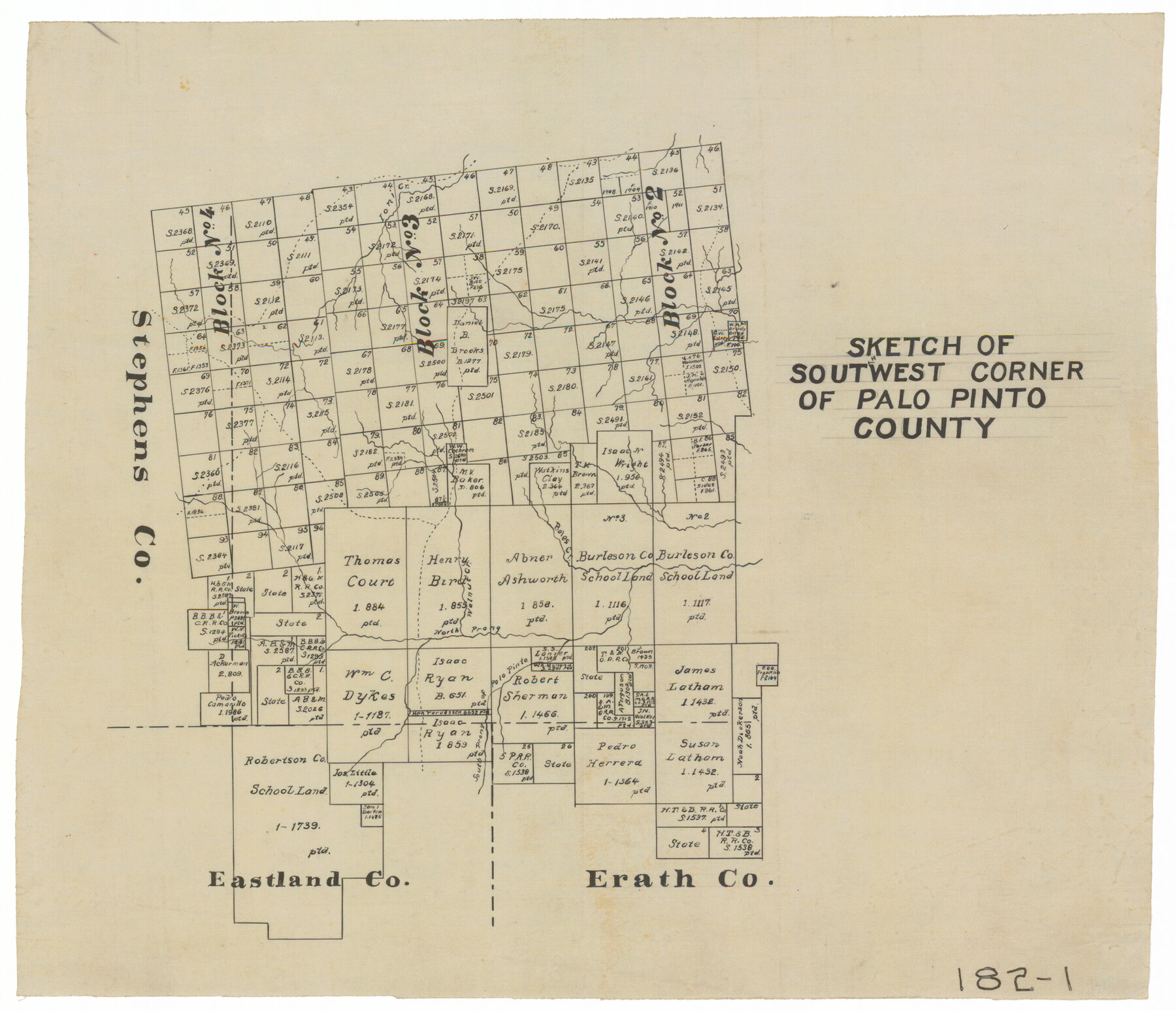
Sketch of Southwest Corner of Palo Pinto County
182-1
-
Map/Doc
91647
-
Collection
Twichell Survey Records
-
Counties
Palo Pinto Stephens
-
Height x Width
13.9 x 12.0 inches
35.3 x 30.5 cm
Part of: Twichell Survey Records
[Texas and Pacific Blocks 56-62, Townships 1-3]
![90501, [Texas and Pacific Blocks 56-62, Townships 1-3], Twichell Survey Records](https://historictexasmaps.com/wmedia_w700/maps/90501-1.tif.jpg)
Print $20.00
- Digital $50.00
[Texas and Pacific Blocks 56-62, Townships 1-3]
1885
Size 28.4 x 15.9 inches
Map/Doc 90501
Working Sketch Reeves County [showing Blocks 70-72, C-8, 9, 17-18, and Texas & Pacific RR Block 58]
![91770, Working Sketch Reeves County [showing Blocks 70-72, C-8, 9, 17-18, and Texas & Pacific RR Block 58], Twichell Survey Records](https://historictexasmaps.com/wmedia_w700/maps/91770-1.tif.jpg)
Print $20.00
- Digital $50.00
Working Sketch Reeves County [showing Blocks 70-72, C-8, 9, 17-18, and Texas & Pacific RR Block 58]
1908
Size 21.6 x 17.2 inches
Map/Doc 91770
Right-of-way & Track Map Dawson Railway Operated by the El Paso & Southwestern Company Station 1444+61.7 to Station 1655+23.4

Print $40.00
- Digital $50.00
Right-of-way & Track Map Dawson Railway Operated by the El Paso & Southwestern Company Station 1444+61.7 to Station 1655+23.4
1910
Size 56.7 x 24.8 inches
Map/Doc 89655
Houston & Great Northern Railroad, Block 2

Print $20.00
- Digital $50.00
Houston & Great Northern Railroad, Block 2
1921
Size 20.4 x 22.7 inches
Map/Doc 90720
Leagues 35, 36, 37, 38, 39, 40, 41, and 42]
![92236, Leagues 35, 36, 37, 38, 39, 40, 41, and 42], Twichell Survey Records](https://historictexasmaps.com/wmedia_w700/maps/92236-1.tif.jpg)
Print $20.00
- Digital $50.00
Leagues 35, 36, 37, 38, 39, 40, 41, and 42]
Size 40.4 x 34.4 inches
Map/Doc 92236
[Southwest 1/4 of Northwest 1/4 of County in vicinity of surveys 1281, 1282, 1297 and 1302]
![90897, [Southwest 1/4 of Northwest 1/4 of County in vicinity of surveys 1281, 1282, 1297 and 1302], Twichell Survey Records](https://historictexasmaps.com/wmedia_w700/maps/90897-1.tif.jpg)
Print $20.00
- Digital $50.00
[Southwest 1/4 of Northwest 1/4 of County in vicinity of surveys 1281, 1282, 1297 and 1302]
Size 21.5 x 14.2 inches
Map/Doc 90897
[G. C. & S. F. Railroad Company, Block S]
![91330, [G. C. & S. F. Railroad Company, Block S], Twichell Survey Records](https://historictexasmaps.com/wmedia_w700/maps/91330-1.tif.jpg)
Print $2.00
- Digital $50.00
[G. C. & S. F. Railroad Company, Block S]
Size 8.6 x 6.0 inches
Map/Doc 91330
Sketch of Northeast Part of Lamb County, Texas

Print $20.00
- Digital $50.00
Sketch of Northeast Part of Lamb County, Texas
Size 24.7 x 20.6 inches
Map/Doc 91062
![90262, [Block M10], Twichell Survey Records](https://historictexasmaps.com/wmedia_w700/maps/90262-1.tif.jpg)
North Tech Addition, Section 18, Block A

Print $20.00
- Digital $50.00
North Tech Addition, Section 18, Block A
1952
Size 17.9 x 23.0 inches
Map/Doc 92756
San Augustine County School Land for sale by Lubbock Irrigation Company

Print $20.00
- Digital $50.00
San Augustine County School Land for sale by Lubbock Irrigation Company
Size 23.4 x 24.8 inches
Map/Doc 92826
[H. & T. C. RR. Company Block 47, Sections 46, 47, 48, and 49]
![91220, [H. & T. C. RR. Company Block 47, Sections 46, 47, 48, and 49], Twichell Survey Records](https://historictexasmaps.com/wmedia_w700/maps/91220-1.tif.jpg)
Print $3.00
- Digital $50.00
[H. & T. C. RR. Company Block 47, Sections 46, 47, 48, and 49]
Size 9.4 x 11.4 inches
Map/Doc 91220
You may also like
Flight Mission No. DAG-23K, Frame 58, Matagorda County

Print $20.00
- Digital $50.00
Flight Mission No. DAG-23K, Frame 58, Matagorda County
1953
Size 18.4 x 22.3 inches
Map/Doc 86485
Madison County Working Sketch 10

Print $20.00
- Digital $50.00
Madison County Working Sketch 10
1960
Size 34.7 x 32.0 inches
Map/Doc 70772
General Highway Map, Cooke County, Texas

Print $20.00
General Highway Map, Cooke County, Texas
1961
Size 24.8 x 18.2 inches
Map/Doc 79421
Hutchinson County Rolled Sketch 8

Print $20.00
- Digital $50.00
Hutchinson County Rolled Sketch 8
Size 32.0 x 29.1 inches
Map/Doc 6279
Map of Tom Green County

Print $40.00
- Digital $50.00
Map of Tom Green County
1892
Size 42.9 x 48.2 inches
Map/Doc 63069
Galveston County NRC Article 33.136 Sketch 32

Print $26.00
- Digital $50.00
Galveston County NRC Article 33.136 Sketch 32
2005
Size 24.5 x 36.8 inches
Map/Doc 83173
Nueces River, Calallen Sheet

Print $20.00
- Digital $50.00
Nueces River, Calallen Sheet
1927
Size 32.7 x 37.3 inches
Map/Doc 65087
King County Working Sketch 18

Print $20.00
- Digital $50.00
King County Working Sketch 18
1994
Size 31.3 x 35.1 inches
Map/Doc 70182
Upton County Rolled Sketch 26

Print $20.00
- Digital $50.00
Upton County Rolled Sketch 26
1942
Size 35.7 x 37.2 inches
Map/Doc 10045
Tracing From [Melish's] Map with Kansas and the Panhandle of Texas plotted thereon Showing the disputed Territory
![76190, Tracing From [Melish's] Map with Kansas and the Panhandle of Texas plotted thereon Showing the disputed Territory, Texas State Library and Archives](https://historictexasmaps.com/wmedia_w700/maps/76190.tif.jpg)
Print $20.00
Tracing From [Melish's] Map with Kansas and the Panhandle of Texas plotted thereon Showing the disputed Territory
1818
Size 18.8 x 19.8 inches
Map/Doc 76190
[County School Land Leagues]
![90279, [County School Land Leagues], Twichell Survey Records](https://historictexasmaps.com/wmedia_w700/maps/90279-1.tif.jpg)
Print $20.00
- Digital $50.00
[County School Land Leagues]
1913
Size 21.1 x 27.7 inches
Map/Doc 90279
Winkler County Rolled Sketch 14

Print $20.00
- Digital $50.00
Winkler County Rolled Sketch 14
Size 25.9 x 38.4 inches
Map/Doc 8275