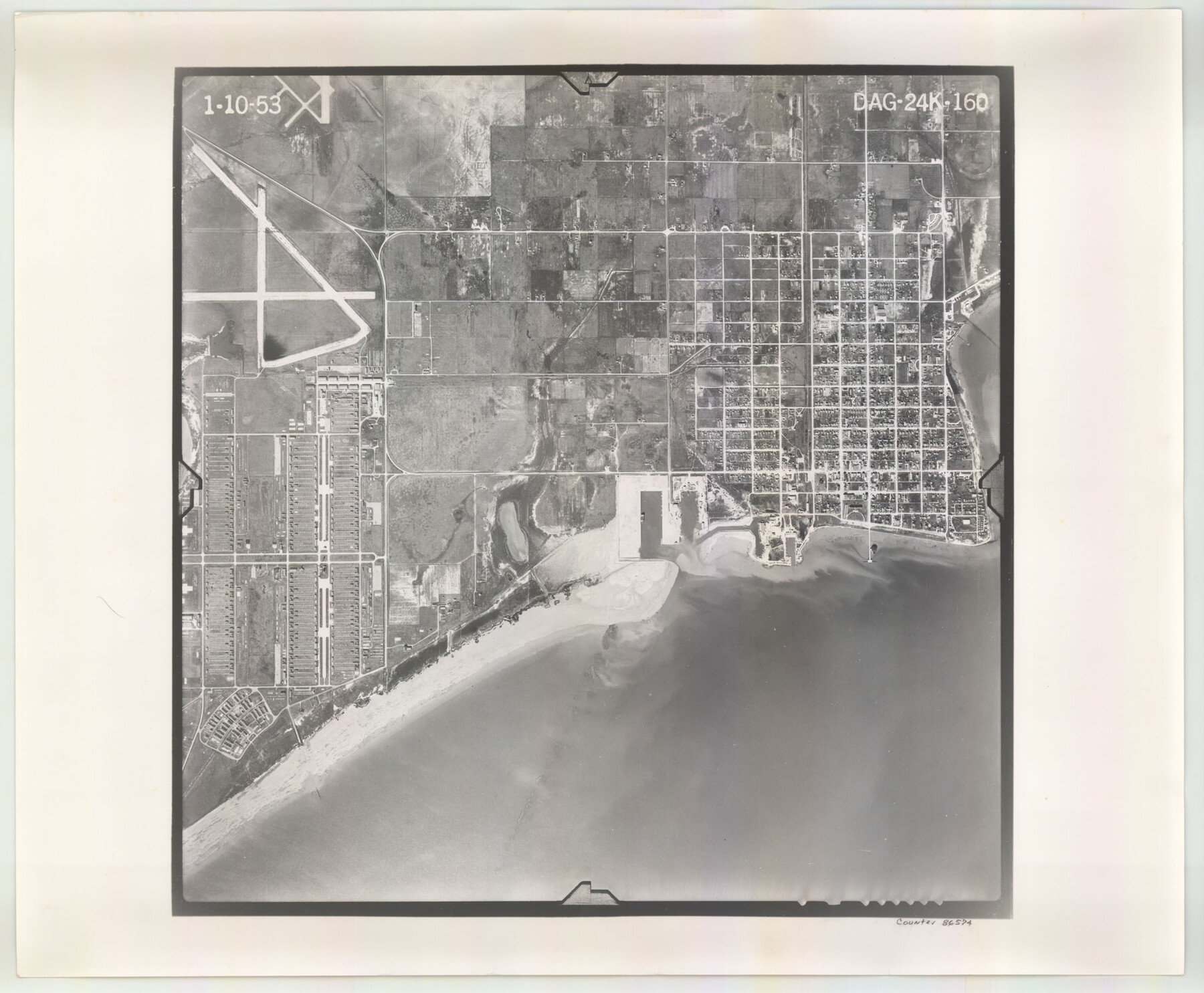
Flight Mission No. DAG-24K, Frame 160, Matagorda County
DAG-24K-160
-
Map/Doc
86574
-
Collection
General Map Collection
-
Object Dates
1953/1/10 (Creation Date)
-
People and Organizations
U. S. Department of Agriculture (Publisher)
-
Counties
Matagorda
-
Subjects
Aerial Photograph
-
Height x Width
18.6 x 22.5 inches
47.2 x 57.2 cm
-
Comments
Flown by Aero Exploration Company of Tulsa, Oklahoma.
Part of: General Map Collection
Austin County Working Sketch 4

Print $20.00
- Digital $50.00
Austin County Working Sketch 4
1959
Size 29.8 x 34.8 inches
Map/Doc 67245
Texas Land Commissioner George P. Bush's Energy Map of Texas Showing Significant Events and Well & Pipeline Locations Between 1543 and 2015

Print $20.00
- Digital $50.00
Texas Land Commissioner George P. Bush's Energy Map of Texas Showing Significant Events and Well & Pipeline Locations Between 1543 and 2015
2015
Size 33.3 x 36.3 inches
Map/Doc 93978
New Map of San Antonio, Texas

Print $20.00
- Digital $50.00
New Map of San Antonio, Texas
1920
Size 17.2 x 14.2 inches
Map/Doc 97156
Kimble County Rolled Sketch 20

Print $20.00
- Digital $50.00
Kimble County Rolled Sketch 20
Size 14.6 x 18.1 inches
Map/Doc 6511
Hill County Sketch File 14

Print $4.00
- Digital $50.00
Hill County Sketch File 14
Size 3.8 x 4.3 inches
Map/Doc 26480
Fayette County

Print $40.00
- Digital $50.00
Fayette County
1920
Size 42.7 x 49.8 inches
Map/Doc 4945
Swisher County Rolled Sketch 4

Print $20.00
- Digital $50.00
Swisher County Rolled Sketch 4
1904
Size 16.2 x 18.0 inches
Map/Doc 7905
Orange County Working Sketch 53

Print $20.00
- Digital $50.00
Orange County Working Sketch 53
2007
Size 34.1 x 46.0 inches
Map/Doc 87371
Gaines County Sketch File 11

Print $6.00
- Digital $50.00
Gaines County Sketch File 11
1943
Size 7.3 x 8.9 inches
Map/Doc 23195
Val Verde Co.

Print $20.00
- Digital $50.00
Val Verde Co.
1908
Size 39.8 x 38.7 inches
Map/Doc 63100
Haskell County Sketch File 13

Print $37.00
- Digital $50.00
Haskell County Sketch File 13
Size 8.1 x 4.0 inches
Map/Doc 26142
Webb County Sketch File 14

Print $7.00
- Digital $50.00
Webb County Sketch File 14
1877
Size 10.0 x 8.2 inches
Map/Doc 39807
You may also like
General Highway Map, Collingsworth County, Texas

Print $20.00
General Highway Map, Collingsworth County, Texas
1940
Size 18.3 x 25.2 inches
Map/Doc 79053
Texas Official Travel Map

Digital $50.00
Texas Official Travel Map
Size 33.5 x 36.2 inches
Map/Doc 94303
Sketch showing the Chas. M. Roberts 53 1/2 acres about 16 miles N of Houston, east of I.&G.N. R.R.

Print $2.00
- Digital $50.00
Sketch showing the Chas. M. Roberts 53 1/2 acres about 16 miles N of Houston, east of I.&G.N. R.R.
Size 8.0 x 5.9 inches
Map/Doc 374
Armstrong County

Print $20.00
- Digital $50.00
Armstrong County
1933
Size 42.3 x 41.0 inches
Map/Doc 73071
Uvalde County Working Sketch 27

Print $20.00
- Digital $50.00
Uvalde County Working Sketch 27
1957
Size 24.4 x 25.7 inches
Map/Doc 72097
Plat Showing the Development of Texas Counties from the Original Land Districts

Print $40.00
- Digital $50.00
Plat Showing the Development of Texas Counties from the Original Land Districts
Size 49.6 x 29.5 inches
Map/Doc 73616
Cochran County, Texas

Print $40.00
- Digital $50.00
Cochran County, Texas
Size 38.1 x 48.3 inches
Map/Doc 89870
Childress County Sketch File 15

Print $8.00
- Digital $50.00
Childress County Sketch File 15
Size 14.3 x 8.3 inches
Map/Doc 18278
Lipscomb County Boundary File 14a

Print $4.00
- Digital $50.00
Lipscomb County Boundary File 14a
Size 11.3 x 8.7 inches
Map/Doc 56368
Bell County Sketch File 33

Print $6.00
- Digital $50.00
Bell County Sketch File 33
Size 14.4 x 8.7 inches
Map/Doc 14452
Culberson County Sketch File 22

Print $6.00
- Digital $50.00
Culberson County Sketch File 22
1934
Size 11.8 x 8.8 inches
Map/Doc 20234
McMullen County Working Sketch 32

Print $20.00
- Digital $50.00
McMullen County Working Sketch 32
1958
Size 28.2 x 32.5 inches
Map/Doc 70733