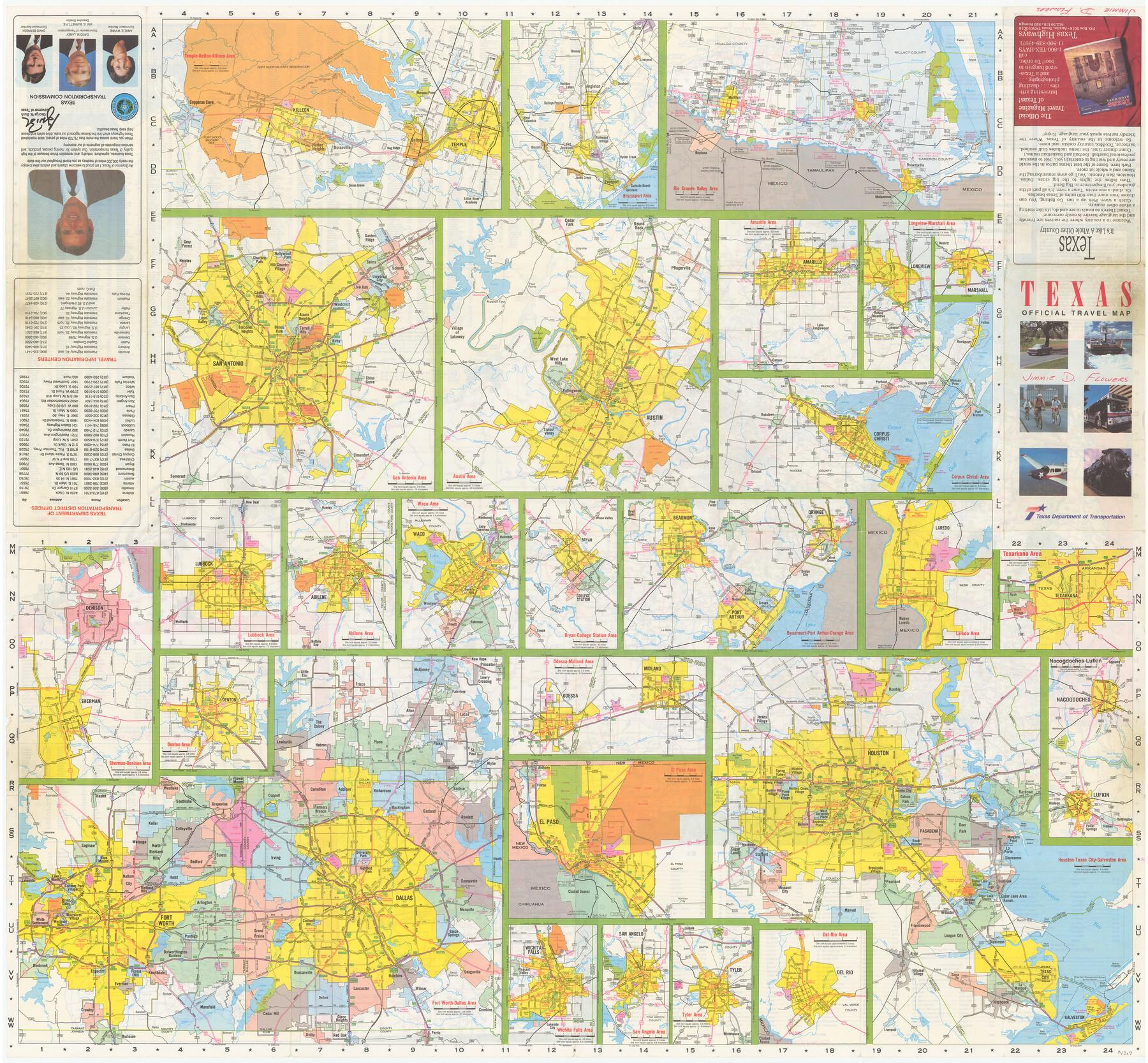
Texas Official Travel Map
[Recto - Various Texas Cities]
-
Map/Doc
94303
-
Collection
General Map Collection
-
Object Dates
1995 (Edition Date)
-
People and Organizations
Texas Department of Transportation (Publisher)
-
Subjects
City
-
Height x Width
33.5 x 36.2 inches
85.1 x 91.9 cm
-
Medium
paper, etching/engraving/lithograph
-
Comments
For map of Texas on verso see 94304. For reseach purposes only.
Related maps
Texas Official Travel Map

Digital $50.00
Texas Official Travel Map
Size 33.4 x 36.1 inches
Map/Doc 94304
Part of: General Map Collection
Navarro County Sketch File 3

Print $8.00
- Digital $50.00
Navarro County Sketch File 3
1847
Size 10.2 x 8.1 inches
Map/Doc 32300
Map of Cherokee County

Print $40.00
- Digital $50.00
Map of Cherokee County
1933
Size 59.9 x 41.5 inches
Map/Doc 1799
Harris County Sketch File A

Print $4.00
- Digital $50.00
Harris County Sketch File A
1898
Size 12.8 x 8.5 inches
Map/Doc 25306
McCulloch County Sketch File 14

Print $8.00
- Digital $50.00
McCulloch County Sketch File 14
1990
Size 11.2 x 8.7 inches
Map/Doc 31203
Sutton County Sketch File F

Print $18.00
- Digital $50.00
Sutton County Sketch File F
1906
Size 14.1 x 8.7 inches
Map/Doc 37391
Ochiltree County Sketch File 5

Print $4.00
- Digital $50.00
Ochiltree County Sketch File 5
Size 14.5 x 8.9 inches
Map/Doc 33184
Lynn County Rolled Sketch 14

Print $20.00
- Digital $50.00
Lynn County Rolled Sketch 14
1952
Size 35.4 x 35.3 inches
Map/Doc 9474
Presidio County Rolled Sketch 131B

Print $20.00
- Digital $50.00
Presidio County Rolled Sketch 131B
1993
Size 33.4 x 46.7 inches
Map/Doc 9803
Hutchinson County Sketch File 40

Print $32.00
- Digital $50.00
Hutchinson County Sketch File 40
Size 11.3 x 8.9 inches
Map/Doc 27282
Flight Mission No. DAG-17K, Frame 138, Matagorda County

Print $20.00
- Digital $50.00
Flight Mission No. DAG-17K, Frame 138, Matagorda County
1952
Size 18.5 x 22.2 inches
Map/Doc 86355
Matagorda County Rolled Sketch 35

Print $20.00
- Digital $50.00
Matagorda County Rolled Sketch 35
1903
Size 18.6 x 38.0 inches
Map/Doc 6696
Concho County

Print $20.00
- Digital $50.00
Concho County
1897
Size 45.9 x 38.0 inches
Map/Doc 66785
You may also like
Jim Hogg County Sketch File 5

Print $20.00
- Digital $50.00
Jim Hogg County Sketch File 5
1939
Size 24.8 x 19.9 inches
Map/Doc 11885
Blanco County Working Sketch 23

Print $40.00
- Digital $50.00
Blanco County Working Sketch 23
1962
Size 52.4 x 38.5 inches
Map/Doc 67383
Map of Denton County, Texas

Print $20.00
- Digital $50.00
Map of Denton County, Texas
Size 22.8 x 19.4 inches
Map/Doc 711
Real County Working Sketch 75

Print $20.00
- Digital $50.00
Real County Working Sketch 75
1979
Size 29.0 x 28.6 inches
Map/Doc 71967
Preliminary Chart of the Sea Coast of Texas in the Vicinity of Galveston

Print $20.00
Preliminary Chart of the Sea Coast of Texas in the Vicinity of Galveston
1856
Size 26.3 x 19.7 inches
Map/Doc 76256
Kendall County Sketch File 9

Print $6.00
- Digital $50.00
Kendall County Sketch File 9
1879
Size 4.6 x 9.3 inches
Map/Doc 28692
[Maps of surveys in Reeves & Culberson Cos]
![61148, [Maps of surveys in Reeves & Culberson Cos], General Map Collection](https://historictexasmaps.com/wmedia_w700/maps/61148.tif.jpg)
Print $20.00
- Digital $50.00
[Maps of surveys in Reeves & Culberson Cos]
1937
Size 30.7 x 24.9 inches
Map/Doc 61148
Bien & Sterner’s New Rail Road Map of the United States

Price $20.00
Bien & Sterner’s New Rail Road Map of the United States
2022
Size 3.6 x 4.9 inches
Map/Doc 97020
Crosby County Working Sketch 5

Print $20.00
- Digital $50.00
Crosby County Working Sketch 5
1911
Size 23.3 x 16.7 inches
Map/Doc 68439
Kendall County Sketch File 22

Print $20.00
- Digital $50.00
Kendall County Sketch File 22
1926
Size 17.0 x 25.8 inches
Map/Doc 11910
Flight Mission No. DQO-8K, Frame 71, Galveston County

Print $20.00
- Digital $50.00
Flight Mission No. DQO-8K, Frame 71, Galveston County
1952
Size 18.6 x 22.4 inches
Map/Doc 85175
![89854, [Lamesa], Twichell Survey Records](https://historictexasmaps.com/wmedia_w700/maps/89854-1.tif.jpg)