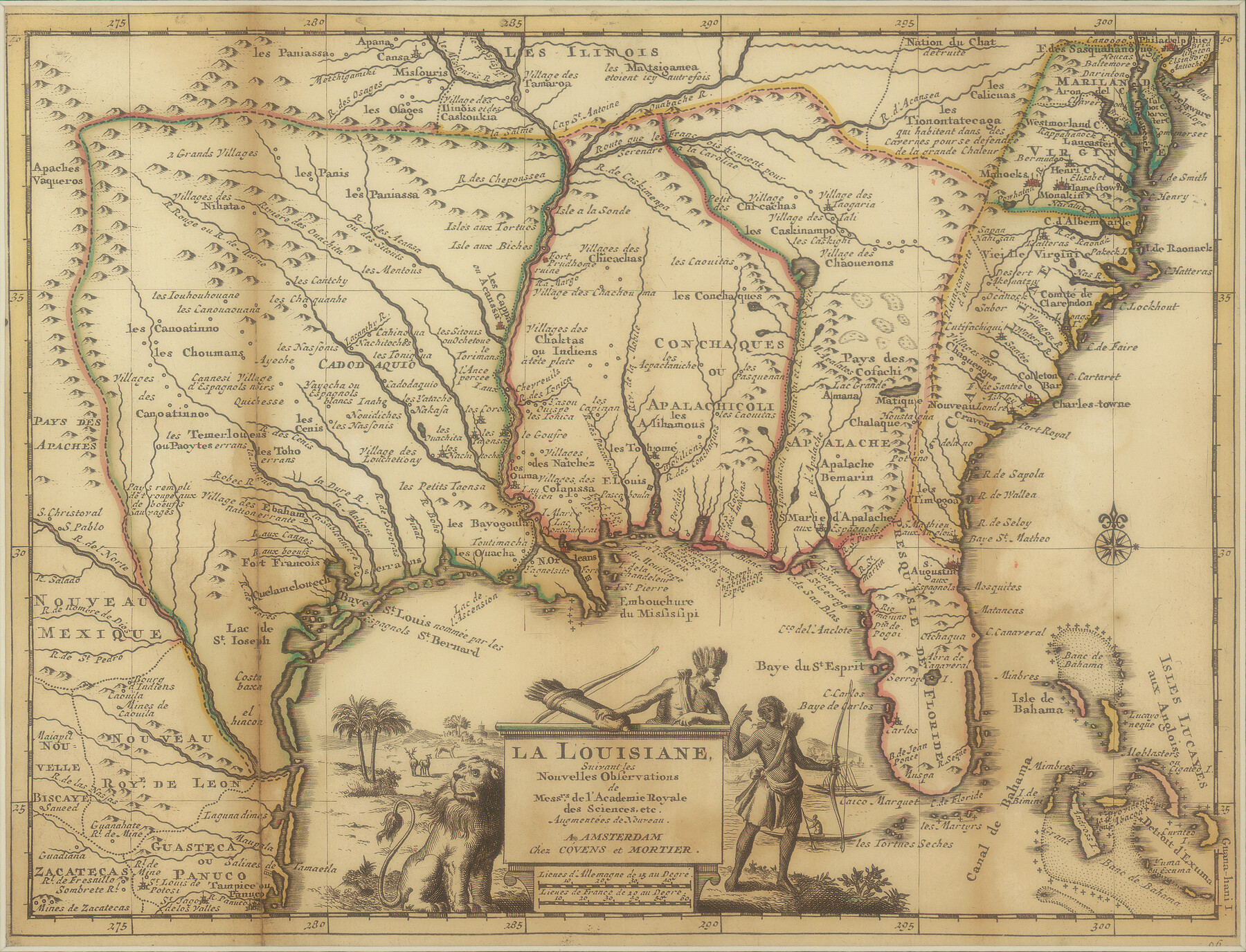
La Louisiane, Suivant les Nouvelles Observations de Messrs de l'Academie Royale des Sciences
-
Map/Doc
95279
-
Collection
Non-GLO Digital Images
-
Object Dates
[1735 ca.] (Creation Date)
-
People and Organizations
Covens et Mortier (Publisher)
J. Covens (Publisher)
C. Mortier (Publisher)
-
Subjects
North America
-
Height x Width
9.1 x 11.9 inches
23.1 x 30.2 cm
-
Medium
digital image
-
Comments
Digital image courtesy of an anonymous supporter of the Texas General Land Office in 2018.
Part of: Non-GLO Digital Images
Bird's Eye View of the City of Austin, Travis County, Texas

Print $20.00
Bird's Eye View of the City of Austin, Travis County, Texas
1873
Size 21.3 x 28.7 inches
Map/Doc 89217

J. De Cordova's Map of the State of Texas Compiled from the records of the General Land Office of the State

Print $20.00
J. De Cordova's Map of the State of Texas Compiled from the records of the General Land Office of the State
1849
Size 35.7 x 33.6 inches
Map/Doc 93964
Carte de la Louisiane et Pays Voisins Pour servir a l'Histoire Generale des Voyages

Print $20.00
Carte de la Louisiane et Pays Voisins Pour servir a l'Histoire Generale des Voyages
1757
Size 9.6 x 14.9 inches
Map/Doc 94572
Clarendon, Texas, Donley Co.

Print $20.00
Clarendon, Texas, Donley Co.
1890
Size 15.7 x 26.6 inches
Map/Doc 89078
Plan of New Orleans

Print $20.00
- Digital $50.00
Plan of New Orleans
1860
Size 12.8 x 15.7 inches
Map/Doc 95910
Houston, Texas (Looking South)

Print $20.00
Houston, Texas (Looking South)
1891
Size 25.3 x 41.1 inches
Map/Doc 89094
The Official Map of the City of El Paso, State of Texas

Print $20.00
The Official Map of the City of El Paso, State of Texas
1889
Size 41.9 x 46.2 inches
Map/Doc 89618
Carte de la Louisiane et du Cours du Mississipi

Print $20.00
Carte de la Louisiane et du Cours du Mississipi
1718
Size 16.6 x 21.8 inches
Map/Doc 89216
Map of the territory comprised between the Province of New Mexico and the fort of Natchitoches and Texas

Map of the territory comprised between the Province of New Mexico and the fort of Natchitoches and Texas
1789
Size 8.9 x 15.3 inches
Map/Doc 88888
Bird's Eye View of the City of San Antonio, Bexar County, Texas

Print $20.00
Bird's Eye View of the City of San Antonio, Bexar County, Texas
1873
Size 23.9 x 29.6 inches
Map/Doc 89203

You may also like
Wharton County Working Sketch 24

Print $20.00
- Digital $50.00
Wharton County Working Sketch 24
1909
Size 13.3 x 14.2 inches
Map/Doc 72488
General Highway Map, Pecos County, Texas

Print $20.00
General Highway Map, Pecos County, Texas
1961
Size 24.5 x 18.1 inches
Map/Doc 79627
Karnes County Boundary File 1

Print $14.00
- Digital $50.00
Karnes County Boundary File 1
Size 8.5 x 7.0 inches
Map/Doc 55679
Burnet County Sketch File 20

Print $4.00
- Digital $50.00
Burnet County Sketch File 20
1862
Size 10.1 x 8.0 inches
Map/Doc 16712
Reagan County Rolled Sketch 29

Print $20.00
- Digital $50.00
Reagan County Rolled Sketch 29
1954
Size 35.6 x 35.4 inches
Map/Doc 9824

Live Oak County Working Sketch 33

Print $20.00
- Digital $50.00
Live Oak County Working Sketch 33
1992
Size 25.9 x 35.1 inches
Map/Doc 70618
Gregg County Rolled Sketch 23

Print $40.00
- Digital $50.00
Gregg County Rolled Sketch 23
Size 52.9 x 43.3 inches
Map/Doc 9074
Terrell County Rolled Sketch 37

Print $20.00
- Digital $50.00
Terrell County Rolled Sketch 37
1940
Size 23.8 x 33.3 inches
Map/Doc 7941
[Gunter & Munson and Surrounding Surveys]
![91238, [Gunter & Munson and Surrounding Surveys], Twichell Survey Records](https://historictexasmaps.com/wmedia_w700/maps/91238-1.tif.jpg)
Print $20.00
- Digital $50.00
[Gunter & Munson and Surrounding Surveys]
Size 16.3 x 21.4 inches
Map/Doc 91238
Menard County Sketch File 5

Print $20.00
- Digital $50.00
Menard County Sketch File 5
Size 5.6 x 43.3 inches
Map/Doc 10542
Medina County Working Sketch 24

Print $20.00
- Digital $50.00
Medina County Working Sketch 24
1984
Size 26.1 x 36.7 inches
Map/Doc 70939