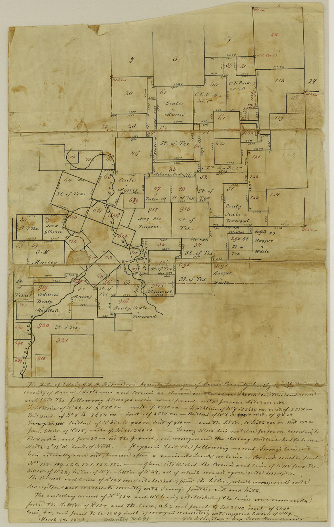
Mason County Sketch File 8
[Sketch of area in the southeast corner of Mason County]
-
Map/Doc
30691
-
Collection
General Map Collection
-
Object Dates
3/14/1876 (Creation Date)
-
People and Organizations
H.R. Biberstein (Surveyor/Engineer)
-
Counties
Mason Gillespie
-
Subjects
Surveying Sketch File
-
Height x Width
13.2 x 8.4 inches
33.5 x 21.3 cm
-
Medium
paper, manuscript
-
Features
Squaw Creek
Beaver Creek
Treadgill [sic] Creek
Part of: General Map Collection
Reeves County Working Sketch 41

Print $40.00
- Digital $50.00
Reeves County Working Sketch 41
1973
Size 42.5 x 53.4 inches
Map/Doc 63484
Wharton County Rolled Sketch 3

Print $20.00
- Digital $50.00
Wharton County Rolled Sketch 3
Size 28.9 x 31.4 inches
Map/Doc 8228
Hardin County Working Sketch 19

Print $20.00
- Digital $50.00
Hardin County Working Sketch 19
1947
Size 28.9 x 34.3 inches
Map/Doc 63417
Baylor County Rolled Sketch 12

Print $20.00
- Digital $50.00
Baylor County Rolled Sketch 12
1986
Size 22.4 x 36.0 inches
Map/Doc 5129
Pecos County Working Sketch 42

Print $20.00
- Digital $50.00
Pecos County Working Sketch 42
1942
Size 31.3 x 23.9 inches
Map/Doc 71514
Flight Mission No. BQY-4M, Frame 40, Harris County

Print $20.00
- Digital $50.00
Flight Mission No. BQY-4M, Frame 40, Harris County
1953
Size 18.6 x 22.3 inches
Map/Doc 85255
Young County Sketch File 9a

Print $4.00
- Digital $50.00
Young County Sketch File 9a
1875
Size 12.9 x 8.3 inches
Map/Doc 40866
Houston County Sketch File 9

Print $4.00
- Digital $50.00
Houston County Sketch File 9
1857
Size 12.7 x 8.1 inches
Map/Doc 26771
San Patricio County Rolled Sketch 39

Print $20.00
- Digital $50.00
San Patricio County Rolled Sketch 39
1961
Size 40.4 x 31.7 inches
Map/Doc 7725
Menard County Working Sketch 32

Print $20.00
- Digital $50.00
Menard County Working Sketch 32
1987
Size 35.8 x 33.8 inches
Map/Doc 70979
Pecos County Sketch File 78

Print $6.00
- Digital $50.00
Pecos County Sketch File 78
1943
Size 11.1 x 8.8 inches
Map/Doc 33911
Sterling County Sketch File 2

Print $6.00
- Digital $50.00
Sterling County Sketch File 2
Size 10.7 x 15.6 inches
Map/Doc 37113
You may also like
Current Miscellaneous File 52

Print $12.00
- Digital $50.00
Current Miscellaneous File 52
1953
Size 12.3 x 9.3 inches
Map/Doc 74032
Crockett County Rolled Sketch 48

Print $20.00
- Digital $50.00
Crockett County Rolled Sketch 48
1939
Size 30.0 x 40.3 inches
Map/Doc 8712
Flight Mission No. CRC-3R, Frame 37, Chambers County

Print $20.00
- Digital $50.00
Flight Mission No. CRC-3R, Frame 37, Chambers County
1956
Size 18.6 x 22.4 inches
Map/Doc 84810
Railroad and County Map of Texas

Print $20.00
- Digital $50.00
Railroad and County Map of Texas
1887
Size 18.0 x 23.9 inches
Map/Doc 93959
Duval County Sketch File 4c1

Print $4.00
- Digital $50.00
Duval County Sketch File 4c1
1874
Size 10.4 x 7.9 inches
Map/Doc 21286
Upton County Rolled Sketch 12A

Print $20.00
- Digital $50.00
Upton County Rolled Sketch 12A
1913
Size 29.7 x 37.8 inches
Map/Doc 8069
Plat in Pecos County, Texas

Print $40.00
- Digital $50.00
Plat in Pecos County, Texas
1927
Size 58.3 x 37.9 inches
Map/Doc 89877
Delta County Working Sketch 4

Print $20.00
- Digital $50.00
Delta County Working Sketch 4
Size 16.8 x 21.1 inches
Map/Doc 62179
Tom Green County Sketch File 13

Print $4.00
- Digital $50.00
Tom Green County Sketch File 13
Size 6.3 x 8.4 inches
Map/Doc 38170
Map of the Country Upon Upper Red River Explored in 1852

Print $20.00
Map of the Country Upon Upper Red River Explored in 1852
1852
Size 17.2 x 34.9 inches
Map/Doc 79726
A New Map of ye North Parts of America according to the division thereof by the Articles of Peace in 1763

Print $20.00
A New Map of ye North Parts of America according to the division thereof by the Articles of Peace in 1763
1763
Size 8.5 x 11.3 inches
Map/Doc 95280
Galveston County Sketch File 66

Print $116.00
- Digital $50.00
Galveston County Sketch File 66
Size 5.0 x 10.0 inches
Map/Doc 23751