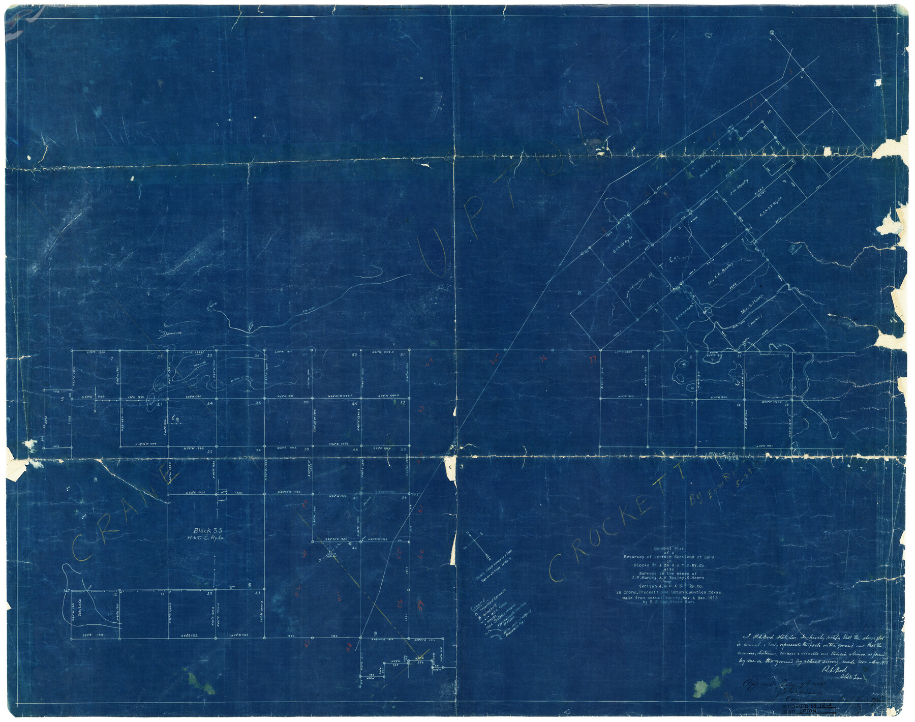
Upton County Rolled Sketch 12A
General plat of a resurvey of certain sections of land in Blocks 35 & 36, H. & T. C. Ry. Co. also surveys in the names of J.W. Murphy, A.E. Baxley, S. Hearn and section 4, G. C. & S. F. Ry. Co. in Crane, Crockett, and Upton Counties, Texas
-
Map/Doc
8069
-
Collection
General Map Collection
-
Object Dates
12/1913 (Creation Date)
2/9/1914 (File Date)
-
People and Organizations
R.S. Dod (Surveyor/Engineer)
-
Counties
Upton Crane Crockett
-
Subjects
Surveying Rolled Sketch
-
Height x Width
29.7 x 37.8 inches
75.4 x 96.0 cm
-
Medium
blueprint/diazo
Part of: General Map Collection
Flight Mission No. CUG-3P, Frame 192, Kleberg County

Print $20.00
- Digital $50.00
Flight Mission No. CUG-3P, Frame 192, Kleberg County
1956
Size 18.4 x 22.2 inches
Map/Doc 86296
Central & Montgomery

Print $20.00
- Digital $50.00
Central & Montgomery
1941
Size 24.9 x 24.2 inches
Map/Doc 64524
Texas Official Travel Map

Digital $50.00
Texas Official Travel Map
Size 33.6 x 36.5 inches
Map/Doc 94301
Tyler County Sketch File 3

Print $10.00
- Digital $50.00
Tyler County Sketch File 3
1855
Size 8.5 x 8.0 inches
Map/Doc 38622
Childress County Working Sketch 3

Print $20.00
- Digital $50.00
Childress County Working Sketch 3
1927
Size 22.4 x 18.6 inches
Map/Doc 68019
Brown County State Real Property Sketch 1

Print $80.00
- Digital $50.00
Brown County State Real Property Sketch 1
2018
Size 48.0 x 36.0 inches
Map/Doc 95204
Pecos County Working Sketch 82

Print $20.00
- Digital $50.00
Pecos County Working Sketch 82
1961
Size 38.6 x 36.7 inches
Map/Doc 71554
Kleberg County Rolled Sketch 10-15

Print $20.00
- Digital $50.00
Kleberg County Rolled Sketch 10-15
1951
Size 37.4 x 33.1 inches
Map/Doc 9367
[Surveys in the Bexar District along the Nueces and Leona Rivers]
![116, [Surveys in the Bexar District along the Nueces and Leona Rivers], General Map Collection](https://historictexasmaps.com/wmedia_w700/maps/116.tif.jpg)
Print $3.00
- Digital $50.00
[Surveys in the Bexar District along the Nueces and Leona Rivers]
1845
Size 10.9 x 14.3 inches
Map/Doc 116
Gray County Sketch File 6

Print $20.00
- Digital $50.00
Gray County Sketch File 6
1882
Size 26.3 x 21.4 inches
Map/Doc 11575
Map of the Houston & Tex. Cen. R.R. from Dallas, Dallas Co., to McKinney, Collin Co.

Print $20.00
- Digital $50.00
Map of the Houston & Tex. Cen. R.R. from Dallas, Dallas Co., to McKinney, Collin Co.
1873
Size 23.0 x 43.8 inches
Map/Doc 64474
San Patricio County Sketch File 40

Print $4.00
- Digital $50.00
San Patricio County Sketch File 40
1842
Size 10.5 x 8.2 inches
Map/Doc 36236
You may also like
[I. & G. N. Block 1]
![91572, [I. & G. N. Block 1], Twichell Survey Records](https://historictexasmaps.com/wmedia_w700/maps/91572-1.tif.jpg)
Print $20.00
- Digital $50.00
[I. & G. N. Block 1]
Size 17.5 x 13.6 inches
Map/Doc 91572
Somervell County Sketch File 4

Print $4.00
- Digital $50.00
Somervell County Sketch File 4
Size 6.4 x 8.8 inches
Map/Doc 36800
Kendall County Sketch File 23

Print $40.00
- Digital $50.00
Kendall County Sketch File 23
1938
Size 15.5 x 15.9 inches
Map/Doc 28716
Map of Public Roads in Terry County, Texas

Print $20.00
- Digital $50.00
Map of Public Roads in Terry County, Texas
Size 34.0 x 36.1 inches
Map/Doc 91941
Leon County Working Sketch 8

Print $20.00
- Digital $50.00
Leon County Working Sketch 8
1931
Size 28.9 x 42.8 inches
Map/Doc 70407
[Brooks & Burleson Block 4, Hartley County]
![5037, [Brooks & Burleson Block 4, Hartley County], Maddox Collection](https://historictexasmaps.com/wmedia_w700/maps/5037.tif.jpg)
Print $3.00
- Digital $50.00
[Brooks & Burleson Block 4, Hartley County]
Size 10.3 x 9.5 inches
Map/Doc 5037
Childress County Rolled Sketch 1

Print $20.00
- Digital $50.00
Childress County Rolled Sketch 1
Size 31.2 x 26.5 inches
Map/Doc 5437
Montgomery County Rolled Sketch 13A

Print $20.00
- Digital $50.00
Montgomery County Rolled Sketch 13A
1932
Size 17.7 x 27.5 inches
Map/Doc 6802
Loving County State of Texas

Print $20.00
- Digital $50.00
Loving County State of Texas
1889
Size 20.5 x 24.5 inches
Map/Doc 4581
North Part Brewster Co.

Print $40.00
- Digital $50.00
North Part Brewster Co.
1914
Size 48.4 x 37.8 inches
Map/Doc 89864
Right-of-Way and Track Map, Houston and Brazos Valley Ry. Co. operated by the Houston and Brazos Valley Ry. Co.

Print $40.00
- Digital $50.00
Right-of-Way and Track Map, Houston and Brazos Valley Ry. Co. operated by the Houston and Brazos Valley Ry. Co.
1918
Size 24.9 x 56.5 inches
Map/Doc 64607
Baylor County

Print $20.00
- Digital $50.00
Baylor County
1917
Size 47.3 x 40.7 inches
Map/Doc 66712