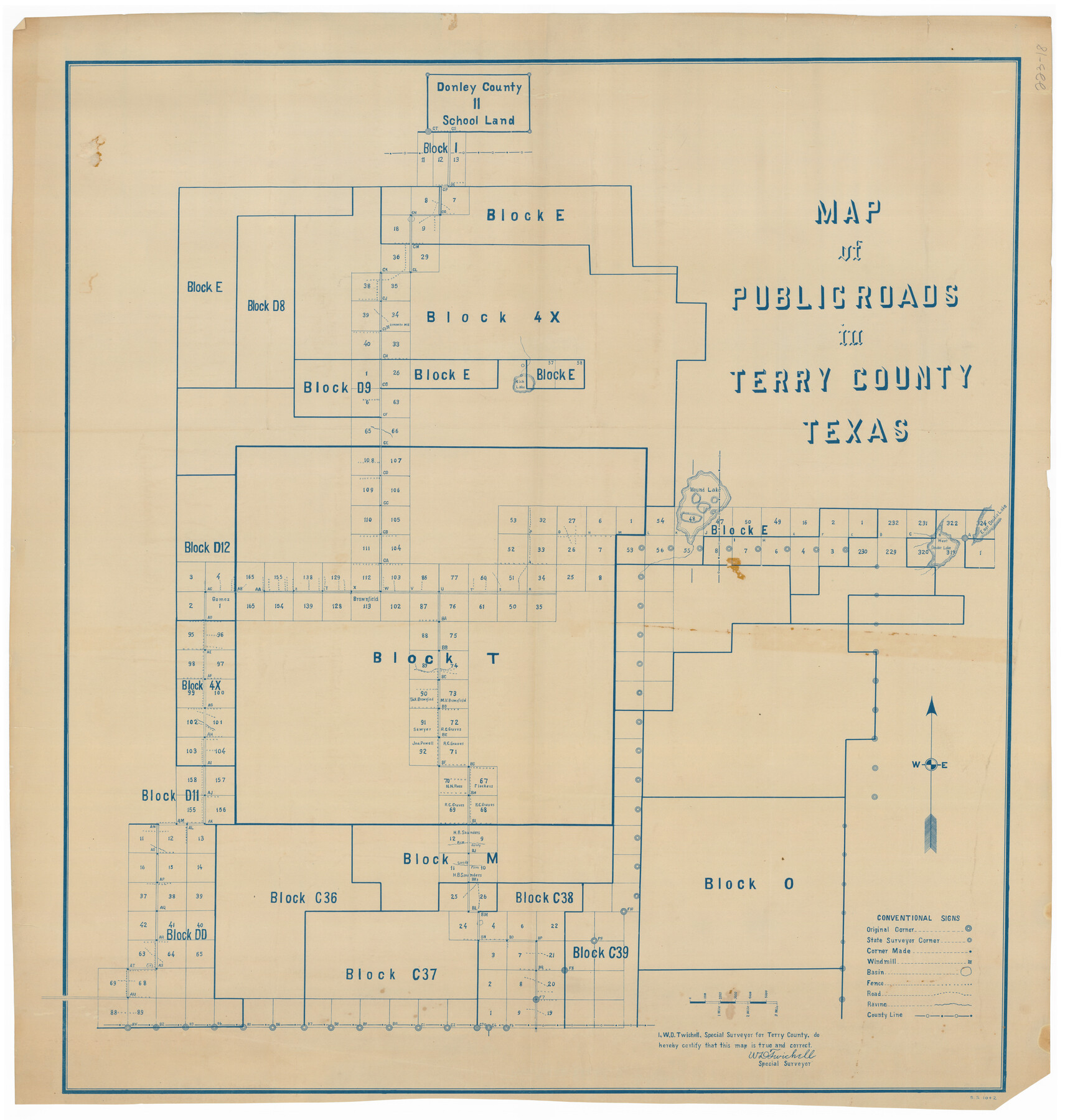
Map of Public Roads in Terry County, Texas
223-18
-
Map/Doc
91941
-
Collection
Twichell Survey Records
-
People and Organizations
W.D. Twichell (Surveyor/Engineer)
-
Counties
Terry Lynn
-
Height x Width
34.0 x 36.1 inches
86.4 x 91.7 cm
Part of: Twichell Survey Records
G&H Blocks Gaines Co. Resurvey 1915

Print $40.00
- Digital $50.00
G&H Blocks Gaines Co. Resurvey 1915
1915
Size 56.8 x 31.3 inches
Map/Doc 89632
Roberts Addition to the City of Morton

Print $3.00
- Digital $50.00
Roberts Addition to the City of Morton
1958
Size 11.8 x 11.4 inches
Map/Doc 92540
D. B. Gardner vs. Mrs. Clara C. Starr, Details 1, 2, 3, and 4

Print $20.00
- Digital $50.00
D. B. Gardner vs. Mrs. Clara C. Starr, Details 1, 2, 3, and 4
Size 25.1 x 30.0 inches
Map/Doc 91045
[Blocks T1, T2, T3, S3, A, 05, 02 and vicinity]
![92196, [Blocks T1, T2, T3, S3, A, 05, 02 and vicinity], Twichell Survey Records](https://historictexasmaps.com/wmedia_w700/maps/92196-1.tif.jpg)
Print $20.00
- Digital $50.00
[Blocks T1, T2, T3, S3, A, 05, 02 and vicinity]
Size 20.3 x 22.9 inches
Map/Doc 92196
Working Sketch in Eastland County

Print $20.00
- Digital $50.00
Working Sketch in Eastland County
1919
Size 20.1 x 14.6 inches
Map/Doc 90931
[Plat map showing mostly Overton Addition]
![92812, [Plat map showing mostly Overton Addition], Twichell Survey Records](https://historictexasmaps.com/wmedia_w700/maps/92812-1.tif.jpg)
Print $20.00
- Digital $50.00
[Plat map showing mostly Overton Addition]
Size 31.9 x 31.3 inches
Map/Doc 92812
Property Line Map, Low Rent Housing Project Texas 18-1, Housing Authority of the City of Lubbock

Print $20.00
- Digital $50.00
Property Line Map, Low Rent Housing Project Texas 18-1, Housing Authority of the City of Lubbock
1941
Size 42.2 x 27.9 inches
Map/Doc 92753
[Map Showing Fence Line between Blocks XIT and LS]
![91408, [Map Showing Fence Line between Blocks XIT and LS], Twichell Survey Records](https://historictexasmaps.com/wmedia_w700/maps/91408-1.tif.jpg)
Print $20.00
- Digital $50.00
[Map Showing Fence Line between Blocks XIT and LS]
1886
Size 18.4 x 16.7 inches
Map/Doc 91408
[Rusk, Sutton, and Atascosa County School Lands]
![91124, [Rusk, Sutton, and Atascosa County School Lands], Twichell Survey Records](https://historictexasmaps.com/wmedia_w700/maps/91124-1.tif.jpg)
Print $2.00
- Digital $50.00
[Rusk, Sutton, and Atascosa County School Lands]
Size 6.0 x 7.1 inches
Map/Doc 91124
[John S. Stephens Blk. S2, Lgs. 174-177, 186-193, 201-209]
![90107, [John S. Stephens Blk. S2, Lgs. 174-177, 186-193, 201-209], Twichell Survey Records](https://historictexasmaps.com/wmedia_w700/maps/90107-1.tif.jpg)
Print $2.00
- Digital $50.00
[John S. Stephens Blk. S2, Lgs. 174-177, 186-193, 201-209]
1912
Size 11.4 x 9.0 inches
Map/Doc 90107
[Map of Portion of Pecos County as Surveyed by F. F. Friend]
![91563, [Map of Portion of Pecos County as Surveyed by F. F. Friend], Twichell Survey Records](https://historictexasmaps.com/wmedia_w700/maps/91563-1.tif.jpg)
Print $20.00
- Digital $50.00
[Map of Portion of Pecos County as Surveyed by F. F. Friend]
1926
Size 17.3 x 13.9 inches
Map/Doc 91563
Ownership Map NE 1/4 Lubbock County

Print $20.00
- Digital $50.00
Ownership Map NE 1/4 Lubbock County
Size 37.5 x 39.8 inches
Map/Doc 89896
You may also like
Lamb County Boundary File 2

Print $102.00
- Digital $50.00
Lamb County Boundary File 2
Size 15.4 x 9.1 inches
Map/Doc 56057
La Salle County Rolled Sketch 8

Print $20.00
- Digital $50.00
La Salle County Rolled Sketch 8
Size 21.4 x 43.9 inches
Map/Doc 6571
Coryell County Working Sketch 3

Print $20.00
- Digital $50.00
Coryell County Working Sketch 3
1928
Size 23.6 x 22.5 inches
Map/Doc 68210
Cameron County Sketch File 7a

Print $32.00
- Digital $50.00
Cameron County Sketch File 7a
1982
Size 11.2 x 8.4 inches
Map/Doc 17115
Map of Panama, Texas

Print $5.00
- Digital $50.00
Map of Panama, Texas
1908
Size 10.4 x 15.6 inches
Map/Doc 94104
El Paso County Sketch File 18

Print $20.00
- Digital $50.00
El Paso County Sketch File 18
Size 19.0 x 23.8 inches
Map/Doc 11454
Montgomery County Rolled Sketch 26A

Print $20.00
- Digital $50.00
Montgomery County Rolled Sketch 26A
1941
Size 26.9 x 36.8 inches
Map/Doc 6808

Brazoria County Sketch File 10a

Print $50.00
- Digital $50.00
Brazoria County Sketch File 10a
1912
Size 7.1 x 8.7 inches
Map/Doc 14940
Shackelford County Working Sketch Graphic Index

Print $20.00
- Digital $50.00
Shackelford County Working Sketch Graphic Index
1972
Size 42.2 x 36.1 inches
Map/Doc 76696
Lampasas County Working Sketch 20

Print $20.00
- Digital $50.00
Lampasas County Working Sketch 20
1981
Size 26.0 x 31.9 inches
Map/Doc 70297
