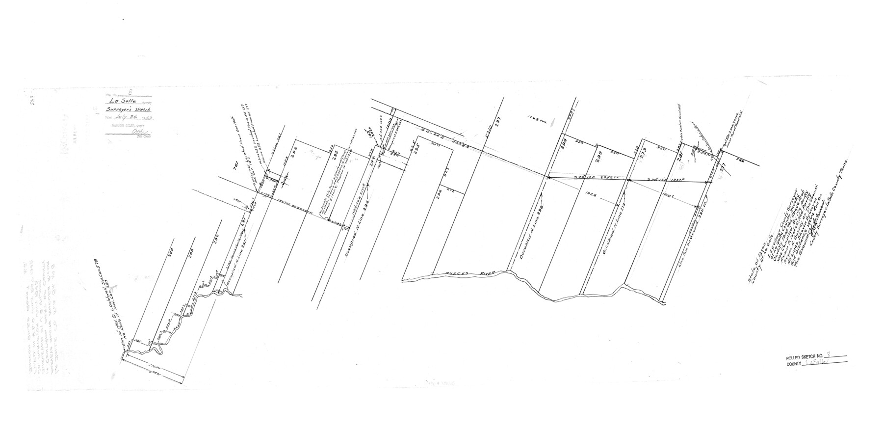
La Salle County Rolled Sketch 8
[Sketch of surveys along Nueces River in central part of La Salle County, Texas]
-
Map/Doc
6571
-
Collection
General Map Collection
-
Object Dates
1942/7/24 (File Date)
-
People and Organizations
J.G. Gilmer (Surveyor/Engineer)
-
Counties
La Salle
-
Subjects
Surveying Rolled Sketch
-
Height x Width
21.4 x 43.9 inches
54.4 x 111.5 cm
Part of: General Map Collection
Flight Mission No. BRE-1P, Frame 117, Nueces County

Print $20.00
- Digital $50.00
Flight Mission No. BRE-1P, Frame 117, Nueces County
1956
Size 18.4 x 22.3 inches
Map/Doc 86683
Pecos County Working Sketch 25

Print $20.00
- Digital $50.00
Pecos County Working Sketch 25
1929
Size 28.9 x 21.1 inches
Map/Doc 71496
South Part Crockett County

Print $40.00
- Digital $50.00
South Part Crockett County
1977
Size 39.1 x 51.2 inches
Map/Doc 95471
Montgomery County Rolled Sketch 43

Print $20.00
- Digital $50.00
Montgomery County Rolled Sketch 43
1971
Size 32.1 x 34.3 inches
Map/Doc 6822
[List of W.C. RR. Co. Certificates]
![60504, [List of W.C. RR. Co. Certificates], General Map Collection](https://historictexasmaps.com/wmedia_w700/pdf_converted_jpg/qi_pdf_thumbnail_17018.jpg)
Print $28.00
[List of W.C. RR. Co. Certificates]
1930
Size 14.4 x 8.9 inches
Map/Doc 60504
Padre Island National Seashore, Texas - Dependent Resurvey

Print $4.00
- Digital $50.00
Padre Island National Seashore, Texas - Dependent Resurvey
2001
Size 18.4 x 24.1 inches
Map/Doc 60553
Motley County Boundary File 2e

Print $40.00
- Digital $50.00
Motley County Boundary File 2e
Size 29.4 x 96.1 inches
Map/Doc 57561
Hutchinson County Working Sketch 11

Print $20.00
- Digital $50.00
Hutchinson County Working Sketch 11
1924
Size 20.4 x 29.4 inches
Map/Doc 66369
Map of Washington District

Print $20.00
- Digital $50.00
Map of Washington District
1847
Size 17.6 x 26.8 inches
Map/Doc 4125
Maverick County Working Sketch Graphic Index

Print $20.00
- Digital $50.00
Maverick County Working Sketch Graphic Index
1947
Size 46.4 x 30.3 inches
Map/Doc 76635
Pecos County Working Sketch 18

Print $20.00
- Digital $50.00
Pecos County Working Sketch 18
1917
Size 18.4 x 20.9 inches
Map/Doc 71488
Kimble County Rolled Sketch 23

Print $20.00
- Digital $50.00
Kimble County Rolled Sketch 23
Size 16.0 x 21.0 inches
Map/Doc 6513
You may also like
Flight Mission No. BRA-16M, Frame 73, Jefferson County

Print $20.00
- Digital $50.00
Flight Mission No. BRA-16M, Frame 73, Jefferson County
1953
Size 18.7 x 22.3 inches
Map/Doc 85690
Starr County Sketch File 26

Print $20.00
- Digital $50.00
Starr County Sketch File 26
1923
Size 31.7 x 27.2 inches
Map/Doc 10607
Wichita County Sketch File 35

Print $8.00
- Digital $50.00
Wichita County Sketch File 35
1950
Size 14.3 x 8.5 inches
Map/Doc 40157
General Highway Map Travis County

Print $20.00
- Digital $50.00
General Highway Map Travis County
1952
Size 17.2 x 12.5 inches
Map/Doc 92288
[Southeast part of Block D and Blocks DD, C31-C37, AX, G and H]
![92012, [Southeast part of Block D and Blocks DD, C31-C37, AX, G and H], Twichell Survey Records](https://historictexasmaps.com/wmedia_w700/maps/92012-1.tif.jpg)
Print $20.00
- Digital $50.00
[Southeast part of Block D and Blocks DD, C31-C37, AX, G and H]
Size 21.4 x 15.0 inches
Map/Doc 92012
[I. & G. N. RR. Co. Blk. 6, Blks M8, M9 and M10]
![90267, [I. & G. N. RR. Co. Blk. 6, Blks M8, M9 and M10], Twichell Survey Records](https://historictexasmaps.com/wmedia_w700/maps/90267-1.tif.jpg)
Print $20.00
- Digital $50.00
[I. & G. N. RR. Co. Blk. 6, Blks M8, M9 and M10]
Size 34.2 x 20.3 inches
Map/Doc 90267
Midland County Working Sketch 19

Print $20.00
- Digital $50.00
Midland County Working Sketch 19
1953
Size 29.9 x 24.7 inches
Map/Doc 70999
Parker County Working Sketch 28

Print $20.00
- Digital $50.00
Parker County Working Sketch 28
2009
Map/Doc 89011
Blanco County Boundary File 8

Print $20.00
- Digital $50.00
Blanco County Boundary File 8
Size 20.1 x 11.1 inches
Map/Doc 50575
Crosby County Working Sketch 18

Print $20.00
- Digital $50.00
Crosby County Working Sketch 18
1982
Size 22.7 x 31.0 inches
Map/Doc 68452
Map of Texas and Pacific Ry. Company's Surveys in the 80 Mile Reserve

Print $40.00
- Digital $50.00
Map of Texas and Pacific Ry. Company's Surveys in the 80 Mile Reserve
1885
Map/Doc 2241
East Half of Section 58. W. C. RR. Co. Block 3

Print $20.00
- Digital $50.00
East Half of Section 58. W. C. RR. Co. Block 3
1952
Size 8.7 x 18.8 inches
Map/Doc 92594