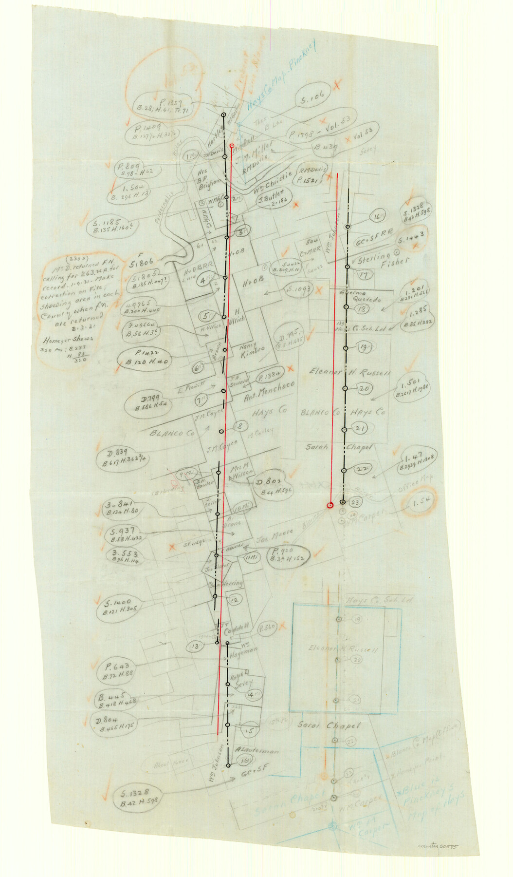
Blanco County Boundary File 8
Sketch of Blanco-Hays County Line
-
Map/Doc
50575
-
Collection
General Map Collection
-
Counties
Blanco
-
Subjects
County Boundaries
-
Height x Width
20.1 x 11.1 inches
51.1 x 28.2 cm
Part of: General Map Collection
Haskell County Sketch File 6

Print $22.00
- Digital $50.00
Haskell County Sketch File 6
1858
Size 7.7 x 12.2 inches
Map/Doc 26126
Flight Mission No. DAG-18K, Frame 72, Matagorda County

Print $20.00
- Digital $50.00
Flight Mission No. DAG-18K, Frame 72, Matagorda County
1952
Size 18.5 x 22.2 inches
Map/Doc 86365
Lamb County Sketch File C

Print $18.00
- Digital $50.00
Lamb County Sketch File C
1904
Size 10.2 x 8.4 inches
Map/Doc 29347
Nueces County Rolled Sketch 107

Print $56.00
Nueces County Rolled Sketch 107
1987
Size 18.4 x 24.8 inches
Map/Doc 7104
Polk County Working Sketch 19

Print $20.00
- Digital $50.00
Polk County Working Sketch 19
1950
Size 34.0 x 26.5 inches
Map/Doc 71634
Newton County Aerial Photograph Index Sheet 4

Print $20.00
- Digital $50.00
Newton County Aerial Photograph Index Sheet 4
1953
Size 23.8 x 16.5 inches
Map/Doc 83733
Brazos Santiago, Texas

Print $20.00
- Digital $50.00
Brazos Santiago, Texas
1882
Size 18.3 x 26.0 inches
Map/Doc 72986
Flight Mission No. DCL-7C, Frame 110, Kenedy County

Print $20.00
- Digital $50.00
Flight Mission No. DCL-7C, Frame 110, Kenedy County
1943
Size 18.5 x 22.3 inches
Map/Doc 86075
Bailey County Rolled Sketch 2

Print $20.00
- Digital $50.00
Bailey County Rolled Sketch 2
1913
Size 26.8 x 21.4 inches
Map/Doc 5109
Cooke County Sketch File 27

Print $24.00
- Digital $50.00
Cooke County Sketch File 27
Size 9.8 x 8.5 inches
Map/Doc 19279
[Surveys near Hondo Creek]
![226, [Surveys near Hondo Creek], General Map Collection](https://historictexasmaps.com/wmedia_w700/maps/226.tif.jpg)
Print $2.00
- Digital $50.00
[Surveys near Hondo Creek]
1847
Size 13.8 x 8.0 inches
Map/Doc 226
Index for Texas Railroad ROW & track maps available on microfilm at THD & Archives and Records

Print $2.00
- Digital $50.00
Index for Texas Railroad ROW & track maps available on microfilm at THD & Archives and Records
1977
Size 11.2 x 8.8 inches
Map/Doc 60757
You may also like
Pecos County Rolled Sketch 57

Print $20.00
- Digital $50.00
Pecos County Rolled Sketch 57
1917
Size 24.8 x 35.6 inches
Map/Doc 7230
East line Stonewall Co./West line Haskell Co.

Print $20.00
- Digital $50.00
East line Stonewall Co./West line Haskell Co.
1893
Size 7.5 x 39.1 inches
Map/Doc 91929
Hudspeth County Rolled Sketch 55

Print $49.00
- Digital $50.00
Hudspeth County Rolled Sketch 55
1977
Size 10.0 x 15.0 inches
Map/Doc 45968
Kimble County Working Sketch 34

Print $20.00
- Digital $50.00
Kimble County Working Sketch 34
1945
Size 34.4 x 26.7 inches
Map/Doc 70102
General Highway Map, San Augustine County, Texas

Print $20.00
General Highway Map, San Augustine County, Texas
1940
Size 24.8 x 18.3 inches
Map/Doc 79235
Dickens County Sketch File 21

Print $20.00
- Digital $50.00
Dickens County Sketch File 21
1911
Size 16.0 x 12.8 inches
Map/Doc 11324
[Tie Line, Zavala County School Land to North Line of Block D11, East and South to Double Lakes Corner]
![91868, [Tie Line, Zavala County School Land to North Line of Block D11, East and South to Double Lakes Corner], Twichell Survey Records](https://historictexasmaps.com/wmedia_w700/maps/91868-1.tif.jpg)
Print $20.00
- Digital $50.00
[Tie Line, Zavala County School Land to North Line of Block D11, East and South to Double Lakes Corner]
1900
Size 18.5 x 12.6 inches
Map/Doc 91868
Duval County Rolled Sketch HD

Print $20.00
- Digital $50.00
Duval County Rolled Sketch HD
1939
Size 22.8 x 32.8 inches
Map/Doc 5767
Flight Mission No. BQR-7K, Frame 30, Brazoria County

Print $20.00
- Digital $50.00
Flight Mission No. BQR-7K, Frame 30, Brazoria County
1952
Size 18.6 x 22.3 inches
Map/Doc 84028

Val Verde County Working Sketch 58

Print $20.00
- Digital $50.00
Val Verde County Working Sketch 58
1958
Size 21.0 x 22.8 inches
Map/Doc 72193
Official Map, City of Lubbock, Lubbock County, Texas

Print $20.00
- Digital $50.00
Official Map, City of Lubbock, Lubbock County, Texas
1927
Size 24.1 x 32.9 inches
Map/Doc 91329