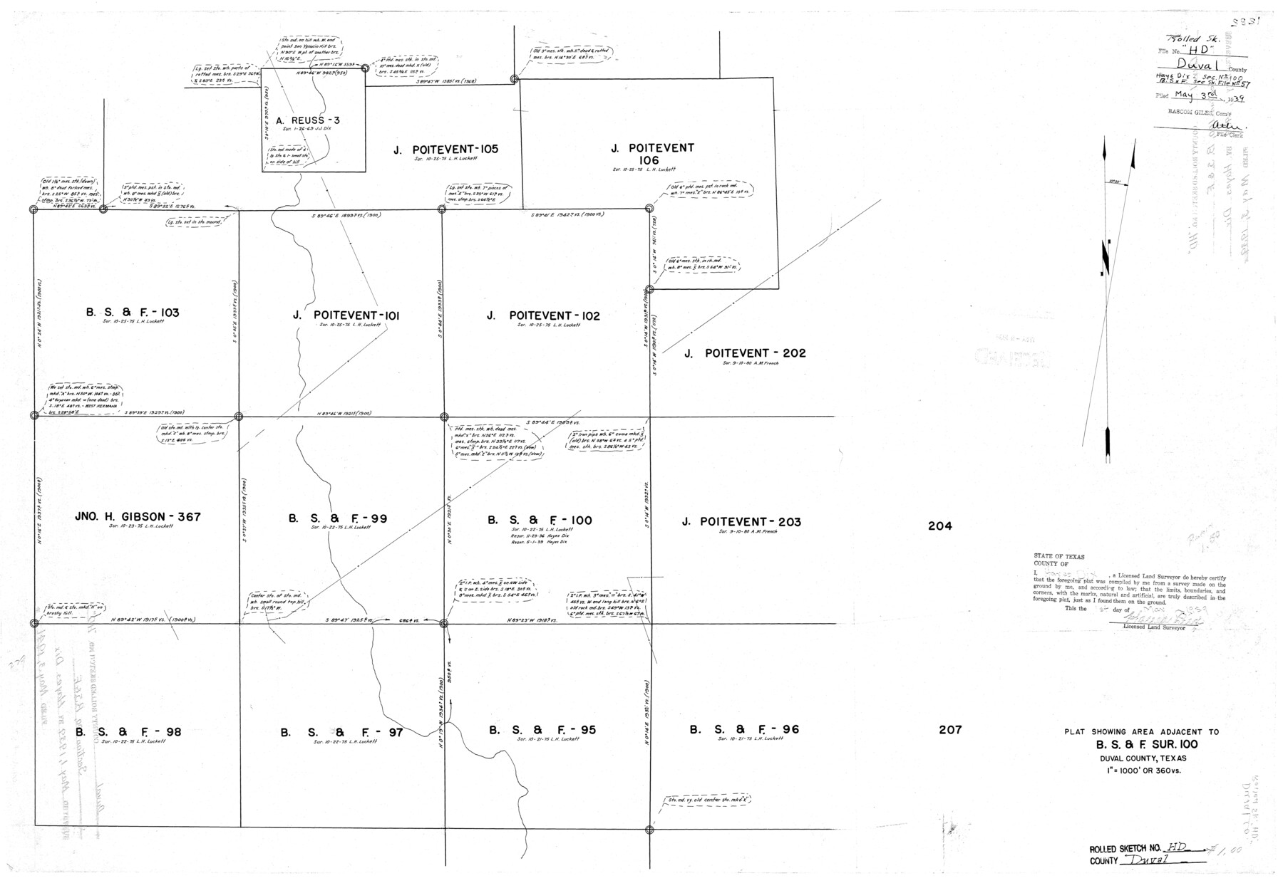
Duval County Rolled Sketch HD
Plat showing area adjacent to B. S. & F. sur. 100
-
Map/Doc
5767
-
Collection
General Map Collection
-
Object Dates
1939/5/1 (Creation Date)
1939/5/3 (File Date)
-
People and Organizations
Hayes Dix (Surveyor/Engineer)
-
Counties
Duval
-
Subjects
Surveying Rolled Sketch
-
Height x Width
22.8 x 32.8 inches
57.9 x 83.3 cm
-
Scale
1" = 360 varas
-
Comments
See Duval County Sketch File 57 (21418) for surveyor's explanation.
Related maps
Duval County Sketch File 57

Print $14.00
- Digital $50.00
Duval County Sketch File 57
1939
Size 14.2 x 8.9 inches
Map/Doc 21418
Part of: General Map Collection
Cameron County Working Sketch 2

Print $40.00
- Digital $50.00
Cameron County Working Sketch 2
1937
Size 43.1 x 51.7 inches
Map/Doc 67881
Leon County Rolled Sketch 27A

Print $40.00
- Digital $50.00
Leon County Rolled Sketch 27A
Size 50.5 x 47.8 inches
Map/Doc 9437
Travis County Appraisal District Plat Map 2_1804

Print $20.00
- Digital $50.00
Travis County Appraisal District Plat Map 2_1804
Size 21.6 x 26.5 inches
Map/Doc 94203
Tyler County Sketch File 19a

Print $4.00
- Digital $50.00
Tyler County Sketch File 19a
Size 8.1 x 14.1 inches
Map/Doc 38672
Map of Newton Co.

Print $20.00
- Digital $50.00
Map of Newton Co.
1918
Size 46.4 x 39.4 inches
Map/Doc 81987
Jackson County

Print $20.00
- Digital $50.00
Jackson County
1896
Size 24.8 x 21.0 inches
Map/Doc 3710
Val Verde County Rolled Sketch 75

Print $20.00
- Digital $50.00
Val Verde County Rolled Sketch 75
1972
Size 28.9 x 40.6 inches
Map/Doc 8138
Cameron County Sketch File 14

Print $38.00
- Digital $50.00
Cameron County Sketch File 14
1993
Size 11.2 x 8.8 inches
Map/Doc 17311
Bowie County Sketch File 1

Print $8.00
- Digital $50.00
Bowie County Sketch File 1
Size 8.6 x 10.0 inches
Map/Doc 14833
[Galveston, Harrisburg & San Antonio through El Paso County]
![64001, [Galveston, Harrisburg & San Antonio through El Paso County], General Map Collection](https://historictexasmaps.com/wmedia_w700/maps/64001.tif.jpg)
Print $20.00
- Digital $50.00
[Galveston, Harrisburg & San Antonio through El Paso County]
1907
Size 13.6 x 33.7 inches
Map/Doc 64001
Dimmit County Rolled Sketch M

Print $20.00
- Digital $50.00
Dimmit County Rolled Sketch M
1936
Size 21.5 x 39.3 inches
Map/Doc 5727
Bell County Sketch File 19

Print $4.00
- Digital $50.00
Bell County Sketch File 19
Size 7.6 x 7.7 inches
Map/Doc 14402
You may also like
Padre Island National Seashore

Print $4.00
- Digital $50.00
Padre Island National Seashore
Size 16.1 x 22.3 inches
Map/Doc 60535
Atascosa County Working Sketch 26

Print $20.00
- Digital $50.00
Atascosa County Working Sketch 26
1960
Size 46.9 x 43.7 inches
Map/Doc 67222
Flight Mission No. BRA-6M, Frame 147, Jefferson County

Print $20.00
- Digital $50.00
Flight Mission No. BRA-6M, Frame 147, Jefferson County
1953
Size 18.6 x 22.4 inches
Map/Doc 85448
[Blocks M-23, M-17, M-18, H, G, and vicinity]
![91141, [Blocks M-23, M-17, M-18, H, G, and vicinity], Twichell Survey Records](https://historictexasmaps.com/wmedia_w700/maps/91141-1.tif.jpg)
Print $20.00
- Digital $50.00
[Blocks M-23, M-17, M-18, H, G, and vicinity]
1882
Size 12.9 x 12.4 inches
Map/Doc 91141
Railroad Track Map, H&TCRRCo., Falls County, Texas

Print $4.00
- Digital $50.00
Railroad Track Map, H&TCRRCo., Falls County, Texas
1918
Size 11.7 x 18.7 inches
Map/Doc 62845
[Reynolds Cattle Company Lands]
![90680, [Reynolds Cattle Company Lands], Twichell Survey Records](https://historictexasmaps.com/wmedia_w700/maps/90680-1.tif.jpg)
Print $20.00
- Digital $50.00
[Reynolds Cattle Company Lands]
1908
Size 12.6 x 30.7 inches
Map/Doc 90680
Hutchinson County Rolled Sketch 10

Print $20.00
- Digital $50.00
Hutchinson County Rolled Sketch 10
Size 33.6 x 29.7 inches
Map/Doc 6281
Newton County Working Sketch 1

Print $20.00
- Digital $50.00
Newton County Working Sketch 1
Size 25.5 x 25.9 inches
Map/Doc 71247
Duval County Sketch File 51

Print $20.00
- Digital $50.00
Duval County Sketch File 51
Size 19.1 x 33.8 inches
Map/Doc 11401
El Paso County Rolled Sketch Z51

Print $40.00
- Digital $50.00
El Paso County Rolled Sketch Z51
1915
Size 37.2 x 49.0 inches
Map/Doc 8868
Reconnoissance of Sabine River and Vicinty

Print $20.00
Reconnoissance of Sabine River and Vicinty
1863
Size 30.4 x 42.3 inches
Map/Doc 97497
Lipscomb County Rolled Sketch 5

Print $40.00
- Digital $50.00
Lipscomb County Rolled Sketch 5
Size 9.8 x 62.5 inches
Map/Doc 10639