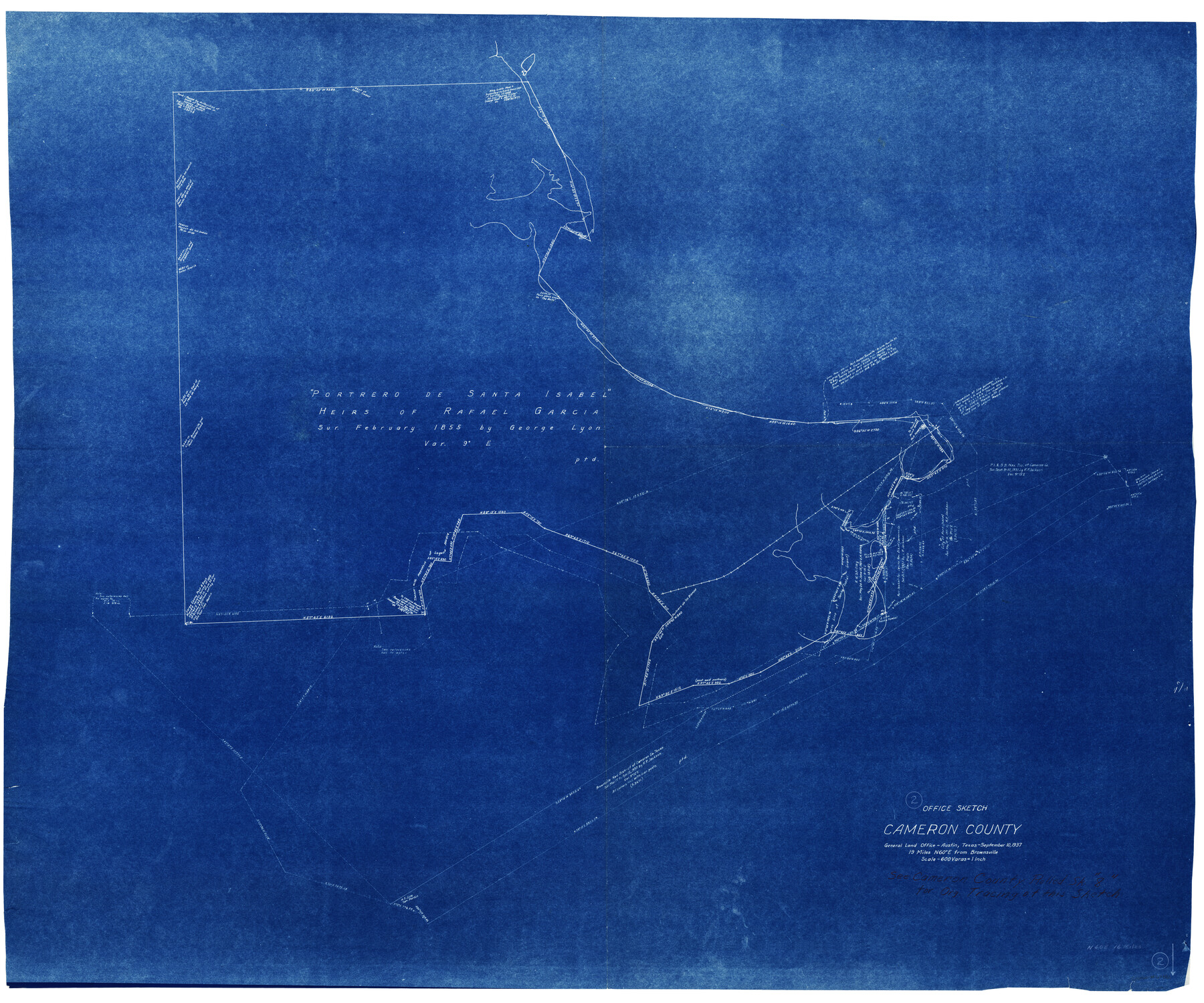
Cameron County Working Sketch 2
-
Map/Doc
67881
-
Collection
General Map Collection
-
Object Dates
9/10/1937 (Creation Date)
-
Counties
Cameron
-
Subjects
Surveying Working Sketch
-
Height x Width
43.1 x 51.7 inches
109.5 x 131.3 cm
-
Scale
1" = 600 varas
Part of: General Map Collection
Crockett County Rolled Sketch 89

Print $20.00
- Digital $50.00
Crockett County Rolled Sketch 89
1974
Size 21.1 x 15.8 inches
Map/Doc 5630
General Chart of the Coast No. XVI - Gulf Coast from Galveston to the Rio Grande

Print $20.00
- Digital $50.00
General Chart of the Coast No. XVI - Gulf Coast from Galveston to the Rio Grande
1883
Size 26.8 x 18.2 inches
Map/Doc 72736
Hamilton County Sketch File 23

Print $20.00
- Digital $50.00
Hamilton County Sketch File 23
1955
Size 25.8 x 24.8 inches
Map/Doc 11618
[The S.K. Ry. of Texas, State Line to Pecos, Reeves Co., Texas]
![64158, [The S.K. Ry. of Texas, State Line to Pecos, Reeves Co., Texas], General Map Collection](https://historictexasmaps.com/wmedia_w700/maps/64158.tif.jpg)
Print $40.00
- Digital $50.00
[The S.K. Ry. of Texas, State Line to Pecos, Reeves Co., Texas]
1910
Size 18.9 x 120.1 inches
Map/Doc 64158
Grayson County Boundary File 2

Print $14.00
- Digital $50.00
Grayson County Boundary File 2
Size 12.7 x 7.9 inches
Map/Doc 53931
Current Miscellaneous File 70

Print $10.00
- Digital $50.00
Current Miscellaneous File 70
Size 14.2 x 8.9 inches
Map/Doc 74150
Taylor County Working Sketch 17

Print $20.00
- Digital $50.00
Taylor County Working Sketch 17
1982
Size 42.7 x 37.0 inches
Map/Doc 69627
Robertson County Working Sketch 4

Print $20.00
- Digital $50.00
Robertson County Working Sketch 4
1979
Size 19.5 x 32.1 inches
Map/Doc 63577
Motley County Sketch File 5 (S)

Print $20.00
- Digital $50.00
Motley County Sketch File 5 (S)
Size 20.5 x 19.4 inches
Map/Doc 42138
Mitchell County Sketch File 7A

Print $20.00
- Digital $50.00
Mitchell County Sketch File 7A
1906
Size 20.4 x 14.0 inches
Map/Doc 12097
Flight Mission No. DQN-2K, Frame 86, Calhoun County

Print $20.00
- Digital $50.00
Flight Mission No. DQN-2K, Frame 86, Calhoun County
1953
Size 18.6 x 22.2 inches
Map/Doc 84276
Il Cuscho Citta Principale Della Provincia del Peru

Print $20.00
- Digital $50.00
Il Cuscho Citta Principale Della Provincia del Peru
1592
Size 12.3 x 15.4 inches
Map/Doc 97026
You may also like
Presidio County Rolled Sketch MS

Print $20.00
- Digital $50.00
Presidio County Rolled Sketch MS
Size 35.9 x 19.0 inches
Map/Doc 7412
Cooke County Sketch File 33

Print $44.00
- Digital $50.00
Cooke County Sketch File 33
1873
Size 13.4 x 26.5 inches
Map/Doc 11174
Flight Mission No. BRA-7M, Frame 124, Jefferson County

Print $20.00
- Digital $50.00
Flight Mission No. BRA-7M, Frame 124, Jefferson County
1953
Size 16.2 x 16.1 inches
Map/Doc 85518
Grayson County

Print $20.00
- Digital $50.00
Grayson County
1935
Size 43.4 x 40.5 inches
Map/Doc 95512
Burnet County Working Sketch 8

Print $20.00
- Digital $50.00
Burnet County Working Sketch 8
1973
Size 27.2 x 28.0 inches
Map/Doc 67851
Chart of the Antarctic Continent shewing the icy barrier attached to it discovered by the U.S. Ex. Ex.

Print $20.00
- Digital $50.00
Chart of the Antarctic Continent shewing the icy barrier attached to it discovered by the U.S. Ex. Ex.
1840
Size 26.5 x 37.2 inches
Map/Doc 94058
Concho County Sketch File 39

Print $8.00
- Digital $50.00
Concho County Sketch File 39
1949
Size 11.3 x 8.8 inches
Map/Doc 19190
Flight Mission No. DAG-26K, Frame 60, Matagorda County

Print $20.00
- Digital $50.00
Flight Mission No. DAG-26K, Frame 60, Matagorda County
1953
Size 18.7 x 22.7 inches
Map/Doc 86580

Starr County Sketch File 9

Print $22.00
- Digital $50.00
Starr County Sketch File 9
Size 9.1 x 7.9 inches
Map/Doc 36861
Webb County Boundary File 3

Print $74.00
- Digital $50.00
Webb County Boundary File 3
Size 11.3 x 8.8 inches
Map/Doc 59716
From Citizens Living in What Was to Become Fannin County for the Creation of a New County (Unnamed), Undated

Print $20.00
From Citizens Living in What Was to Become Fannin County for the Creation of a New County (Unnamed), Undated
2020
Size 17.6 x 21.7 inches
Map/Doc 96400