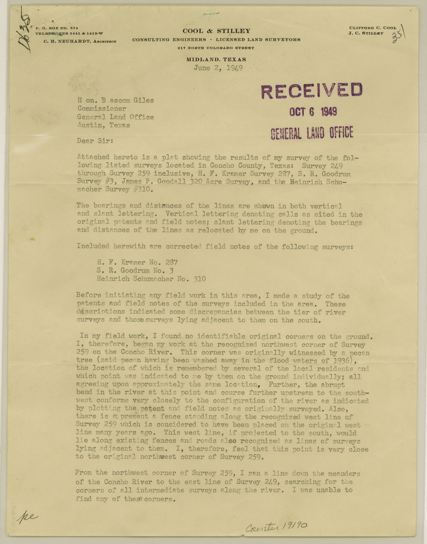
Concho County Sketch File 39
[Report of a re-survey of river surveys 249 through 259 and adjoining surveys]
-
Map/Doc
19190
-
Collection
General Map Collection
-
Object Dates
1949/6/2 (Creation Date)
1949/10/19 (File Date)
1949/5/4 (Survey Date)
-
People and Organizations
Clifford C. Cool (Surveyor/Engineer)
-
Counties
Concho
-
Subjects
Surveying Sketch File
-
Height x Width
11.3 x 8.8 inches
28.7 x 22.4 cm
-
Medium
paper, print
-
Comments
See Concho County Rolled Sketch 3 (8648) for sketch.
-
Features
Concho River
Related maps
Concho County Rolled Sketch 3

Print $40.00
- Digital $50.00
Concho County Rolled Sketch 3
1949
Size 67.0 x 46.0 inches
Map/Doc 8648
Part of: General Map Collection
Real County Working Sketch 72

Print $20.00
- Digital $50.00
Real County Working Sketch 72
1976
Size 47.3 x 43.3 inches
Map/Doc 71964
Webb County Rolled Sketch 4

Print $20.00
- Digital $50.00
Webb County Rolled Sketch 4
Size 32.8 x 26.3 inches
Map/Doc 8171
Flight Mission No. BRA-7M, Frame 131, Jefferson County

Print $20.00
- Digital $50.00
Flight Mission No. BRA-7M, Frame 131, Jefferson County
1953
Size 16.2 x 16.0 inches
Map/Doc 85525
Medina County Working Sketch 3

Print $40.00
- Digital $50.00
Medina County Working Sketch 3
1945
Size 52.6 x 37.1 inches
Map/Doc 70918
Borden County Rolled Sketch 11

Print $20.00
- Digital $50.00
Borden County Rolled Sketch 11
1963
Size 33.2 x 32.2 inches
Map/Doc 8450
Loving County Sketch File 3

Print $6.00
- Digital $50.00
Loving County Sketch File 3
1952
Size 11.2 x 8.7 inches
Map/Doc 30409
Fort Bend County Sketch File 7

Print $4.00
- Digital $50.00
Fort Bend County Sketch File 7
1876
Size 12.9 x 8.0 inches
Map/Doc 22892
Nueces County Sketch File 72

Print $13.00
- Digital $50.00
Nueces County Sketch File 72
1991
Size 11.1 x 8.8 inches
Map/Doc 33020
Flight Mission No. BRA-16M, Frame 104, Jefferson County

Print $20.00
- Digital $50.00
Flight Mission No. BRA-16M, Frame 104, Jefferson County
1953
Size 18.5 x 22.3 inches
Map/Doc 85716
East Part of Jeff Davis Co.

Print $20.00
- Digital $50.00
East Part of Jeff Davis Co.
1977
Size 46.4 x 35.7 inches
Map/Doc 73194
Collingsworth County

Print $20.00
- Digital $50.00
Collingsworth County
1892
Size 26.5 x 20.8 inches
Map/Doc 66759
Marion County Rolled Sketch 1A

Print $15.00
- Digital $50.00
Marion County Rolled Sketch 1A
1954
Size 9.9 x 15.2 inches
Map/Doc 46610
You may also like

Van Zandt County Sketch File 8

Print $10.00
- Digital $50.00
Van Zandt County Sketch File 8
1851
Size 9.7 x 7.9 inches
Map/Doc 39379
Shackelford County Sketch File 12

Print $26.00
- Digital $50.00
Shackelford County Sketch File 12
1949
Size 14.4 x 8.8 inches
Map/Doc 36580
Fort Bend County Sketch File 31

Print $10.00
- Digital $50.00
Fort Bend County Sketch File 31
1940
Size 13.3 x 8.7 inches
Map/Doc 22997
El Paso County Boundary File 20

Print $9.00
- Digital $50.00
El Paso County Boundary File 20
Size 13.2 x 8.3 inches
Map/Doc 53210

Trinity River, Irving Sheet

Print $4.00
- Digital $50.00
Trinity River, Irving Sheet
1925
Size 20.7 x 17.9 inches
Map/Doc 65212
Brewster County Rolled Sketch 27

Print $40.00
- Digital $50.00
Brewster County Rolled Sketch 27
Size 35.1 x 48.8 inches
Map/Doc 8474
Gregg County Working Sketch 2

Print $20.00
- Digital $50.00
Gregg County Working Sketch 2
1931
Size 16.8 x 13.6 inches
Map/Doc 63268
Travis County Sketch File 74

Print $10.00
- Digital $50.00
Travis County Sketch File 74
1992
Size 11.5 x 8.8 inches
Map/Doc 38468
Carta Particular de la Parte sur del Seno Mexicano que comprehende las Cóstas de Yucatan y Sonda de Campeche, las de Tabasco, Veracruz y Tamaulipas

Carta Particular de la Parte sur del Seno Mexicano que comprehende las Cóstas de Yucatan y Sonda de Campeche, las de Tabasco, Veracruz y Tamaulipas
1825
Size 26.6 x 38.5 inches
Map/Doc 94567
Sabine River, Iron Bridge Crossing Sheet

Print $20.00
- Digital $50.00
Sabine River, Iron Bridge Crossing Sheet
1936
Size 33.0 x 40.6 inches
Map/Doc 65139