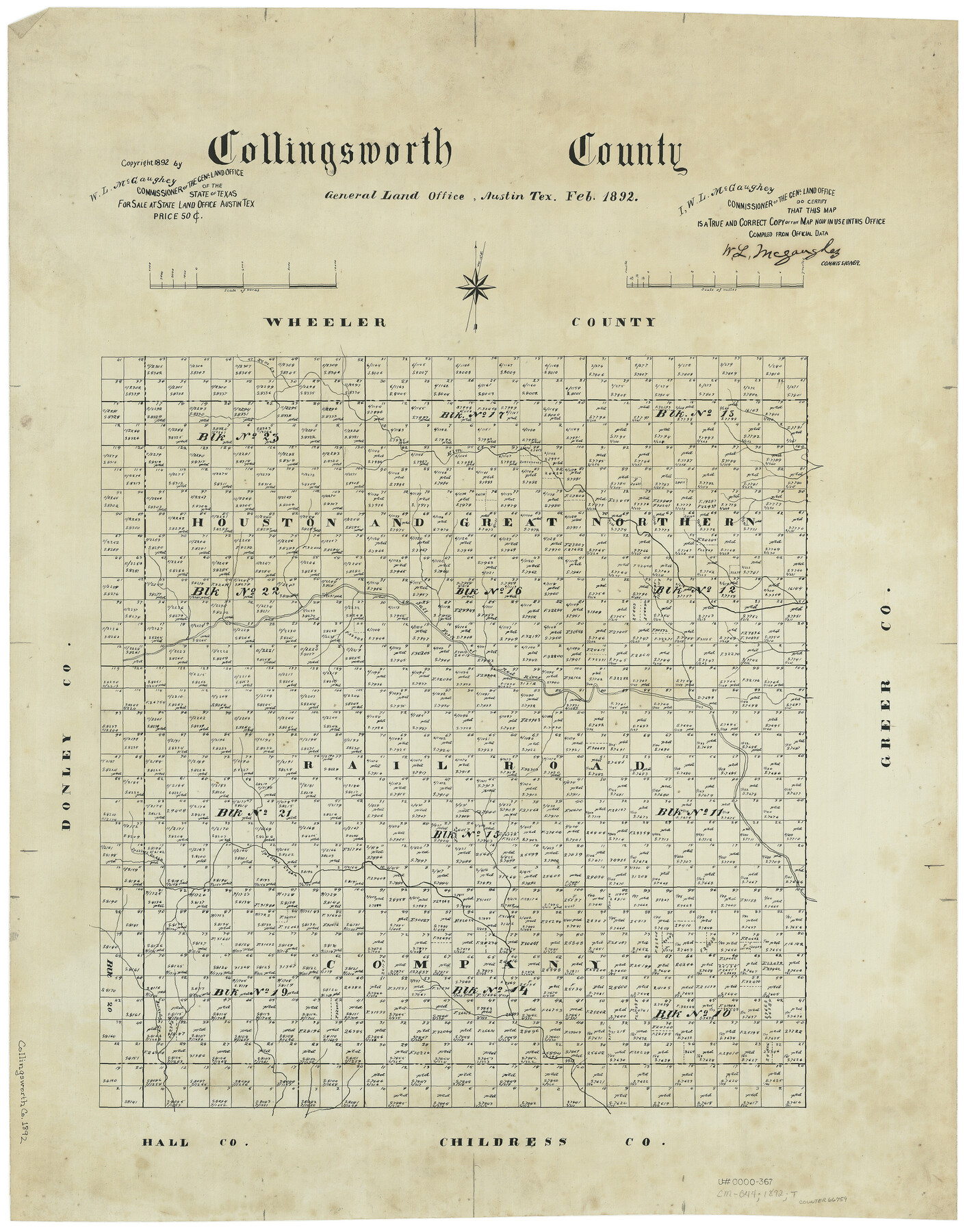
Collingsworth County
-
Map/Doc
66759
-
Collection
General Map Collection
-
Object Dates
2/1892 (Creation Date)
-
People and Organizations
Texas General Land Office (Publisher)
W.L. McGaughey (GLO Commissioner)
-
Counties
Collingsworth
-
Subjects
County
-
Height x Width
26.5 x 20.8 inches
67.3 x 52.8 cm
-
Comments
Copyrighted 1892.
Part of: General Map Collection
Pecos County Sketch File 37

Print $4.00
- Digital $50.00
Pecos County Sketch File 37
1911
Size 8.9 x 8.3 inches
Map/Doc 33718
Flight Mission No. BRA-6M, Frame 90, Jefferson County

Print $20.00
- Digital $50.00
Flight Mission No. BRA-6M, Frame 90, Jefferson County
1953
Size 18.5 x 22.2 inches
Map/Doc 85433
Flight Mission No. DQN-1K, Frame 81, Calhoun County

Print $20.00
- Digital $50.00
Flight Mission No. DQN-1K, Frame 81, Calhoun County
1953
Size 18.4 x 22.1 inches
Map/Doc 84166
Smith County Rolled Sketch 2

Print $20.00
- Digital $50.00
Smith County Rolled Sketch 2
Size 36.2 x 34.6 inches
Map/Doc 76010
Chambers County Sketch File B

Print $2.00
- Digital $50.00
Chambers County Sketch File B
1907
Size 7.2 x 8.5 inches
Map/Doc 17515
Comanche County Sketch File 24 1/2

Print $6.00
- Digital $50.00
Comanche County Sketch File 24 1/2
Size 10.5 x 15.8 inches
Map/Doc 19113
Cooke County Working Sketch 2

Print $20.00
- Digital $50.00
Cooke County Working Sketch 2
1925
Size 22.2 x 10.9 inches
Map/Doc 68239
Morris County Rolled Sketch 2A

Print $20.00
- Digital $50.00
Morris County Rolled Sketch 2A
Size 24.3 x 19.2 inches
Map/Doc 10251
Ashburn's 1951 Austin City Map

Ashburn's 1951 Austin City Map
1951
Size 22.5 x 17.4 inches
Map/Doc 97142

Matagorda County Working Sketch 10

Print $20.00
- Digital $50.00
Matagorda County Working Sketch 10
1958
Size 27.8 x 33.3 inches
Map/Doc 70868
Duval County Sketch File 78

Print $2.00
- Digital $50.00
Duval County Sketch File 78
1984
Size 14.5 x 8.9 inches
Map/Doc 21468
You may also like
Flight Mission No. DAH-10M, Frame 44, Orange County

Print $20.00
- Digital $50.00
Flight Mission No. DAH-10M, Frame 44, Orange County
1953
Size 18.6 x 22.4 inches
Map/Doc 86879
Brewster County Rolled Sketch 146B

Print $40.00
- Digital $50.00
Brewster County Rolled Sketch 146B
1985
Size 55.5 x 45.2 inches
Map/Doc 8528
Sterling County Rolled Sketch 25

Print $20.00
- Digital $50.00
Sterling County Rolled Sketch 25
Size 31.4 x 35.3 inches
Map/Doc 9955
Frio County Working Sketch 5

Print $20.00
- Digital $50.00
Frio County Working Sketch 5
1936
Size 33.9 x 23.0 inches
Map/Doc 69279
Donley County Sketch File B7

Print $20.00
- Digital $50.00
Donley County Sketch File B7
1919
Size 25.5 x 32.4 inches
Map/Doc 11377
Brazoria County NRC Article 33.136 Sketch 11

Print $24.00
- Digital $50.00
Brazoria County NRC Article 33.136 Sketch 11
2012
Size 24.0 x 18.0 inches
Map/Doc 94777
Presidio County Sketch File 85

Print $6.00
- Digital $50.00
Presidio County Sketch File 85
1950
Size 14.3 x 8.9 inches
Map/Doc 34745
Cherokee County Sketch File 33

Print $16.00
- Digital $50.00
Cherokee County Sketch File 33
1935
Size 11.5 x 7.2 inches
Map/Doc 18190
[Sketch Showing Loma Blanca and San Antonio de Encinal Leagues, Brooks County, Texas]
![4448, [Sketch Showing Loma Blanca and San Antonio de Encinal Leagues, Brooks County, Texas], Maddox Collection](https://historictexasmaps.com/wmedia_w700/maps/4448-1.tif.jpg)
Print $3.00
- Digital $50.00
[Sketch Showing Loma Blanca and San Antonio de Encinal Leagues, Brooks County, Texas]
1912
Size 15.1 x 11.4 inches
Map/Doc 4448
Gray County Working Sketch 5

Print $20.00
- Digital $50.00
Gray County Working Sketch 5
1959
Size 28.6 x 27.5 inches
Map/Doc 63236
Map of Kendall County

Print $20.00
- Digital $50.00
Map of Kendall County
1879
Size 20.4 x 20.8 inches
Map/Doc 3752
Freestone County Sketch File 7

Print $4.00
- Digital $50.00
Freestone County Sketch File 7
1861
Size 14.4 x 8.3 inches
Map/Doc 23052