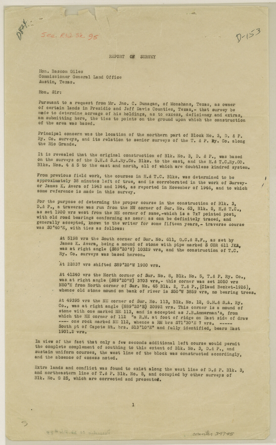
Presidio County Sketch File 85
[Report in northwest part of county]
-
Map/Doc
34745
-
Collection
General Map Collection
-
Object Dates
1/21/1950 (Creation Date)
1/21/1950 (File Date)
1943 (Survey Date)
1944 (Survey Date)
11/1946 (Survey Date)
1926 (Survey Date)
-
People and Organizations
W.F. Sowell (Surveyor/Engineer)
James K. Avera (Surveyor/Engineer)
Claud Becket (Surveyor/Engineer)
J.B. Ammerman (Surveyor/Engineer)
-
Counties
Presidio Jeff Davis
-
Subjects
Surveying Sketch File
-
Height x Width
14.3 x 8.9 inches
36.3 x 22.6 cm
-
Medium
paper, print
-
Comments
See Presidio County Rolled Sketch 95 (9781) for sketch.
-
Features
Rio Grande
Capote Mountain
Related maps
Presidio County Rolled Sketch 95

Print $20.00
- Digital $50.00
Presidio County Rolled Sketch 95
1949
Size 45.4 x 37.5 inches
Map/Doc 9781
Part of: General Map Collection
Motley County Sketch File 30 (S)

Print $40.00
- Digital $50.00
Motley County Sketch File 30 (S)
1905
Size 16.1 x 17.1 inches
Map/Doc 42147
Flight Mission No. DIX-7P, Frame 15, Aransas County

Print $20.00
- Digital $50.00
Flight Mission No. DIX-7P, Frame 15, Aransas County
1956
Size 18.8 x 22.8 inches
Map/Doc 83867
Jefferson County Rolled Sketch 20

Print $60.00
- Digital $50.00
Jefferson County Rolled Sketch 20
1935
Size 29.2 x 36.2 inches
Map/Doc 9285
Harris County Sketch File 69a

Print $20.00
- Digital $50.00
Harris County Sketch File 69a
1938
Size 19.4 x 21.3 inches
Map/Doc 11663
Midland County

Print $20.00
- Digital $50.00
Midland County
1930
Size 39.8 x 33.1 inches
Map/Doc 77372
Angelina County Working Sketch 52

Print $20.00
- Digital $50.00
Angelina County Working Sketch 52
1978
Size 20.8 x 20.3 inches
Map/Doc 67136
Gillespie County Sketch File 2

Print $40.00
- Digital $50.00
Gillespie County Sketch File 2
1847
Size 12.8 x 15.5 inches
Map/Doc 24127
Matagorda County Sketch File 13

Print $20.00
- Digital $50.00
Matagorda County Sketch File 13
1902
Size 21.5 x 19.0 inches
Map/Doc 12039
Live Oak County Sketch File 11b

Print $6.00
- Digital $50.00
Live Oak County Sketch File 11b
Size 8.2 x 12.6 inches
Map/Doc 30267
Flight Mission No. DQO-1K, Frame 114, Galveston County

Print $20.00
- Digital $50.00
Flight Mission No. DQO-1K, Frame 114, Galveston County
1952
Size 18.8 x 22.5 inches
Map/Doc 84992
Packery Channel

Print $3.00
- Digital $50.00
Packery Channel
1962
Size 10.7 x 13.2 inches
Map/Doc 3005
Webb County Rolled Sketch 28

Print $20.00
- Digital $50.00
Webb County Rolled Sketch 28
1932
Size 27.5 x 20.6 inches
Map/Doc 8186
You may also like
Moore County Rolled Sketch 9

Print $20.00
- Digital $50.00
Moore County Rolled Sketch 9
1911
Size 24.9 x 18.2 inches
Map/Doc 6827
Flight Mission No. DQO-6K, Frame 22, Galveston County

Print $20.00
- Digital $50.00
Flight Mission No. DQO-6K, Frame 22, Galveston County
1952
Size 18.8 x 22.4 inches
Map/Doc 85095
Jefferson County Sketch File 48

Print $20.00
- Digital $50.00
Jefferson County Sketch File 48
1875
Size 19.8 x 21.0 inches
Map/Doc 11882
Zavala County Sketch File 39

Print $4.00
- Digital $50.00
Zavala County Sketch File 39
1884
Size 14.4 x 8.7 inches
Map/Doc 41404
Erath County Working Sketch 24

Print $20.00
- Digital $50.00
Erath County Working Sketch 24
1967
Size 41.5 x 39.3 inches
Map/Doc 69105
Tom Green County Boundary File 6

Print $42.00
- Digital $50.00
Tom Green County Boundary File 6
Size 14.5 x 9.0 inches
Map/Doc 59376
Live Oak County Working Sketch 13

Print $20.00
- Digital $50.00
Live Oak County Working Sketch 13
1957
Size 42.1 x 38.7 inches
Map/Doc 70598
Map of Taylor, Bastrop & Houston Railway through Colorado County, Texas

Print $20.00
- Digital $50.00
Map of Taylor, Bastrop & Houston Railway through Colorado County, Texas
1888
Size 12.7 x 20.0 inches
Map/Doc 64289
Harris County Working Sketch 59

Print $20.00
- Digital $50.00
Harris County Working Sketch 59
1953
Size 36.9 x 24.8 inches
Map/Doc 65951
Connected Map of Austin's Colony (1892 tracing)

Print $40.00
- Digital $50.00
Connected Map of Austin's Colony (1892 tracing)
1837
Size 90.8 x 46.7 inches
Map/Doc 93358
Throckmorton County

Print $20.00
- Digital $50.00
Throckmorton County
1943
Size 47.8 x 38.2 inches
Map/Doc 63065
Stonewall County Rolled Sketch 24B

Print $40.00
- Digital $50.00
Stonewall County Rolled Sketch 24B
1954
Size 50.1 x 43.1 inches
Map/Doc 9964