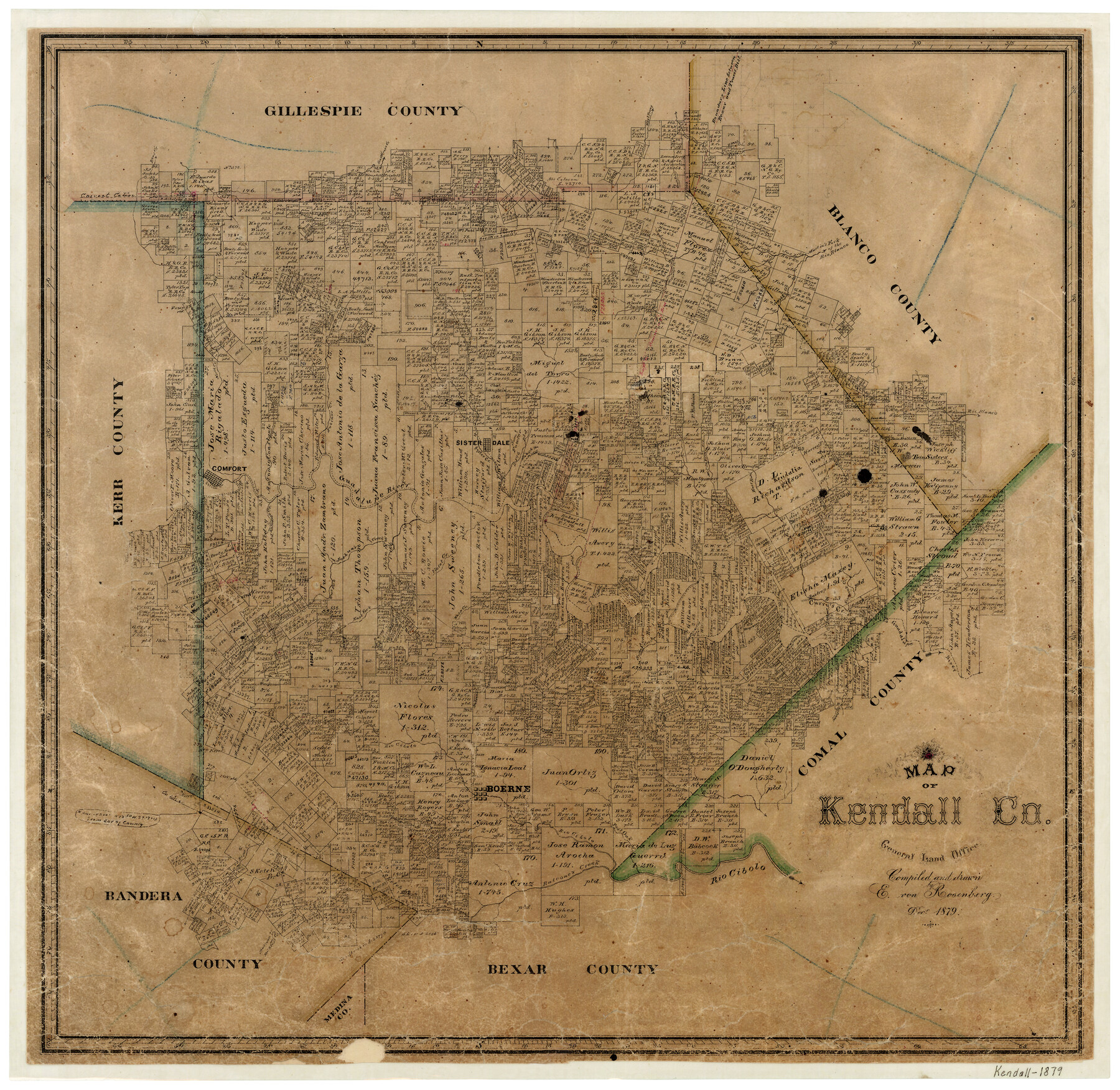
Map of Kendall County
-
Map/Doc
3752
-
Collection
General Map Collection
-
Object Dates
12/1879 (Creation Date)
-
People and Organizations
Texas General Land Office (Publisher)
E. von Rosenberg (Draftsman)
E. von Rosenberg (Compiler)
-
Counties
Kendall
-
Subjects
County
-
Height x Width
20.4 x 20.8 inches
51.8 x 52.8 cm
-
Features
Boerne
Twin Brothers
West Fork of Joshua's Creek
Violet Creek
East Fork of Joshua's Creek
Wasp Creek
Spring Creek
Curry's Creek
Simmon's Creek
Swede's Creek
Post Oak Creek
Rio Cibolo
Joshua's Creek
Freidrich Creek
Pipe Creek
Boar Creek
Madrones Creek
Real Bluff Creek
Balcones Creek
Honey Creek
East Prong [of Curry's Creek]
Oyster Creek
East Fork [of Guadalupe River]
Middle Prong [of Curry's Creek]
Grape Creek Sandbar
Grape Creek
South Grape Creek
South Prong
Martin's Fork of the Rio Blanco
Webb Creek
Rio Blanco
Twin Sisters
Kendalia
East Prong
Bear Creek
West Prong
Sisterdale
Syster Creek
Guadalupe River
Sabinas Creek
Holliday's Creek
Comfort
Cypress Creek
Flatrock Creek
North Creek
Part of: General Map Collection
Austin County

Print $20.00
- Digital $50.00
Austin County
1943
Size 38.5 x 41.3 inches
Map/Doc 77205
Jeff Davis County Sketch File 20

Print $56.00
- Digital $50.00
Jeff Davis County Sketch File 20
1923
Size 11.2 x 8.8 inches
Map/Doc 27978
Flight Mission No. CRC-4R, Frame 186, Chambers County

Print $20.00
- Digital $50.00
Flight Mission No. CRC-4R, Frame 186, Chambers County
1956
Size 18.6 x 22.3 inches
Map/Doc 84937
Val Verde County Working Sketch 56

Print $20.00
- Digital $50.00
Val Verde County Working Sketch 56
1957
Size 41.8 x 32.2 inches
Map/Doc 72191
Map of Texas Showing County Names Only

Print $20.00
- Digital $50.00
Map of Texas Showing County Names Only
Size 34.2 x 43.6 inches
Map/Doc 2163
Montgomery County Working Sketch 24

Print $40.00
- Digital $50.00
Montgomery County Working Sketch 24
1941
Size 35.8 x 52.5 inches
Map/Doc 71131
Wichita County Rolled Sketch 15

Print $20.00
- Digital $50.00
Wichita County Rolled Sketch 15
Size 17.0 x 37.1 inches
Map/Doc 8252
Flight Mission No. CUG-3P, Frame 93, Kleberg County

Print $20.00
- Digital $50.00
Flight Mission No. CUG-3P, Frame 93, Kleberg County
1956
Size 18.5 x 22.2 inches
Map/Doc 86263
Flight Mission No. DQN-2K, Frame 95, Calhoun County

Print $20.00
- Digital $50.00
Flight Mission No. DQN-2K, Frame 95, Calhoun County
1953
Size 18.6 x 22.3 inches
Map/Doc 84285
Harrison County Working Sketch 8

Print $20.00
- Digital $50.00
Harrison County Working Sketch 8
1956
Size 20.6 x 30.5 inches
Map/Doc 66028
Edwards County Working Sketch 33

Print $40.00
- Digital $50.00
Edwards County Working Sketch 33
1947
Size 42.6 x 50.2 inches
Map/Doc 68909
Rusk County Sketch File 31

Print $10.00
Rusk County Sketch File 31
1949
Size 11.3 x 8.9 inches
Map/Doc 35563
You may also like
[Map Showing Location and Right of Way of Proposed Groins]
![73623, [Map Showing Location and Right of Way of Proposed Groins], General Map Collection](https://historictexasmaps.com/wmedia_w700/maps/73623-1.tif.jpg)
Print $4.00
- Digital $50.00
[Map Showing Location and Right of Way of Proposed Groins]
Size 13.4 x 24.4 inches
Map/Doc 73623
[County table portion of 1879 State of Texas map by Pressler & Langermann]
![3102, [County table portion of 1879 State of Texas map by Pressler & Langermann], General Map Collection](https://historictexasmaps.com/wmedia_w700/maps/3102-1.tif.jpg)
Print $20.00
- Digital $50.00
[County table portion of 1879 State of Texas map by Pressler & Langermann]
1879
Size 15.0 x 23.6 inches
Map/Doc 3102
Fort Bend County Sketch File 27

Print $20.00
- Digital $50.00
Fort Bend County Sketch File 27
1910
Size 17.9 x 37.7 inches
Map/Doc 10453
[T.& P. RR Co. Block 32 Township 4 North]
![92455, [T.& P. RR Co. Block 32 Township 4 North], Twichell Survey Records](https://historictexasmaps.com/wmedia_w700/maps/92455-1.tif.jpg)
Print $20.00
- Digital $50.00
[T.& P. RR Co. Block 32 Township 4 North]
Size 35.5 x 19.5 inches
Map/Doc 92455
Flight Mission No. BRE-2P, Frame 135, Nueces County

Print $20.00
- Digital $50.00
Flight Mission No. BRE-2P, Frame 135, Nueces County
1956
Size 18.5 x 22.7 inches
Map/Doc 86808
Grayson County Sketch File 21

Print $14.00
- Digital $50.00
Grayson County Sketch File 21
Size 7.7 x 17.8 inches
Map/Doc 24495
Sectional Map No. 2 of the lands and the line of the Texas & Pacific Ry. Co. in Howard, Martin, Andrews, Midland and Tom Green Counties

Print $20.00
- Digital $50.00
Sectional Map No. 2 of the lands and the line of the Texas & Pacific Ry. Co. in Howard, Martin, Andrews, Midland and Tom Green Counties
1885
Size 18.9 x 23.2 inches
Map/Doc 4861
Hutchinson County Rolled Sketch 22

Print $20.00
- Digital $50.00
Hutchinson County Rolled Sketch 22
1914
Size 29.3 x 38.0 inches
Map/Doc 6287
Gaines County Working Sketch 13

Print $20.00
- Digital $50.00
Gaines County Working Sketch 13
1954
Size 36.8 x 39.4 inches
Map/Doc 69313
Comanche County Sketch File 3

Print $40.00
- Digital $50.00
Comanche County Sketch File 3
1847
Size 14.8 x 15.6 inches
Map/Doc 19055
[Travis Station Map - Tracks and Structures - Lands. San Antonio & Aransas Pass Railway Co.]
![62564, [Travis Station Map - Tracks and Structures - Lands. San Antonio & Aransas Pass Railway Co.], General Map Collection](https://historictexasmaps.com/wmedia_w700/maps/62564.tif.jpg)
Print $4.00
- Digital $50.00
[Travis Station Map - Tracks and Structures - Lands. San Antonio & Aransas Pass Railway Co.]
1919
Size 11.7 x 18.7 inches
Map/Doc 62564
Montgomery County Working Sketch 57

Print $20.00
- Digital $50.00
Montgomery County Working Sketch 57
1961
Size 24.2 x 26.6 inches
Map/Doc 71164