Shackelford County Sketch File 12
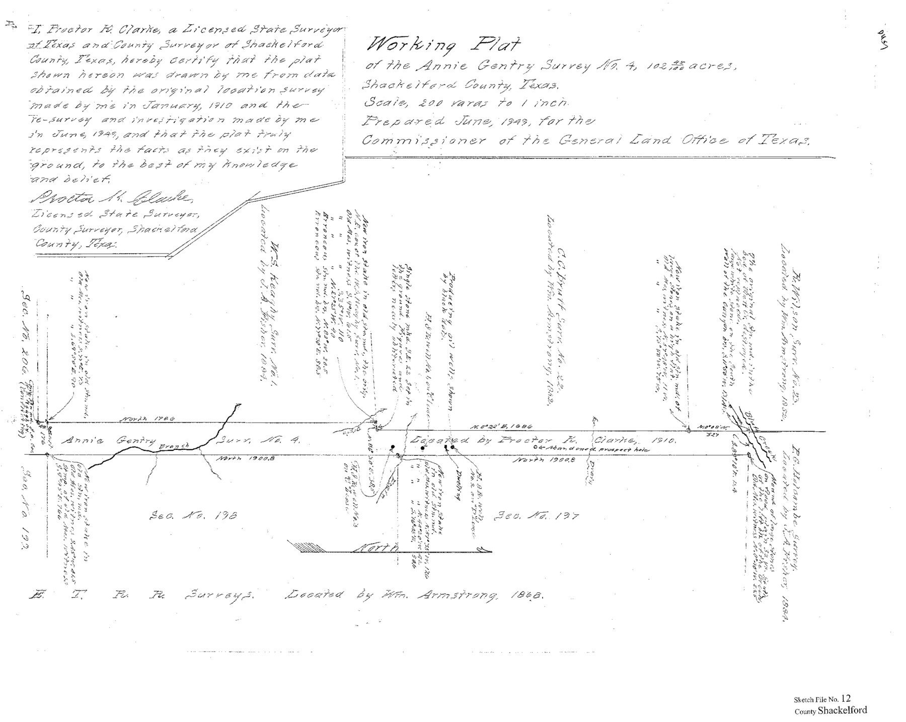
[Sketch and surveyor's report regarding a re-survey of the Annie Gentry survey no. 4 in the western part of the county]
-
Map/Doc
36580
-
Collection
General Map Collection
-
Object Dates
6/11/1949 (Creation Date)
6/15/1949 (File Date)
-
People and Organizations
Proctor K. Clarke (Surveyor/Engineer)
-
Counties
Shackelford
-
Subjects
Surveying Sketch File
-
Height x Width
14.4 x 8.8 inches
36.6 x 22.4 cm
-
Medium
multi-page, multi-format
-
Scale
1" = 200 varas
-
Features
Bluff Creek
Part of: General Map Collection
Reagan County Sketch File RB

Print $8.00
- Digital $50.00
Reagan County Sketch File RB
Size 11.3 x 9.0 inches
Map/Doc 34996
Mills County Boundary File 1a

Print $60.00
- Digital $50.00
Mills County Boundary File 1a
Size 9.7 x 31.6 inches
Map/Doc 57273
Flight Mission No. CUG-3P, Frame 161, Kleberg County

Print $20.00
- Digital $50.00
Flight Mission No. CUG-3P, Frame 161, Kleberg County
1956
Size 18.6 x 22.5 inches
Map/Doc 86281
Angelina County Sketch File 15

Print $8.00
- Digital $50.00
Angelina County Sketch File 15
1848
Size 12.5 x 7.5 inches
Map/Doc 12960
Cameron County Rolled Sketch 19

Print $20.00
- Digital $50.00
Cameron County Rolled Sketch 19
Size 25.8 x 23.6 inches
Map/Doc 5465
Val Verde County Working Sketch 49

Print $20.00
- Digital $50.00
Val Verde County Working Sketch 49
1949
Size 26.7 x 41.9 inches
Map/Doc 72184
[Sketch for Mineral Application 1112 - Colorado River, H. E. Chambers]
![65636, [Sketch for Mineral Application 1112 - Colorado River, H. E. Chambers], General Map Collection](https://historictexasmaps.com/wmedia_w700/maps/65636.tif.jpg)
Print $40.00
- Digital $50.00
[Sketch for Mineral Application 1112 - Colorado River, H. E. Chambers]
1918
Size 48.2 x 26.5 inches
Map/Doc 65636
Atascosa County Sketch File 1

Print $8.00
- Digital $50.00
Atascosa County Sketch File 1
Size 8.1 x 6.1 inches
Map/Doc 13718
Rusk County Rolled Sketch 11

Print $20.00
- Digital $50.00
Rusk County Rolled Sketch 11
1956
Size 33.2 x 43.3 inches
Map/Doc 9877
Hidalgo County Rolled Sketch 17

Print $40.00
- Digital $50.00
Hidalgo County Rolled Sketch 17
1963
Size 68.4 x 42.9 inches
Map/Doc 9172
Taylor County Rolled Sketch 27

Print $20.00
- Digital $50.00
Taylor County Rolled Sketch 27
Size 37.5 x 30.3 inches
Map/Doc 7918
Flight Mission No. DQO-2K, Frame 97, Galveston County

Print $20.00
- Digital $50.00
Flight Mission No. DQO-2K, Frame 97, Galveston County
1952
Size 18.7 x 22.5 inches
Map/Doc 85024
You may also like
Hood County Working Sketch 12

Print $40.00
- Digital $50.00
Hood County Working Sketch 12
1978
Size 25.2 x 55.5 inches
Map/Doc 66206
Refugio County Sketch File 7

Print $4.00
- Digital $50.00
Refugio County Sketch File 7
1875
Size 12.1 x 7.6 inches
Map/Doc 35251
Collingsworth County Rolled Sketch 1

Print $40.00
- Digital $50.00
Collingsworth County Rolled Sketch 1
1941
Size 58.0 x 27.0 inches
Map/Doc 8637
Ward County Working Sketch 40

Print $20.00
- Digital $50.00
Ward County Working Sketch 40
1969
Size 24.4 x 45.7 inches
Map/Doc 72346
Taylor County Sketch File 13

Print $8.00
- Digital $50.00
Taylor County Sketch File 13
1913
Size 9.1 x 8.5 inches
Map/Doc 37798
Nacogdoches County Working Sketch 2

Print $20.00
- Digital $50.00
Nacogdoches County Working Sketch 2
1904
Size 20.5 x 24.1 inches
Map/Doc 71218
Bastrop County Sketch File 8

Print $4.00
- Digital $50.00
Bastrop County Sketch File 8
Size 8.5 x 11.5 inches
Map/Doc 14054
Brewster County Rolled Sketch 43

Print $40.00
- Digital $50.00
Brewster County Rolled Sketch 43
1913
Size 38.6 x 63.8 inches
Map/Doc 8476
Lubbock County Working Sketch 5

Print $20.00
- Digital $50.00
Lubbock County Working Sketch 5
1950
Size 14.3 x 31.0 inches
Map/Doc 70665
Upton County Sketch File 5

Print $40.00
- Digital $50.00
Upton County Sketch File 5
Size 8.7 x 24.4 inches
Map/Doc 38813
Jefferson County Sketch File 9

Print $40.00
- Digital $50.00
Jefferson County Sketch File 9
1860
Size 12.6 x 15.2 inches
Map/Doc 28123
Midland County Working Sketch 25

Print $40.00
- Digital $50.00
Midland County Working Sketch 25
1957
Size 58.3 x 49.1 inches
Map/Doc 71006