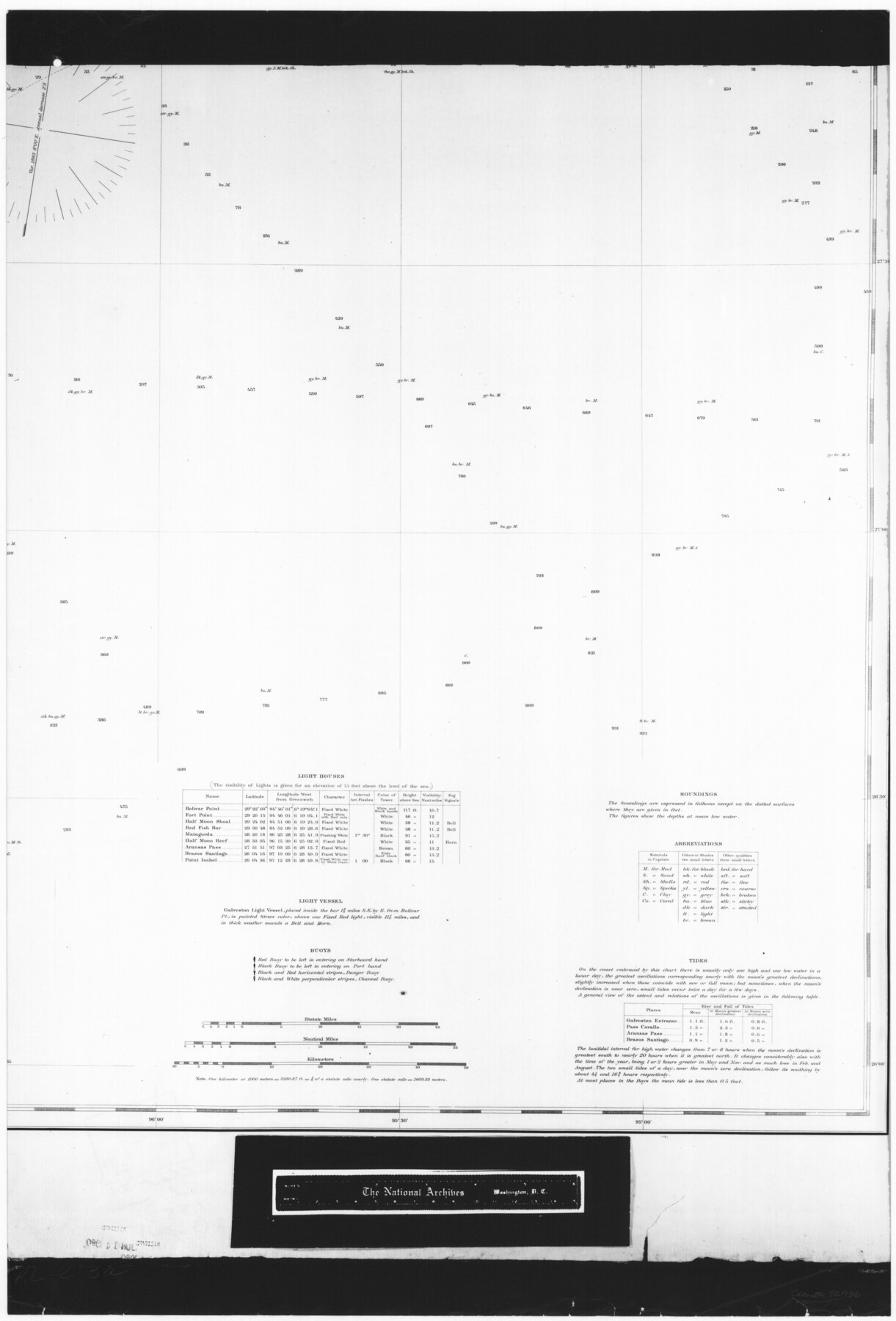
General Chart of the Coast No. XVI - Gulf Coast from Galveston to the Rio Grande
RL-2-3a
-
Map/Doc
72736
-
Collection
General Map Collection
-
Object Dates
1883 (Creation Date)
-
People and Organizations
U. S. Coast and Geodetic Survey (Publisher)
-
Subjects
Nautical Charts
-
Height x Width
26.8 x 18.2 inches
68.1 x 46.2 cm
-
Comments
B/W photostat copy from National Archives in multiple pieces.
Part of: General Map Collection
Bastrop County Sketch File 8

Print $4.00
- Digital $50.00
Bastrop County Sketch File 8
Size 8.5 x 11.5 inches
Map/Doc 14054
Hamilton County Working Sketch 36

Print $40.00
- Digital $50.00
Hamilton County Working Sketch 36
2008
Size 36.9 x 57.3 inches
Map/Doc 88996
Flight Mission No. CUG-1P, Frame 24, Kleberg County

Print $20.00
- Digital $50.00
Flight Mission No. CUG-1P, Frame 24, Kleberg County
1956
Size 18.5 x 22.1 inches
Map/Doc 86114
Val Verde County Rolled Sketch 73

Print $20.00
- Digital $50.00
Val Verde County Rolled Sketch 73
1960
Size 15.0 x 19.4 inches
Map/Doc 8136
Lampasas County Sketch File 3

Print $4.00
- Digital $50.00
Lampasas County Sketch File 3
1856
Size 12.1 x 7.6 inches
Map/Doc 29392
Pecos County Working Sketch 109

Print $40.00
- Digital $50.00
Pecos County Working Sketch 109
1972
Size 34.8 x 56.9 inches
Map/Doc 71582
Texas Gulf Coast Map from the Sabine River to the Rio Grande as subdivided for mineral development

Print $40.00
- Digital $50.00
Texas Gulf Coast Map from the Sabine River to the Rio Grande as subdivided for mineral development
1948
Size 48.9 x 38.0 inches
Map/Doc 2910
Stephens County Working Sketch 2

Print $20.00
- Digital $50.00
Stephens County Working Sketch 2
1918
Size 17.1 x 21.1 inches
Map/Doc 63945
Sutton County Sketch File A

Print $5.00
- Digital $50.00
Sutton County Sketch File A
Size 9.1 x 11.9 inches
Map/Doc 37389
Trinity County Working Sketch 15

Print $20.00
- Digital $50.00
Trinity County Working Sketch 15
1974
Size 30.5 x 32.5 inches
Map/Doc 69464
Zapata County Working Sketch 7

Print $40.00
- Digital $50.00
Zapata County Working Sketch 7
1946
Size 42.8 x 53.4 inches
Map/Doc 62058
Waller County Working Sketch 6

Print $20.00
- Digital $50.00
Waller County Working Sketch 6
1988
Size 31.1 x 20.0 inches
Map/Doc 72305
You may also like
Webb County Sketch File 61

Print $6.00
- Digital $50.00
Webb County Sketch File 61
1944
Size 14.5 x 8.8 inches
Map/Doc 39859
Liberty County Working Sketch 32

Print $20.00
- Digital $50.00
Liberty County Working Sketch 32
1945
Size 29.1 x 46.3 inches
Map/Doc 70491
Flight Mission No. BRE-1P, Frame 28, Nueces County

Print $20.00
- Digital $50.00
Flight Mission No. BRE-1P, Frame 28, Nueces County
1956
Size 16.6 x 16.1 inches
Map/Doc 86624
Guadalupe County Sketch File 15f

Print $10.00
- Digital $50.00
Guadalupe County Sketch File 15f
Size 12.7 x 8.2 inches
Map/Doc 24710
Wilbarger County Working Sketch 10

Print $20.00
- Digital $50.00
Wilbarger County Working Sketch 10
1951
Size 23.5 x 32.3 inches
Map/Doc 72548
Flight Mission No. DIX-5P, Frame 105, Aransas County

Print $20.00
- Digital $50.00
Flight Mission No. DIX-5P, Frame 105, Aransas County
1956
Size 17.7 x 17.8 inches
Map/Doc 83783

General Highway Map. Detail of Cities and Towns in Tyler County, Texas [Woodville and vicinity]
![79691, General Highway Map. Detail of Cities and Towns in Tyler County, Texas [Woodville and vicinity], Texas State Library and Archives](https://historictexasmaps.com/wmedia_w700/maps/79691.tif.jpg)
Print $20.00
General Highway Map. Detail of Cities and Towns in Tyler County, Texas [Woodville and vicinity]
1961
Size 18.1 x 24.8 inches
Map/Doc 79691
Palo Pinto County Working Sketch 2

Print $20.00
- Digital $50.00
Palo Pinto County Working Sketch 2
1906
Size 15.2 x 46.2 inches
Map/Doc 71385
South Sulphur River, Harpers Crossing Sheet

Print $20.00
- Digital $50.00
South Sulphur River, Harpers Crossing Sheet
1925
Size 23.3 x 18.0 inches
Map/Doc 78328
Map of Trinity County

Print $20.00
- Digital $50.00
Map of Trinity County
Size 17.8 x 24.8 inches
Map/Doc 760
Brewster County Working Sketch 81

Print $20.00
- Digital $50.00
Brewster County Working Sketch 81
1972
Size 45.9 x 26.7 inches
Map/Doc 67681