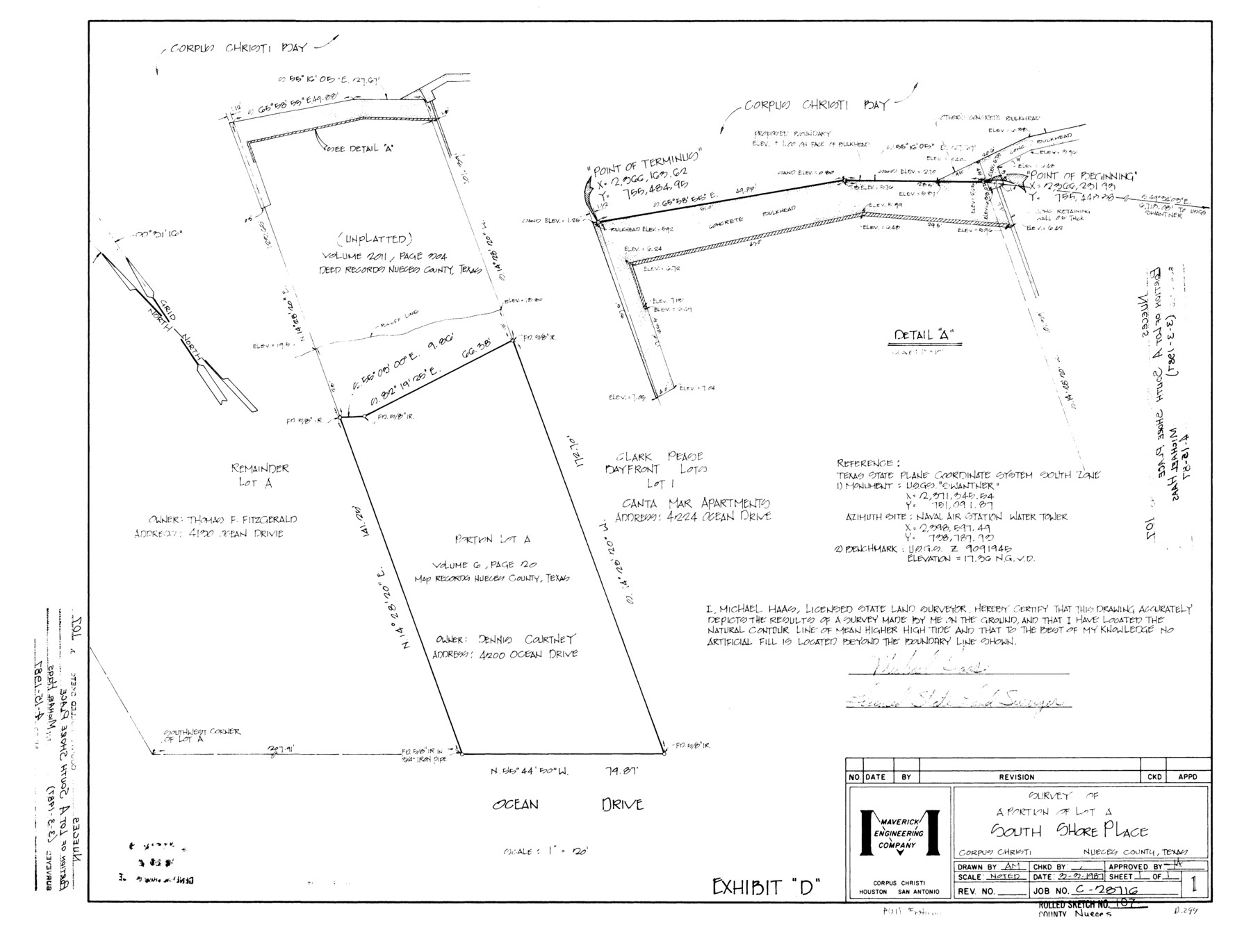
Nueces County Rolled Sketch 107
[Exhibits, survey report, and plats for a survey concerning the shoreline determination for a portion of Lot A, South Shore Place, Corpus Christi]
-
Map/Doc
7104
-
Collection
General Map Collection
-
Object Dates
1987 (Creation Date)
1987 (File Date)
-
People and Organizations
Michael Haas (Surveyor/Engineer)
-
Counties
Nueces
-
Subjects
Surveying Rolled Sketch
-
Height x Width
18.4 x 24.8 inches
46.7 x 63.0 cm
Part of: General Map Collection
Eastland County Working Sketch 40

Print $20.00
- Digital $50.00
Eastland County Working Sketch 40
1970
Size 27.9 x 26.0 inches
Map/Doc 68821
Presidio County Working Sketch 111

Print $20.00
- Digital $50.00
Presidio County Working Sketch 111
1981
Size 17.1 x 20.4 inches
Map/Doc 71788
Culberson County Working Sketch 61

Print $40.00
- Digital $50.00
Culberson County Working Sketch 61
1974
Size 74.9 x 34.0 inches
Map/Doc 68515
St. Louis, Brownsville & Mexico Railway Location Map from Mile 80 to Mile 100

Print $40.00
- Digital $50.00
St. Louis, Brownsville & Mexico Railway Location Map from Mile 80 to Mile 100
1905
Size 19.5 x 64.6 inches
Map/Doc 64166
Controlled Mosaic by Jack Amman Photogrammetric Engineers, Inc - Sheet 4

Print $20.00
- Digital $50.00
Controlled Mosaic by Jack Amman Photogrammetric Engineers, Inc - Sheet 4
1954
Size 20.0 x 24.0 inches
Map/Doc 83448
Flight Mission No. CGI-3N, Frame 110, Cameron County

Print $20.00
- Digital $50.00
Flight Mission No. CGI-3N, Frame 110, Cameron County
1954
Size 18.5 x 22.1 inches
Map/Doc 84590
Robertson County Rolled Sketch 2

Print $43.00
- Digital $50.00
Robertson County Rolled Sketch 2
1974
Size 9.6 x 15.1 inches
Map/Doc 48861

Reagan County Rolled Sketch 8

Print $20.00
- Digital $50.00
Reagan County Rolled Sketch 8
Size 30.2 x 26.7 inches
Map/Doc 7436
Parker County Working Sketch 27

Print $20.00
- Digital $50.00
Parker County Working Sketch 27
2009
Map/Doc 89001
Anderson County

Print $20.00
- Digital $50.00
Anderson County
1871
Size 20.2 x 21.9 inches
Map/Doc 3227
Cherokee County Sketch File 37

Print $40.00
- Digital $50.00
Cherokee County Sketch File 37
1978
Size 11.2 x 8.7 inches
Map/Doc 18225
You may also like
Orange County NRC Article 33.136 Sketch 5

Print $62.00
- Digital $50.00
Orange County NRC Article 33.136 Sketch 5
2014
Size 26.1 x 22.7 inches
Map/Doc 94946
Edwards County Working Sketch 11

Print $20.00
- Digital $50.00
Edwards County Working Sketch 11
1922
Size 18.8 x 31.7 inches
Map/Doc 68887
[Map of the Fort Worth & Denver City Railway]
![64433, [Map of the Fort Worth & Denver City Railway], General Map Collection](https://historictexasmaps.com/wmedia_w700/maps/64433.tif.jpg)
Print $40.00
- Digital $50.00
[Map of the Fort Worth & Denver City Railway]
1887
Size 22.2 x 110.1 inches
Map/Doc 64433
Trinity River, Boyd Crossing Sheet/Chambers Creek

Print $20.00
- Digital $50.00
Trinity River, Boyd Crossing Sheet/Chambers Creek
1931
Size 17.5 x 43.1 inches
Map/Doc 65238
Anderson County Sketch File 11a

Print $6.00
- Digital $50.00
Anderson County Sketch File 11a
1854
Size 8.2 x 8.2 inches
Map/Doc 12768
Callahan County Rolled Sketch 25

Print $20.00
- Digital $50.00
Callahan County Rolled Sketch 25
1974
Size 18.4 x 22.5 inches
Map/Doc 5383

Matagorda County Rolled Sketch 19

Print $20.00
- Digital $50.00
Matagorda County Rolled Sketch 19
1918
Size 13.0 x 16.6 inches
Map/Doc 6687
Val Verde County Sketch File XXX8

Print $6.00
- Digital $50.00
Val Verde County Sketch File XXX8
Size 9.0 x 16.4 inches
Map/Doc 39106
Winkler County

Print $20.00
- Digital $50.00
Winkler County
1932
Size 39.7 x 38.5 inches
Map/Doc 95678
La Salle County Sketch File 19 1/2

Print $28.00
- Digital $50.00
La Salle County Sketch File 19 1/2
1886
Size 14.3 x 8.7 inches
Map/Doc 29515
Gillespie County Working Sketch 9

Print $20.00
- Digital $50.00
Gillespie County Working Sketch 9
1994
Size 27.7 x 32.3 inches
Map/Doc 63172