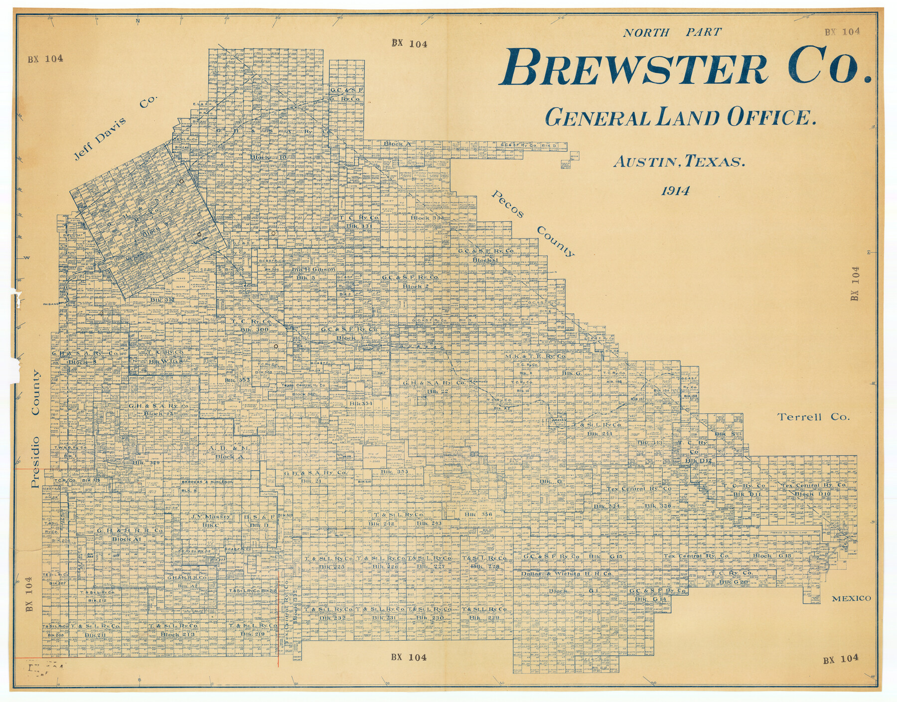
North Part Brewster Co.
BX104
-
Map/Doc
89864
-
Collection
Twichell Survey Records
-
Object Dates
1914 (Creation Date)
-
People and Organizations
General Land Office (Publisher)
-
Counties
Brewster
-
Subjects
County
-
Height x Width
48.4 x 37.8 inches
122.9 x 96.0 cm
Part of: Twichell Survey Records
[Sketch showing I. & G. N. Block 1 along river, Runnels County School Land and Ira G. Yates]
![91595, [Sketch showing I. & G. N. Block 1 along river, Runnels County School Land and Ira G. Yates], Twichell Survey Records](https://historictexasmaps.com/wmedia_w700/maps/91595-1.tif.jpg)
Print $20.00
- Digital $50.00
[Sketch showing I. & G. N. Block 1 along river, Runnels County School Land and Ira G. Yates]
Size 17.2 x 23.3 inches
Map/Doc 91595
Battlefields of the Civil War

Battlefields of the Civil War
1961
Size 25.8 x 19.7 inches
Map/Doc 92373
Platte (sic) of the unorganized County School Lands in the District of Young

Print $20.00
- Digital $50.00
Platte (sic) of the unorganized County School Lands in the District of Young
Size 16.0 x 12.3 inches
Map/Doc 90447
[Sketch of Unknown Area in New Mexico]
![93027, [Sketch of Unknown Area in New Mexico], Twichell Survey Records](https://historictexasmaps.com/wmedia_w700/maps/93027-1.tif.jpg)
Print $40.00
- Digital $50.00
[Sketch of Unknown Area in New Mexico]
Size 50.6 x 37.1 inches
Map/Doc 93027
[Sketch between Wheeler County and Oklahoma]
![89674, [Sketch between Wheeler County and Oklahoma], Twichell Survey Records](https://historictexasmaps.com/wmedia_w700/maps/89674-1.tif.jpg)
Print $40.00
- Digital $50.00
[Sketch between Wheeler County and Oklahoma]
Size 64.9 x 10.2 inches
Map/Doc 89674
[Part of T. & N. O. RR. Co Block 2 and area around Jasper Hays survey]
![90850, [Part of T. & N. O. RR. Co Block 2 and area around Jasper Hays survey], Twichell Survey Records](https://historictexasmaps.com/wmedia_w700/maps/90850-2.tif.jpg)
Print $20.00
- Digital $50.00
[Part of T. & N. O. RR. Co Block 2 and area around Jasper Hays survey]
1907
Size 13.3 x 28.4 inches
Map/Doc 90850
The Rand-McNally New Commercial Atlas Map of Texas

Print $20.00
- Digital $50.00
The Rand-McNally New Commercial Atlas Map of Texas
1913
Size 40.5 x 28.7 inches
Map/Doc 92141
Amended and Corrected Map of Adrian and Adrian Heights Addition Situated in Oldham County, Texas on Sections 14, 15, 38, 39 and 16 Respectively

Print $20.00
- Digital $50.00
Amended and Corrected Map of Adrian and Adrian Heights Addition Situated in Oldham County, Texas on Sections 14, 15, 38, 39 and 16 Respectively
Size 31.5 x 43.5 inches
Map/Doc 89801
Englewood Cemetery Slaton, Texas

Print $20.00
- Digital $50.00
Englewood Cemetery Slaton, Texas
1947
Size 24.4 x 35.2 inches
Map/Doc 92838
[PSL Blocks B8-B9, B13-B18 and B22]
![91963, [PSL Blocks B8-B9, B13-B18 and B22], Twichell Survey Records](https://historictexasmaps.com/wmedia_w700/maps/91963-1.tif.jpg)
Print $20.00
- Digital $50.00
[PSL Blocks B8-B9, B13-B18 and B22]
Size 19.8 x 27.2 inches
Map/Doc 91963
W. D. Twichell's Preliminary Report Showing R. S. Hunnicutt's Reconnoissance Survey in Parmer County, Texas November 6th to 19th, 1915

Print $20.00
- Digital $50.00
W. D. Twichell's Preliminary Report Showing R. S. Hunnicutt's Reconnoissance Survey in Parmer County, Texas November 6th to 19th, 1915
1915
Size 45.1 x 42.8 inches
Map/Doc 89803
Resurvey of Block K-3

Print $20.00
- Digital $50.00
Resurvey of Block K-3
1913
Size 17.0 x 19.0 inches
Map/Doc 90540
You may also like
M. C. Lindsey's Subdivision of Block 20 College Addition to Lamesa, Texas

Print $20.00
- Digital $50.00
M. C. Lindsey's Subdivision of Block 20 College Addition to Lamesa, Texas
1953
Size 9.6 x 18.2 inches
Map/Doc 92589
Brewster County Working Sketch 6

Print $20.00
- Digital $50.00
Brewster County Working Sketch 6
1909
Size 28.6 x 29.5 inches
Map/Doc 67539
Nueces County Rolled Sketch 127 A-F

Print $22.00
Nueces County Rolled Sketch 127 A-F
1998
Size 11.1 x 26.6 inches
Map/Doc 8976
From Citizens of Austin and Harris Counties Living in What Was to Become Fort Bend County for the Creation of a New County (Unnamed), Undated

Print $20.00
From Citizens of Austin and Harris Counties Living in What Was to Become Fort Bend County for the Creation of a New County (Unnamed), Undated
2020
Size 22.6 x 21.7 inches
Map/Doc 96399
Plat Showing Land Owned by City of Lubbock out of Section 3, Block O

Print $20.00
- Digital $50.00
Plat Showing Land Owned by City of Lubbock out of Section 3, Block O
Size 40.4 x 31.1 inches
Map/Doc 92876
Taylor County Rolled Sketch 26

Print $20.00
- Digital $50.00
Taylor County Rolled Sketch 26
1982
Size 35.0 x 35.0 inches
Map/Doc 9987

Brewster County Rolled Sketch 114

Print $20.00
- Digital $50.00
Brewster County Rolled Sketch 114
1964
Size 11.4 x 18.4 inches
Map/Doc 5277
Ward County Working Sketch 42

Print $20.00
- Digital $50.00
Ward County Working Sketch 42
1970
Size 42.2 x 41.3 inches
Map/Doc 72348
Kinney County Working Sketch 16

Print $20.00
- Digital $50.00
Kinney County Working Sketch 16
1946
Size 46.3 x 37.7 inches
Map/Doc 70198
Dimmit County Sketch File 42

Print $2.00
- Digital $50.00
Dimmit County Sketch File 42
1901
Size 6.2 x 3.9 inches
Map/Doc 21171
McMullen County Working Sketch 16

Print $20.00
- Digital $50.00
McMullen County Working Sketch 16
1940
Size 23.8 x 19.8 inches
Map/Doc 70717