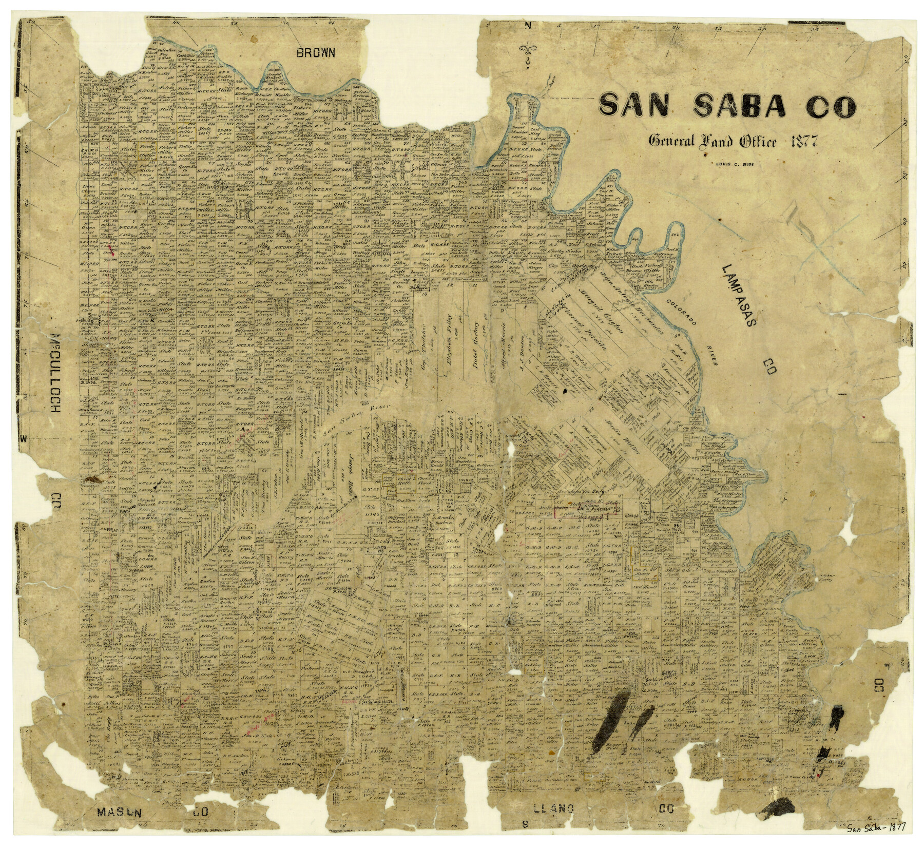
San Saba County
-
Map/Doc
4020
-
Collection
General Map Collection
-
Object Dates
1877 (Creation Date)
-
People and Organizations
Texas General Land Office (Publisher)
Louis C. Wise (Compiler)
Louis C. Wise (Draftsman)
-
Counties
San Saba
-
Subjects
County
-
Height x Width
20.2 x 22.0 inches
51.3 x 55.9 cm
-
Features
China Creek
Spring Creek
Felsen Creek
Council Ground Trail
Sulphur Spring
Simpsons Creek
Camp Creek
San Saba
San Saba River
Colorado River
Salt Creek
Horse Creek
Moore's Creek
Folger Creek
Rocky Creek
Wilbarger's Creek
Terrace Creek
Harry's Creek
Waco Creek
Pecan Bayou
Part of: General Map Collection

Kimble County Working Sketch 8

Print $20.00
- Digital $50.00
Kimble County Working Sketch 8
1918
Size 27.4 x 12.9 inches
Map/Doc 70076
Presidio County Rolled Sketch T-1

Print $20.00
- Digital $50.00
Presidio County Rolled Sketch T-1
Size 26.8 x 27.1 inches
Map/Doc 7416
Jackson County Sketch File 30

Print $52.00
- Digital $50.00
Jackson County Sketch File 30
1944
Size 14.2 x 8.5 inches
Map/Doc 27730
Maps of Gulf Intracoastal Waterway, Texas - Sabine River to the Rio Grande and connecting waterways including ship channels

Print $20.00
- Digital $50.00
Maps of Gulf Intracoastal Waterway, Texas - Sabine River to the Rio Grande and connecting waterways including ship channels
1966
Size 14.2 x 20.7 inches
Map/Doc 61997
El Paso County Rolled Sketch 49

Print $40.00
- Digital $50.00
El Paso County Rolled Sketch 49
Size 10.5 x 99.9 inches
Map/Doc 8875
Houston County Working Sketch 32

Print $20.00
- Digital $50.00
Houston County Working Sketch 32
1987
Size 43.9 x 33.0 inches
Map/Doc 66262
Live Oak County Sketch File 33

Print $4.00
- Digital $50.00
Live Oak County Sketch File 33
1874
Size 11.9 x 7.6 inches
Map/Doc 30333
Calhoun County Sketch File 10

Print $11.00
- Digital $50.00
Calhoun County Sketch File 10
1956
Size 14.3 x 8.8 inches
Map/Doc 35940
Maps of Gulf Intracoastal Waterway, Texas - Sabine River to the Rio Grande and connecting waterways including ship channels

Print $20.00
- Digital $50.00
Maps of Gulf Intracoastal Waterway, Texas - Sabine River to the Rio Grande and connecting waterways including ship channels
1966
Size 14.6 x 22.2 inches
Map/Doc 61952
Pecos County Sketch File 51

Print $16.00
- Digital $50.00
Pecos County Sketch File 51
1881
Size 12.8 x 8.4 inches
Map/Doc 33773
Flight Mission No. DQN-5K, Frame 24, Calhoun County

Print $20.00
- Digital $50.00
Flight Mission No. DQN-5K, Frame 24, Calhoun County
1953
Size 18.5 x 22.1 inches
Map/Doc 84375
You may also like
Briscoe County Sketch File N

Print $40.00
- Digital $50.00
Briscoe County Sketch File N
Size 26.0 x 21.9 inches
Map/Doc 11012
Dimmit County Working Sketch 45

Print $20.00
- Digital $50.00
Dimmit County Working Sketch 45
1979
Size 44.7 x 35.5 inches
Map/Doc 68706
General Highway Map, Crosby County, Texas

Print $20.00
- Digital $50.00
General Highway Map, Crosby County, Texas
1950
Size 25.5 x 18.8 inches
Map/Doc 92597
Marion County Rolled Sketch JRC

Print $20.00
- Digital $50.00
Marion County Rolled Sketch JRC
1953
Size 19.4 x 20.5 inches
Map/Doc 6662
Eastland County Sketch File 8

Print $8.00
- Digital $50.00
Eastland County Sketch File 8
1872
Size 12.9 x 8.1 inches
Map/Doc 21576
Menard County Sketch File 3

Print $40.00
- Digital $50.00
Menard County Sketch File 3
Size 16.3 x 12.9 inches
Map/Doc 31488
Burnet County Working Sketch 18

Print $20.00
- Digital $50.00
Burnet County Working Sketch 18
1980
Size 44.3 x 32.9 inches
Map/Doc 67861
Andrews County Rolled Sketch 40

Print $20.00
- Digital $50.00
Andrews County Rolled Sketch 40
Size 37.2 x 23.0 inches
Map/Doc 77180
Terrell County Working Sketch 37

Print $20.00
- Digital $50.00
Terrell County Working Sketch 37
1950
Size 24.5 x 24.1 inches
Map/Doc 62130
Maps of Gulf Intracoastal Waterway, Texas - Sabine River to the Rio Grande and connecting waterways including ship channels

Print $20.00
- Digital $50.00
Maps of Gulf Intracoastal Waterway, Texas - Sabine River to the Rio Grande and connecting waterways including ship channels
1966
Size 14.5 x 22.2 inches
Map/Doc 61937
Terry County Working Sketch 3

Print $40.00
- Digital $50.00
Terry County Working Sketch 3
1953
Size 125.9 x 28.4 inches
Map/Doc 62108
Garza County Rolled Sketch R1

Print $40.00
- Digital $50.00
Garza County Rolled Sketch R1
Size 32.1 x 49.3 inches
Map/Doc 9045