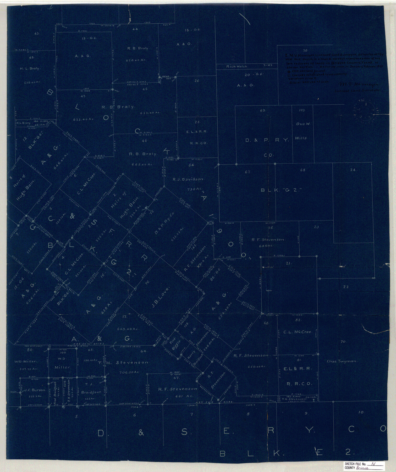
Briscoe County Sketch File N
[Sketch of parts of Blocks A-1900 and G2 in northeast part of county]
-
Map/Doc
11012
-
Collection
General Map Collection
-
Object Dates
1921/3/30 (File Date)
1921 (Survey Date)
-
People and Organizations
M.V. Homeyer (Surveyor/Engineer)
-
Counties
Briscoe
-
Subjects
Surveying Sketch File
-
Height x Width
26.0 x 21.9 inches
66.0 x 55.6 cm
-
Medium
blueprint/diazo
-
Scale
1" = 600 varas
Part of: General Map Collection
Flight Mission No. DIX-10P, Frame 175, Aransas County

Print $20.00
- Digital $50.00
Flight Mission No. DIX-10P, Frame 175, Aransas County
1956
Size 18.6 x 22.2 inches
Map/Doc 83965
Flight Mission No. CRC-3R, Frame 37, Chambers County

Print $20.00
- Digital $50.00
Flight Mission No. CRC-3R, Frame 37, Chambers County
1956
Size 18.6 x 22.4 inches
Map/Doc 84810
Live Oak County Boundary File 9

Print $4.00
- Digital $50.00
Live Oak County Boundary File 9
Size 12.7 x 7.8 inches
Map/Doc 56399
Runnels County

Print $20.00
- Digital $50.00
Runnels County
1948
Size 46.5 x 36.4 inches
Map/Doc 77411
Hunt County Sketch File 20

Print $4.00
- Digital $50.00
Hunt County Sketch File 20
1853
Size 8.3 x 7.9 inches
Map/Doc 27120
Topographical Map of the Rio Grande, Sheet No. 12

Print $20.00
- Digital $50.00
Topographical Map of the Rio Grande, Sheet No. 12
1912
Map/Doc 89536
Aransas County NRC Article 33.136 Sketch 1

Print $55.00
- Digital $50.00
Aransas County NRC Article 33.136 Sketch 1
2000
Size 24.8 x 35.6 inches
Map/Doc 61630
Terrell County Working Sketch 11

Print $20.00
- Digital $50.00
Terrell County Working Sketch 11
1934
Size 18.5 x 15.0 inches
Map/Doc 62160
Lavaca County Working Sketch 20

Print $20.00
- Digital $50.00
Lavaca County Working Sketch 20
1980
Size 19.2 x 26.0 inches
Map/Doc 70373
Flight Mission No. DIX-6P, Frame 180, Aransas County

Print $20.00
- Digital $50.00
Flight Mission No. DIX-6P, Frame 180, Aransas County
1956
Size 19.0 x 22.6 inches
Map/Doc 83842
Flight Mission No. CRK-8P, Frame 120, Refugio County

Print $20.00
- Digital $50.00
Flight Mission No. CRK-8P, Frame 120, Refugio County
1956
Size 18.4 x 22.1 inches
Map/Doc 86975
Kleberg County Rolled Sketch 10-42

Print $20.00
- Digital $50.00
Kleberg County Rolled Sketch 10-42
1952
Size 42.7 x 36.4 inches
Map/Doc 9380
You may also like
Brewster County Sketch File 48

Print $4.00
- Digital $50.00
Brewster County Sketch File 48
1940
Size 11.4 x 9.2 inches
Map/Doc 16327
Hoffman & Walker's Pictorial, Historical Map of Texas

Hoffman & Walker's Pictorial, Historical Map of Texas
1960
Size 43.4 x 45.3 inches
Map/Doc 93275
[Pablo Montoya Grant]
![93160, [Pablo Montoya Grant], Twichell Survey Records](https://historictexasmaps.com/wmedia_w700/maps/93160-1.tif.jpg)
Print $40.00
- Digital $50.00
[Pablo Montoya Grant]
Size 50.1 x 52.3 inches
Map/Doc 93160
Pecos County Rolled Sketch 85

Print $20.00
- Digital $50.00
Pecos County Rolled Sketch 85
1931
Size 36.7 x 24.4 inches
Map/Doc 7243
Jefferson County Working Sketch 14

Print $20.00
- Digital $50.00
Jefferson County Working Sketch 14
1948
Size 30.3 x 25.8 inches
Map/Doc 66557
Garza County Sketch File E

Print $20.00
- Digital $50.00
Garza County Sketch File E
Size 16.0 x 15.7 inches
Map/Doc 11552
Presidio County Working Sketch 84

Print $20.00
- Digital $50.00
Presidio County Working Sketch 84
1970
Size 20.7 x 17.8 inches
Map/Doc 71761
Lamb County Sketch File B

Print $6.00
- Digital $50.00
Lamb County Sketch File B
1902
Size 11.2 x 8.8 inches
Map/Doc 29344
Jefferson County Rolled Sketch 46

Print $3.00
- Digital $50.00
Jefferson County Rolled Sketch 46
Size 15.7 x 10.0 inches
Map/Doc 9304
Plat of Section No. 44, Blk. No. 4, T. & P. RR. Co. showing subdivisions of same with 3.1 acre survey made for W. D. Twichell

Print $2.00
- Digital $50.00
Plat of Section No. 44, Blk. No. 4, T. & P. RR. Co. showing subdivisions of same with 3.1 acre survey made for W. D. Twichell
1919
Size 8.9 x 13.3 inches
Map/Doc 91908
Crane County Rolled Sketch 25

Print $20.00
- Digital $50.00
Crane County Rolled Sketch 25
2019
Size 36.2 x 23.8 inches
Map/Doc 95746
Van Zandt County Sketch File 15a

Print $4.00
- Digital $50.00
Van Zandt County Sketch File 15a
1858
Size 6.7 x 8.1 inches
Map/Doc 39406