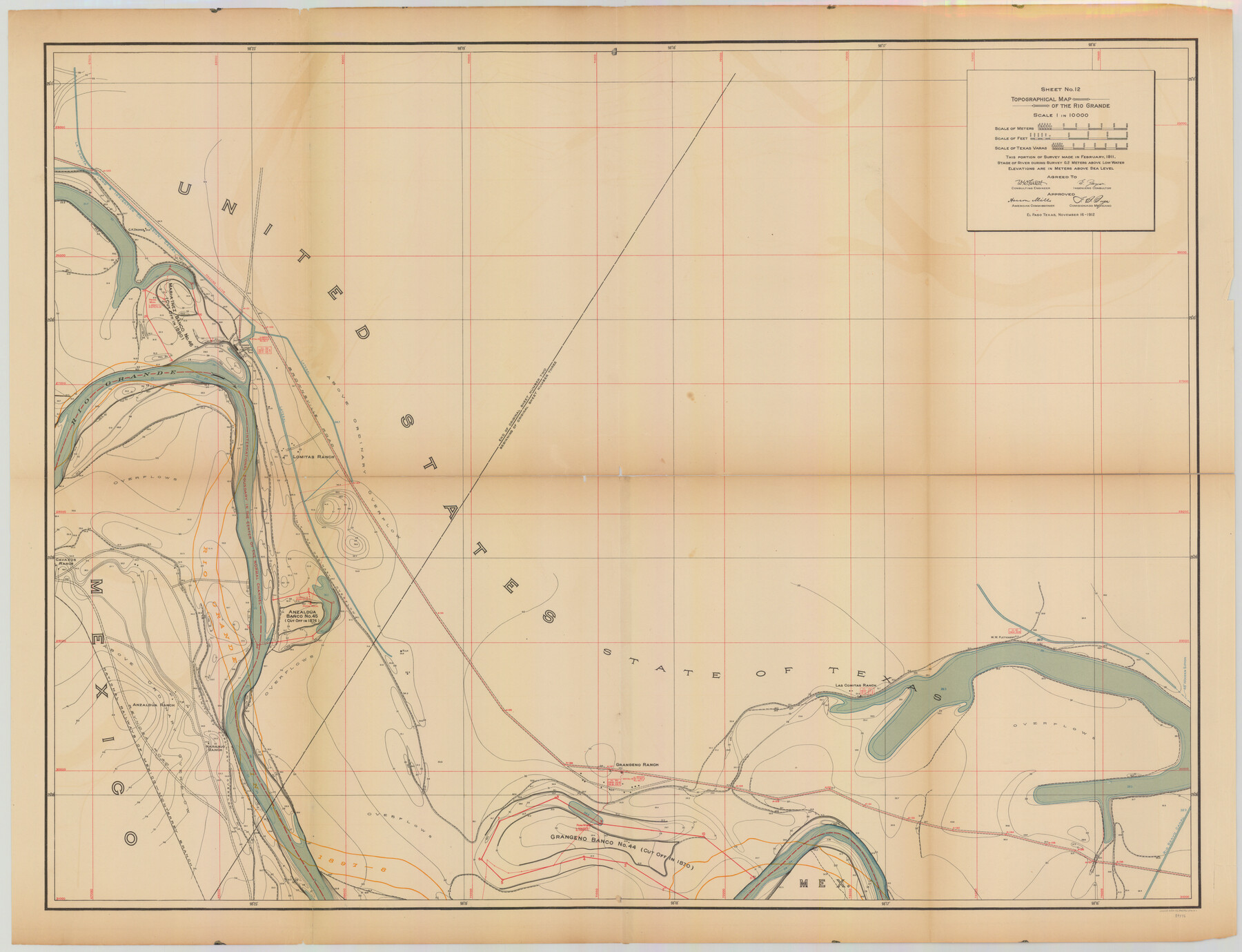
Topographical Map of the Rio Grande, Sheet No. 12
[from book: "Survey of the Rio Grande, Roma to the Gulf of Mexico, Reports and Maps"]
-
Map/Doc
89536
-
Collection
General Map Collection
-
Object Dates
1912/11/16 (Creation Date)
-
People and Organizations
International Boundary Commission (Publisher)
Anson Mills (Author)
E. Zayas (Surveyor/Engineer)
F.B. Puga (Author)
W.W. Follett (Surveyor/Engineer)
-
Subjects
River Surveys Texas Boundaries Topographic
-
Medium
paper
-
Scale
1:10000
-
Comments
This portion of the survey made in February, 1911. State of river during survey 0.2 meters above low water. Elevations are in meters above sea level. This map and 31 others were originally folded and bound into a book titled "Survey of the Rio Grande
Part of: General Map Collection
Johnson County State of Texas

Print $20.00
- Digital $50.00
Johnson County State of Texas
1888
Size 30.2 x 35.3 inches
Map/Doc 3733
Fort Bend County State Real Property Sketch 10

Print $40.00
- Digital $50.00
Fort Bend County State Real Property Sketch 10
1985
Size 43.4 x 34.7 inches
Map/Doc 61684
Hutchinson County Rolled Sketch 27

Print $53.00
- Digital $50.00
Hutchinson County Rolled Sketch 27
1920
Size 33.3 x 27.1 inches
Map/Doc 6289
Hood County Sketch File 16

Print $4.00
- Digital $50.00
Hood County Sketch File 16
1860
Size 10.2 x 8.2 inches
Map/Doc 26597
[Maps of surveys in Reeves & Culberson Cos]
![61134, [Maps of surveys in Reeves & Culberson Cos], General Map Collection](https://historictexasmaps.com/wmedia_w700/maps/61134.tif.jpg)
Print $20.00
- Digital $50.00
[Maps of surveys in Reeves & Culberson Cos]
1937
Size 30.7 x 24.9 inches
Map/Doc 61134
Dawson County Sketch File 14

Print $4.00
- Digital $50.00
Dawson County Sketch File 14
Size 11.5 x 7.5 inches
Map/Doc 20547
Liberty County Rolled Sketch JP2

Print $40.00
- Digital $50.00
Liberty County Rolled Sketch JP2
1935
Size 52.0 x 12.5 inches
Map/Doc 9568
Hardin County Sketch File 57

Print $40.00
- Digital $50.00
Hardin County Sketch File 57
Size 15.4 x 14.1 inches
Map/Doc 25228
Brewster County Working Sketch 22

Print $20.00
- Digital $50.00
Brewster County Working Sketch 22
1939
Size 18.4 x 30.7 inches
Map/Doc 67556
Montgomery County Rolled Sketch 38A

Print $40.00
- Digital $50.00
Montgomery County Rolled Sketch 38A
1962
Size 25.1 x 54.7 inches
Map/Doc 9546
Medina County Sketch File 15

Print $6.00
- Digital $50.00
Medina County Sketch File 15
1943
Size 14.2 x 8.5 inches
Map/Doc 31473
Flight Mission No. BRA-16M, Frame 163, Jefferson County

Print $20.00
- Digital $50.00
Flight Mission No. BRA-16M, Frame 163, Jefferson County
1953
Size 18.6 x 22.3 inches
Map/Doc 85761
You may also like
Map of Sections 1-60 Block 46, H. & T. C. RR. Co. Survey according to courses and distances - Maddox survey

Print $40.00
- Digital $50.00
Map of Sections 1-60 Block 46, H. & T. C. RR. Co. Survey according to courses and distances - Maddox survey
Size 75.6 x 20.2 inches
Map/Doc 93129
McLennan County Sketch File 7a

Print $4.00
- Digital $50.00
McLennan County Sketch File 7a
1850
Size 10.3 x 7.4 inches
Map/Doc 31246
[H. & G. N. RR. Co. Block 1]
![90892, [H. & G. N. RR. Co. Block 1], Twichell Survey Records](https://historictexasmaps.com/wmedia_w700/maps/90892-1.tif.jpg)
Print $20.00
- Digital $50.00
[H. & G. N. RR. Co. Block 1]
1902
Size 14.9 x 15.8 inches
Map/Doc 90892
Stephens County Rolled Sketch 4

Print $20.00
- Digital $50.00
Stephens County Rolled Sketch 4
Size 20.0 x 18.5 inches
Map/Doc 7841
Galveston Bay and Approaches

Print $20.00
- Digital $50.00
Galveston Bay and Approaches
1938
Size 45.4 x 34.6 inches
Map/Doc 69875
Upshur County Sketch File 3a

Print $2.00
- Digital $50.00
Upshur County Sketch File 3a
Size 6.5 x 7.1 inches
Map/Doc 38736
Flight Mission No. DCL-5C, Frame 75, Kenedy County

Print $20.00
- Digital $50.00
Flight Mission No. DCL-5C, Frame 75, Kenedy County
1943
Size 18.6 x 22.2 inches
Map/Doc 85858
[St. Louis & Southwestern]
![64281, [St. Louis & Southwestern], General Map Collection](https://historictexasmaps.com/wmedia_w700/maps/64281.tif.jpg)
Print $20.00
- Digital $50.00
[St. Louis & Southwestern]
Size 20.9 x 29.0 inches
Map/Doc 64281
Flight Mission No. DQN-1K, Frame 135, Calhoun County

Print $20.00
- Digital $50.00
Flight Mission No. DQN-1K, Frame 135, Calhoun County
1953
Size 18.3 x 22.4 inches
Map/Doc 84198
Current Miscellaneous File 78

Print $22.00
- Digital $50.00
Current Miscellaneous File 78
1954
Size 10.7 x 8.4 inches
Map/Doc 74199
Flight Mission No. BQY-4M, Frame 31, Harris County

Print $20.00
- Digital $50.00
Flight Mission No. BQY-4M, Frame 31, Harris County
1953
Size 18.5 x 22.3 inches
Map/Doc 85246
Jones County Rolled Sketch 1

Print $20.00
- Digital $50.00
Jones County Rolled Sketch 1
1957
Size 26.1 x 28.3 inches
Map/Doc 6450