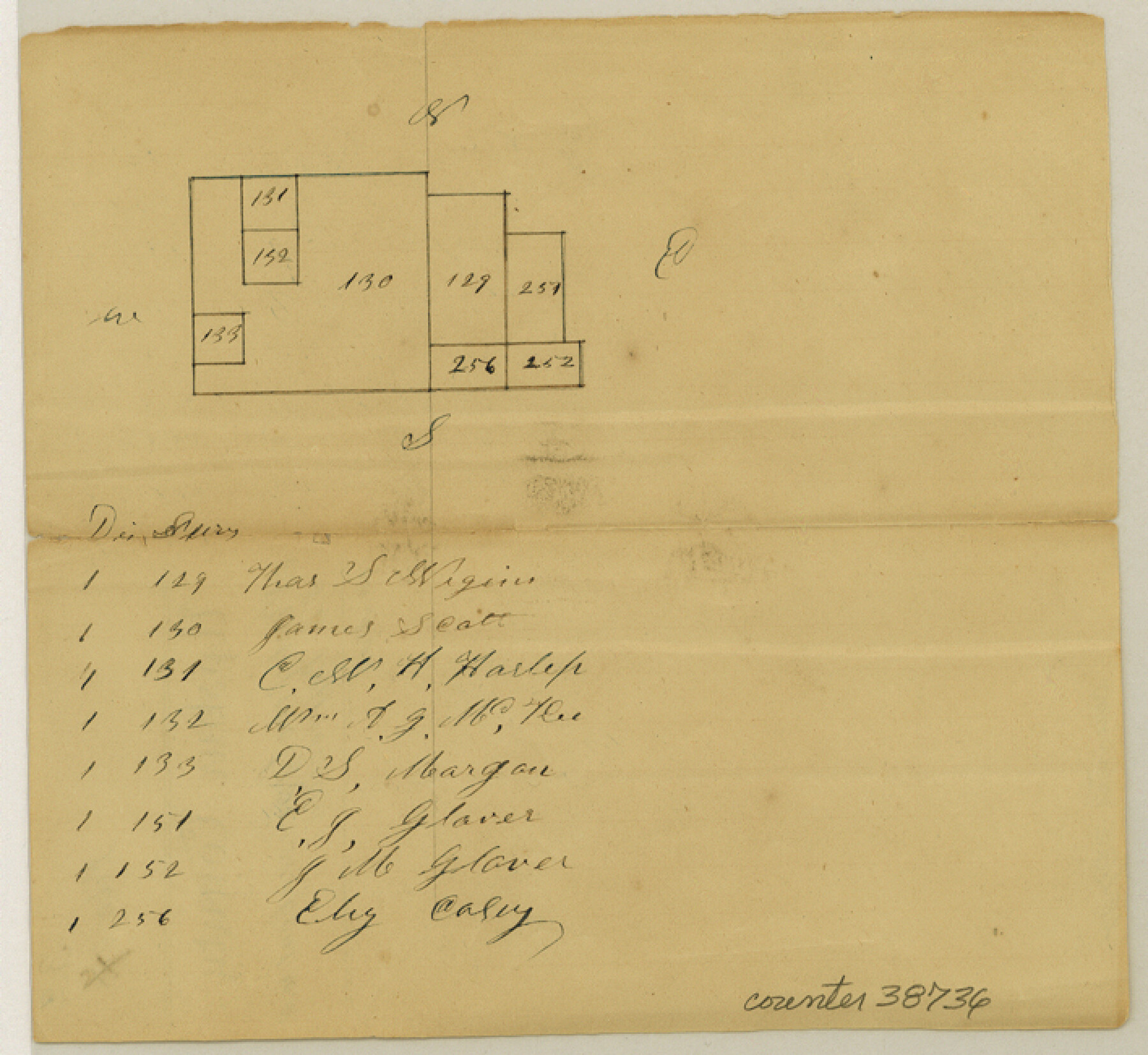
Upshur County Sketch File 3a
[Sketch of surveys in the southeast corner of the county north of Little Cypress Creek]
-
Map/Doc
38736
-
Collection
General Map Collection
-
Counties
Upshur Harrison
-
Subjects
Surveying Sketch File
-
Height x Width
6.5 x 7.1 inches
16.5 x 18.0 cm
-
Medium
paper, manuscript
-
Features
Cypress Creek
Part of: General Map Collection
Limestone County Sketch File 3

Print $4.00
- Digital $50.00
Limestone County Sketch File 3
1850
Size 7.9 x 10.7 inches
Map/Doc 30158
Wichita County Working Sketch 13

Print $20.00
- Digital $50.00
Wichita County Working Sketch 13
1921
Size 16.5 x 32.8 inches
Map/Doc 72523
Henderson County Working Sketch Graphic Index

Print $40.00
- Digital $50.00
Henderson County Working Sketch Graphic Index
1988
Size 37.1 x 64.7 inches
Map/Doc 76576
[Surveys in the Bexar District along the Guadalupe River]
![124, [Surveys in the Bexar District along the Guadalupe River], General Map Collection](https://historictexasmaps.com/wmedia_w700/maps/124.tif.jpg)
Print $3.00
- Digital $50.00
[Surveys in the Bexar District along the Guadalupe River]
1841
Size 17.2 x 10.8 inches
Map/Doc 124

Blanco County Sketch File 17

Print $4.00
- Digital $50.00
Blanco County Sketch File 17
Size 12.2 x 7.9 inches
Map/Doc 14592
Crockett County Working Sketch 40

Print $20.00
- Digital $50.00
Crockett County Working Sketch 40
1928
Size 29.5 x 23.7 inches
Map/Doc 68373
United States - Gulf Coast - From Latitude 26° 33' to the Rio Grande Texas

Print $20.00
- Digital $50.00
United States - Gulf Coast - From Latitude 26° 33' to the Rio Grande Texas
1918
Size 27.6 x 18.2 inches
Map/Doc 72851
McLennan County Sketch File 5

Print $9.00
- Digital $50.00
McLennan County Sketch File 5
Size 11.0 x 17.0 inches
Map/Doc 31240
Nouvelle Carte du Mexique du Texas et d'une partie des états limitrophes

Print $20.00
- Digital $50.00
Nouvelle Carte du Mexique du Texas et d'une partie des états limitrophes
1834
Size 39.9 x 27.4 inches
Map/Doc 94098
Flight Mission No. CRC-4R, Frame 162, Chambers County

Print $20.00
- Digital $50.00
Flight Mission No. CRC-4R, Frame 162, Chambers County
1956
Size 18.6 x 22.4 inches
Map/Doc 84921
[Surveys possibly in Austin County]
![78356, [Surveys possibly in Austin County], General Map Collection](https://historictexasmaps.com/wmedia_w700/maps/78356.tif.jpg)
Print $3.00
- Digital $50.00
[Surveys possibly in Austin County]
Size 17.0 x 9.6 inches
Map/Doc 78356
You may also like
Parker County Sketch File 15A

Print $20.00
- Digital $50.00
Parker County Sketch File 15A
1875
Size 28.5 x 13.6 inches
Map/Doc 12144
Lubbock County Working Sketch 8

Print $20.00
- Digital $50.00
Lubbock County Working Sketch 8
1989
Size 27.4 x 25.2 inches
Map/Doc 70668
Webb County Sketch File 54

Print $46.00
- Digital $50.00
Webb County Sketch File 54
1939
Size 11.3 x 8.8 inches
Map/Doc 39841
Menard County Sketch File 22

Print $8.00
- Digital $50.00
Menard County Sketch File 22
1927
Size 7.4 x 8.6 inches
Map/Doc 31553
Borden County Rolled Sketch 4

Print $40.00
- Digital $50.00
Borden County Rolled Sketch 4
Size 57.4 x 55.0 inches
Map/Doc 8447
Topographical Map of the Rio Grande, Sheet No. 19

Print $20.00
- Digital $50.00
Topographical Map of the Rio Grande, Sheet No. 19
1912
Map/Doc 89543
Jefferson County Working Sketch 4

Print $20.00
- Digital $50.00
Jefferson County Working Sketch 4
1930
Size 19.4 x 28.0 inches
Map/Doc 66547
San Patricio County Rolled Sketch 27

Print $40.00
- Digital $50.00
San Patricio County Rolled Sketch 27
Size 49.5 x 37.8 inches
Map/Doc 9890
Wharton County

Print $20.00
- Digital $50.00
Wharton County
1946
Size 41.4 x 46.9 inches
Map/Doc 77455
[Sketch showing School Lands]
![90449, [Sketch showing School Lands], Twichell Survey Records](https://historictexasmaps.com/wmedia_w700/maps/90449-1.tif.jpg)
Print $20.00
- Digital $50.00
[Sketch showing School Lands]
Size 25.4 x 12.5 inches
Map/Doc 90449
Ward County Working Sketch 23

Print $40.00
- Digital $50.00
Ward County Working Sketch 23
1953
Size 29.1 x 59.5 inches
Map/Doc 72329
University Land Field Notes for Block 13 in Crockett County, Block 11 in Reagan County, Block 12 in Crockett and Reagan Counties, Block 14 in Crockett and Upton Counties, and Block 15 in Upton County

University Land Field Notes for Block 13 in Crockett County, Block 11 in Reagan County, Block 12 in Crockett and Reagan Counties, Block 14 in Crockett and Upton Counties, and Block 15 in Upton County
Map/Doc 81717