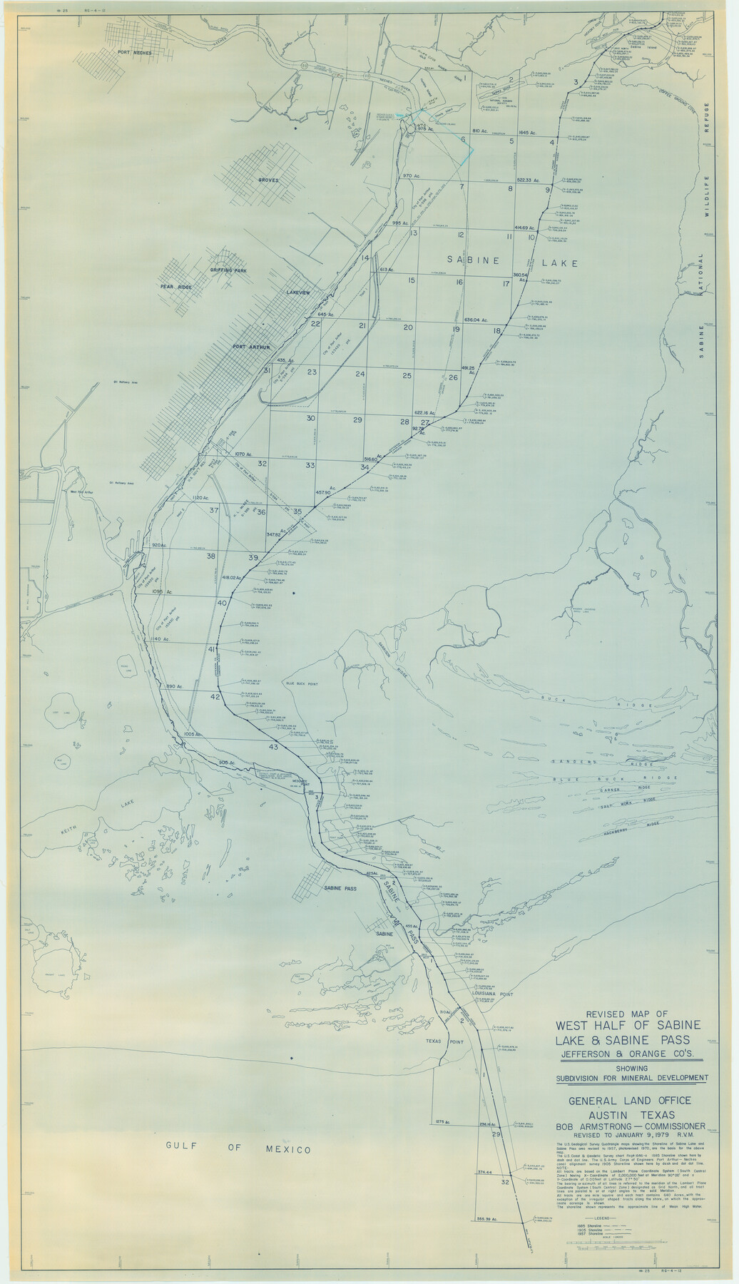
Revised map of west half of Sabine Lake and Sabine Pass, showing subdivision for mineral development; Jefferson and Orange Counties
-
Map/Doc
1935
-
Collection
General Map Collection
-
Object Dates
1/9/1979 (Creation Date)
-
People and Organizations
General Land Office (Publisher)
-
Counties
Jefferson Orange
-
Subjects
Energy Offshore Submerged Area
-
Height x Width
72.1 x 41.5 inches
183.1 x 105.4 cm
-
Medium
tracing
-
Scale
1" = 2000 feet
-
Comments
Gulf coast and submerged state lands. Revised January 9, 1979.
"#25" and "RG-4-12" in lower right and upper left margins.
Part of: General Map Collection
Guadalupe County Sketch File 23

Print $22.00
- Digital $50.00
Guadalupe County Sketch File 23
1859
Size 25.5 x 19.0 inches
Map/Doc 11592
Flight Mission No. BRA-8M, Frame 65, Jefferson County

Print $20.00
- Digital $50.00
Flight Mission No. BRA-8M, Frame 65, Jefferson County
1953
Size 18.6 x 22.4 inches
Map/Doc 85585
Galveston / Texas City, Texas Street Map

Galveston / Texas City, Texas Street Map
2000
Size 36.1 x 24.2 inches
Map/Doc 96855
Liberty County Working Sketch 23

Print $20.00
- Digital $50.00
Liberty County Working Sketch 23
1941
Size 29.9 x 26.4 inches
Map/Doc 70482
Sutton County Rolled Sketch 57

Print $40.00
- Digital $50.00
Sutton County Rolled Sketch 57
1958
Size 40.1 x 51.1 inches
Map/Doc 10662
Flight Mission No. DAH-9M, Frame 158, Orange County

Print $20.00
- Digital $50.00
Flight Mission No. DAH-9M, Frame 158, Orange County
1953
Size 18.4 x 22.3 inches
Map/Doc 86857
San Jacinto County Working Sketch 27

Print $20.00
- Digital $50.00
San Jacinto County Working Sketch 27
1944
Size 30.5 x 23.3 inches
Map/Doc 63740

Pecos County Rolled Sketch 59

Print $20.00
- Digital $50.00
Pecos County Rolled Sketch 59
1922
Size 16.6 x 17.0 inches
Map/Doc 7231
Terrell County Working Sketch 37

Print $20.00
- Digital $50.00
Terrell County Working Sketch 37
1950
Size 24.5 x 24.1 inches
Map/Doc 62130
Hudspeth County Working Sketch 54

Print $20.00
- Digital $50.00
Hudspeth County Working Sketch 54
1989
Size 18.8 x 36.2 inches
Map/Doc 66339
Frio County Sketch File 2a

Print $6.00
- Digital $50.00
Frio County Sketch File 2a
1861
Size 16.0 x 11.0 inches
Map/Doc 23107
You may also like
Flight Mission No. BRA-8M, Frame 142, Jefferson County

Print $20.00
- Digital $50.00
Flight Mission No. BRA-8M, Frame 142, Jefferson County
1953
Size 18.5 x 22.1 inches
Map/Doc 85634
Kent County Boundary File 4b

Print $36.00
- Digital $50.00
Kent County Boundary File 4b
Size 14.2 x 8.7 inches
Map/Doc 55847

Sheet 1 copied from Champlin Book 5 [Strip Map showing T. & P. connecting lines]
![93177, Sheet 1 copied from Champlin Book 5 [Strip Map showing T. & P. connecting lines], Twichell Survey Records](https://historictexasmaps.com/wmedia_w700/maps/93177-1.tif.jpg)
Print $40.00
- Digital $50.00
Sheet 1 copied from Champlin Book 5 [Strip Map showing T. & P. connecting lines]
1909
Size 7.8 x 72.4 inches
Map/Doc 93177
Map of the County of Cameron

Print $40.00
- Digital $50.00
Map of the County of Cameron
1884
Size 57.0 x 33.2 inches
Map/Doc 78646
Harris County Sketch File 80a

Print $20.00
- Digital $50.00
Harris County Sketch File 80a
1892
Size 27.8 x 17.6 inches
Map/Doc 11667
Liberty County Sketch File 28

Print $6.00
- Digital $50.00
Liberty County Sketch File 28
Size 5.2 x 8.0 inches
Map/Doc 29952
Gregg County Sketch File 1E

Print $4.00
- Digital $50.00
Gregg County Sketch File 1E
1849
Size 12.6 x 8.2 inches
Map/Doc 24545
Orange County Sketch File 27

Print $20.00
- Digital $50.00
Orange County Sketch File 27
1915
Size 18.6 x 21.8 inches
Map/Doc 12123
Saline Ranch in Mason, Kimble and Menard Counties

Print $20.00
- Digital $50.00
Saline Ranch in Mason, Kimble and Menard Counties
1916
Size 28.6 x 27.4 inches
Map/Doc 75808
Galveston County Sketch File 8

Print $4.00
- Digital $50.00
Galveston County Sketch File 8
1862
Size 11.2 x 8.8 inches
Map/Doc 23365
Hunt County Working Sketch 1

Print $20.00
- Digital $50.00
Hunt County Working Sketch 1
Size 18.2 x 17.2 inches
Map/Doc 66348